Saline solution: Pacific Northwest tribes have assumed stewardship of the Center for Coastal Margin Observation and Prediction, which tracks water quality in and around the Columbia River Estuary. Photo by Charles Simenstad, University of Washington
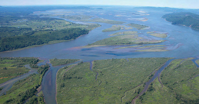
By Chuck Thompson. June 25, 2020. The freshwater plume that discharges from the Columbia River into the Pacific Ocean around Astoria, Oregon, is an ever-changing phenomenon. Near the Columbia River Estuary at the mouth of the river it may be mostly freshwater; as it expands into the Pacific it becomes brackish; in places it might be a 50-50 mix of fresh- and saltwater; eventually ocean water overtakes it completely.
During heavy flow periods in spring the plume can extend 100 miles offshore at its outermost edge and as far south as Newport, Oregon. In fall, it’s a more localized feature around the mouth of the river, and can spread like a narrow jet along the Washington coast less than 10 miles from shore.
Winds and the Coriolis effect also impact its position.
Linked to salmon survival, water conditions in the estuary are vital to the health of the entire Columbia River Basin. But it’s a tricky thing to study.
As of this month, the primary research operation monitoring the flow and chemistry of waters in the Columbia River Estuary and offshore areas has a new overseer.
On June 1, the Oregon Health & Science University (OHSU) officially transferred operational control of the Center for Coastal Margin Observation and Prediction (CMOP) to the Columbia River Inter-Tribal Fish Commission (CRITFC).
The eye-glazing alphabet soup of acronyms notwithstanding, it’s a massive and significant deal.
For CRITFC, acquisition of the nationally renowned CMOP builds on a growing capacity for world-class research. The center collects and analyzes estuary data that informs everything from Columbia River Treaty negotiations to industrial dredging operations to salmon recovery strategies.
MORE ON CI: Revitalizing wetlands in the Columbia River Estuary
“This is a tremendous capacity-building advance for the Columbia River tribes,” says CRITFC chairman Jeremy Red Star Wolf. “Our professional river and salmon management staffs have wanted more ocean and river connectivity in research, applied science and management. CMOP will help deliver that.”
CRITFC coordinates management policy and provides fisheries technical services for the Yakama, Warm Springs, Umatilla and Nez Perce tribes.
“So often the general population’s perception of tribes are either that they’re caught in the past or are just about fishing,” says CRITFC spokesman Jeremy FiveCrows. “People have no idea we’re doing this much primary science. In co-managing this resource, we’re managing at the same level as state and federal agencies.
“Our Hagerman Genetics Laboratory (in Idaho) is one of the foremost fish genetics labs in the whole country. Adding CMOP, a primary science source, under the umbrella of a tribe, can really change peoples’ ideas of who tribes are today.”
What is ‘coastal-margin science’?
CMOP acquires data through a network of observation stations and buoys, many equipped with radio telemetry. (Some stations are currently inactive due to coronavirus-related restrictions.) Underwater “gliders” that roam the coast also collect data.
The network ranges from points offshore as far up the Columbia River as Camas-Washougal, Washington.
Research staff use computer models to verify and expand the scope of observations. All data are publicly accessible and used by federal, state and tribal agencies. The information is also used by fishers, shipping companies, aquaculture businesses, weather forecasters, public utilities, search-and-rescue teams and others to make informed operational decisions.
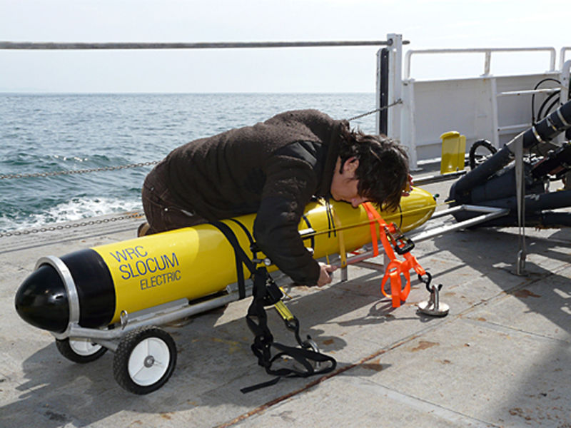
Deep dive: Remote-controlled underwater drones (“gliders”) collect water samples at varying depths and use sensors to measure chemical and biological conditions of ocean water. Photo coutesy CMOP
CMOP calls its primary pursuit “coastal-margin science.” Numerous organizations and academics conduct research in transitional aquatic environments. But the study of these critical near- and offshore zones isn’t traditionally recognized as a single discipline in the way of oceanography or limnology, the study of bodies of freshwater, such as rivers and lakes.
According to its own website, “CMOP is creating a new paradigm for conducting coastal-margin science. It is anticipatory rather than reactive, and is based on an information-rich environment where sensors, models and people all generate and freely share information. We call these integrations ‘collaboratories.’”
“One of the important things we do is long-term observation,” says CMOP coordinator Charles Seaton, who is making the transition from OHSU to CRITFC. “A lot of scientific research tends to be more focused on a specific question you want to answer. You put out instruments and do observations for a week or a month or a year and get data to answer a particular question you are interested in.
“For understanding the long-term health of the system and being able to see what changes there are, for instance as climate change progresses, you have to observe constantly for a very long period of time. You can’t say the estuary has become saltier if you don’t know what the variability of the estuary is like over the long period. You really have to be watching for decades to see that that’s happening and be able to predict how it will go in the future.”
Bridging a ‘balkanized’ river
CRITFC has worked closely with CMOP for more than a decade. By 2018, when the idea for CMOP integration with CRITFC was first raised, the organizations had a tight connection.
“We are proud of the work that the CMOP team has accomplished and are confident that CRITFC will continue to sustain and expand this mission in the future,” said Daniel L. Marks, senior associate dean for research in the OHSU School of Medicine in a press release. “We believe that the momentum and trust built during this collaborative transfer process will serve as a model for ongoing collaboration with CRITFC and tribal communities.”
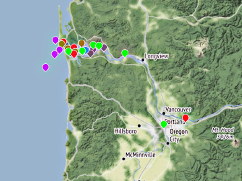
Station master: CMOP’s observation network includes devices attached to offshore buoys and fixed positions. Icon colors indicate station status: purple for seasonal; green for real-time; red for offline; blue for self-recording; brown for low-priority; gray for historical. Image from CMOP website
According to Chuck Hudson, CRITFC director of government affairs, one of CMOP’s primary remits is to serve as a bridge between river and ocean knowledge and agencies.
“In the Columbia Basin you have a very balkanized, massive watershed that spans two countries and seven states,” says Hudson. “All sorts of different jurisdictions and agencies are often charged with conflicting mandates—say, irrigated agriculture, river navigation or forest work.
“CRITFC has done some of its best work in breaking down the balkanization … but we still find Columbia Basin politicians and mangers and responsible parties throwing their hands up and saying, ‘It really doesn’t matter what we do in the rivers, it’s all ocean conditions.’ Or ‘The ocean is just this big black box, we don’t know what’s going on. What does it matter what we do here in the Columbia River?’
“The ocean has become an easy scapegoat to diminish responsibility for things we try to do in the river. Our program managers have been asking for capacity to better link Columbia River science and management and knowledge with ocean knowledge and management systems. … CMOP appears to us to be that perfect link to bridge those two knowledge and management areas.”
Following the fish
CMOP funding is primarily allocated through the U.S. Department of Commerce. Funding flows through various partner entities, including the National Oceanic and Atmospheric Administration, the U.S. Integrated Ocean Observation System and Northwest Association of Networked Coastal and Ocean Observing Systems.
The Portland-based Meyer Memorial Trust provided a $350,000 tribal science capacity-building grant to CRITFC to help facilitate the transfer of CMOP from OHSU.
Although CMOP headquarters will be moved from OHSU in Southwest Portland to CRITFC offices in Northeast Portland, physical operations will continue to be based in Astoria.
MORE ON CI: Landowners take FERC to court in hopes of blocking LNG pipeline
“The health and wellbeing of Oregonians starts with a healthy environment,” said Dr. Antonio Baptista, longtime CMOP director and a retiring professor at OHSU, in a press release. “CMOP developed, for the Columbia River Estuary, the tools and culture needed to build scientific consensus on sustainable development under a changing climate. As natural stewards of the Columbia River, the tribes are in an outstanding position to expand and bring a centuries-long perspective to what we started decades ago.”
“Our co-management ethos dictates that wherever the salmon go, we go with them,” said CRITFC executive director Jaime A. Pinkham. “We intend to maintain the current capacity of the program and use it as a new beginning alongside public and nonprofit partners to bring tribal co-management and vision in the estuary and ocean environments.”