Stay Updated Subscribe today for the latest research + reporting about environmental news. Subscribe Now

Stay Updated Subscribe today for the latest research + reporting about environmental news.

Subscribe Now

Chuck Thompson

Chuck Thompson

Chuck Thompson

About Chuck Thompson

Chuck Thompson is editor of Columbia Insight.

Ugh! Trash in Gorge at ‘crisis level’

Dumpsters and garbage cans are overwhelmed by illegal dumping. That’s just the start of record levels of abuse of public lands

Trail trash

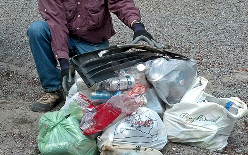
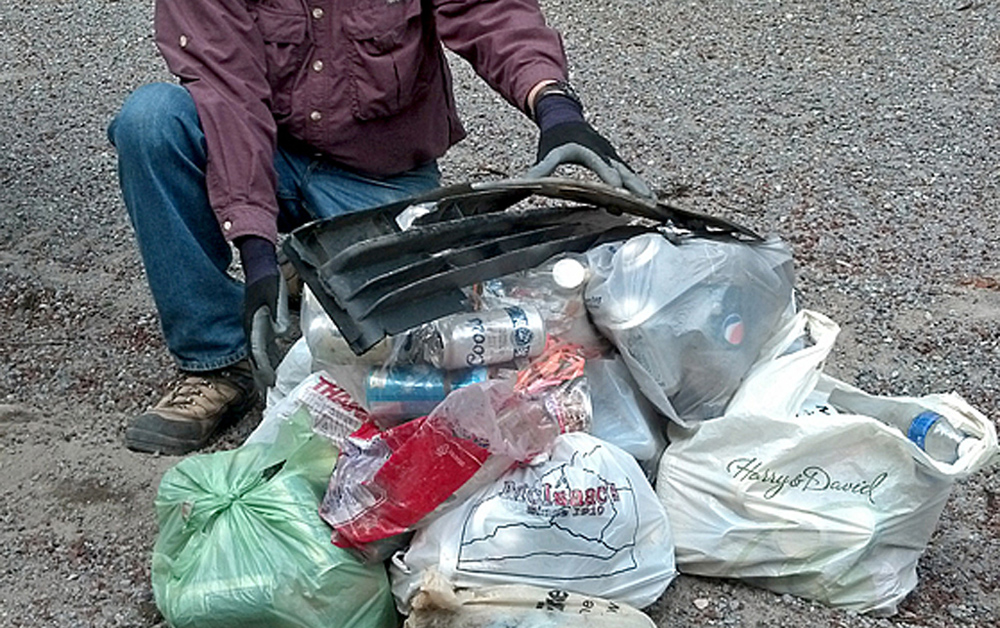
Trail trash: Record numbers of adults are behaving like three year olds. The rest are left holding the bags. Photo by Jurgen Hess

Seriously, what is wrong with people?

Does restricted social movement due to COVID-19 really make a portion of the population feel they’re entitled to use our public lands as a giant garbage can?

You already know the answer.

But the U.S. Forest Service (USFS) and Washington Department of Fish and Wildlife (WDFW) are dishing out the dismal details.

“Excessive trash and littering challenges have approached a crisis level of concern at recreation sites throughout the Columbia River Gorge,” said the USFS in a press release last week. “During a time when resources and staffing capacities are stretched thin, keeping up with maintenance, cleaning and trash removal has proved problematic during record high visitations in 2020.”

WDFW followed up with its own cry for help in the face of a recreating public that acts with less discretion than zoo animals.

“Increased use (of public lands) has caused a pileup of trash, human waste and unauthorized activity at a number of locations around the state,” according to a WDFW Facebook post. “As one Eastern Washington access manager noted, in past years they could fill up four bags of litter in one week, but ‘this year I’m lucky if I don’t fill up four bags in a day.’”

Dumping garbage in campground toilets? Apparently that’s a thing now.

[perfectpullquote align=”full” bordertop=”false” cite=”” link=”” color=”” class=”” size=””]One challenge is people are leaving behind masks, which you might not want to pick up.[/perfectpullquote]

The adults who need to be trained to act like half-civilized 10-year-olds are almost certainly not reading this story. So it falls to the rest of us to pick up the slack by picking up the trash when we see it.

I started by hauling candy wrappers, chunks of plastic and a pile of discarded pistachio shells off the top of Sleeping Beauty peak in the Gifford Pinchot National Forest this week.

But even this kind of old-fashioned civic decency is being made tougher by sign-of-the-times refuse.

“One challenge is people are leaving behind masks, which you might not want to pick up,” says Friends of the Columbia Gorge communications director Burt Edwards.

Rather than asking its members to wrangle potential biohazards—to say nothing of those plastic bags of dog piles owners bag up then inexplicably just leave on the ground—the organization is reiterating its message to observe pack-it-in-pack-it-out protocol.

Through a partnership with Ready, Set, GOrge!, numerous agencies are collaborating on a public outreach campaign called “Let’s Talk Trash” to highlight current garbage-related struggles and ways to help.

Preaching to the choir? Probably. But someone’s gotta do something.

Chuck Thompson is the editor of Columbia Insight.

By |2025-12-03T15:02:42-08:0008/05/2020|Features, Opinion|2 Comments

Thermal hopscotch: How Columbia River salmon are adapting to climate change

‘Cold water refuges’ are increasingly crucial for migrating salmon and steelhead. But what exactly are they?

Coho salmon

Seeking shelter: Salmon migrating through the Columbia River Basin have never had it easy. Now the annual spawning epic has become even more perilous. Photo by BLM

By Chuck Thompson. July 23, 2020. Water in the Columbia River Basin isn’t just getting warmer. In places it’s getting downright hot.

At the confluence of the Columbia and Yakima rivers in southeastern Washington, for instance, summer water temperatures have been recorded as high as 90 F (32.2 C).

Blame dams, levees and other concrete additions to the river. And, of course, climate change.

All salmonids—chinook, coho, sockeye, steelhead—suffer if the water they live in spikes above 68-70 F. Anything above 70 F (21 C) increases stress and the likelihood of fatal diseases.

In water above 74 F (23.3 C) salmon stop trying to swim altogether. At that point, many will die.

Swimming in warm water requires fish to expend fat stores and burn more energy than they otherwise would.

As a result, by the time they reach spawning grounds, gonadal functions may be impaired or fish may simply be too exhausted to spawn.

So what’s a migrating salmon or steelhead to do when confronted with a warming Columbia River?

What is a ‘cold water refuge’?

For salmon and steelhead moving up the Columbia River in summer—when water temperatures above 70 F are now commonplace—the answer to an increasingly inhospitable river lies in a relatively recent behavioral adaptation.

In growing numbers, salmon and steelhead have begun seeking relief in small pools of cool water. These pools form at points where mountain rivers and creeks feed into the Columbia.

Scientists call these areas of naturally occurring thermal relief “cold water refuges” or CWR. They’re sometimes referred to as “thermal refuges,” “thermal sanctuaries” or simply “refugia,” but each term describes the same thing.

Arranged by river mile, the EPA’s list of all 23 cold water refuges on the lower Columbia River. The Cowlitz River is the largest by total volume. The 12 primary CWRs are highlighted in color. Courtesy EPA

Get used to that acronym. CWRs have become critical pit stops for migrating fish. Chances are you’re going to be hearing a lot more about them.

“These refuges are really telling about the way adult salmon are using habitat in the Columbia,” says Margaret Neuman, executive director of the Mid-Columbia Fisheries Enhancement Group, in Ellensburg, Washington. “There’s this idea that they’re hopscotching up the river from cold-water input to cold-water input.”

Dashing dozen

Researchers became aware of the importance of CWRs in the Columbia River in the 1990s. Studies led by teams from the University of Idaho in the early 2000s established the current baseline of scientific knowledge about them.

But a 176-page EPA report due at the end of summer 2020—the Columbia River Cold Water Refuges plan—will shed light on just how crucial CWRs have since become to salmon and steelhead survival.

The report is certain to become the touchstone document for assessing CWRs in the Columbia River.

In the lower Columbia—the stretch from its mouth at the Pacific Ocean to its confluence with the Snake River some 325 miles upstream near the Oregon-Washington border—EPA researchers assessed 191 sources of water input into the Columbia.

Of these 191 tributaries, just 23 qualified as CWRs—meaning the water they drain into the Columbia flows at high enough volume and significantly colder temperature to make a localized impact.

Of these 23 CWRs, 12 were identified as “primary” CWRs.

Primary CWRs are unevenly distributed. Past the Deschutes River (the most easterly green dot) fish find little relief. Courtesy EPA

How important are these 12 primary refuges? Collectively, they constitute 97% of the total CWR volume on the lower Columbia River.

The two largest are located at the mouths of the Cowlitz River (river mile 65) and Little White Salmon River (river mile 159), which empties into Drano Lake prior to entering the Columbia River. Both rivers are in Washington. (See map above for location of all 12 primary CWRs.)

Perhaps the most astonishing find by researchers is the way salmon and steelhead are altering historic patterns of migration to dash from CWR to CWR on their way to upriver spawning grounds.

“During the peak CWR use period—late August-early September—we estimate that 80-85% of the steelhead in the Bonneville Reach between Bonneville Dam and The Dalles Dam are in CWR, which is 0.2% of the total volume of water in this reach,” says John Palmer, senior policy advisor at the EPA Region 10 office in Seattle and the new CWR study’s primary author.

In other words, when temperatures are warm the majority of migrating fish aren’t even bothering with most of the Columbia anymore. They’re simply seeking out rare breaks from its punishing heat and regrouping before racing to the next refuge.

Adaptive research

Although the current vernacular isn’t widespread, “cold water refuges” have always been a feature of river hydrology.

So how do researchers know salmon and steelhead along the Columbia haven’t always sought out CWRs as R&R stops along their grueling journeys?

“The Columbia historically wasn’t as warm as it is now,” says Palmer. “Summer temperatures were about 2-to-3 degrees Celsius less, so it didn’t get to the temperatures that we know trigger refuge use. The University of Idaho (studies) found that at 19 C some fish use them, but when you get to 21 C you have almost 70% of steelhead moving into cold water refuges.

“At 21-22 C, those are thresholds the science says fish want to escape that water. Putting two and two together we concluded the amount of use we see today is an adaptation to the warmer river. The evidence is highly suggestive that’s what’s happening.”

Enough cold water left?

Starting in the 1930s, dams and the slackwater they produce have warmed summer temperatures in the Columbia River by about 2 degrees Fahrenheit, according to the EPA. Climate change has additionally warmed the river by a little more than 2 degrees Fahrenheit.

Conditions will get worse. Across the Columbia River Basin the trend is warmer water.

“There’s only so much cold water,” says Palmer. “It gathers in winter and spring but slowly gets flushed out of the system (as summer progresses).”

So, given current models are there enough CWRs to accommodate the needs of migrating fish?

In the lower Columbia, probably so.

High heat: Fed by tributary creeks originating from elevations of up to 8,000 feet in the Malheur National Forest, the John Day River is still too warm at its confluence with the Columbia to provide thermal refuge. Photo by BLM

East of the Cascades, however, rivers and streams flowing into the Columbia are generally warmer. That’s where the situation gets dire.

“We’re still examining the question,” says Palmer. “There are no refuges above the Deschutes River (river mile 201). So fish have to go from there past the John Day Dam up through the 76-mile John Day Reservoir. It’s the warmest stretch of the river and there’s really nothing there for them to escape those temperatures.”

During hot summer months, between the John Day Dam and McNary Dam (river mile 292) there are no CWRs at all. In warm years the river here can average 72 F (22 C) in August. The 10-year average is 70.7 F (21.5 C).

Just below the McNary Dam, the Umatilla River can be considered a CWR only after late August and September, when it begins to run slightly cooler than the Columbia.

The Umatilla would need substantial upstream restoration to reestablish flow and lower its temperature before it could supply meaningful thermal refuge to fish in the hottest weeks of summer.

Waters begin to cool, if gradually, after the Columbia’s northward bend into Washington and eventually British Columbia.

From fire to frying pan

CWRs might sound like a welcome relief for salmon and steelhead. But any benefits they derive from CWRs are mitigated by a massive drawback.

CWRs don’t just attract fish. They attract fishermen.

“Fishermen know these areas because that’s where fish go. But they don’t refer to them as ‘refuges.’ They call ‘em ‘fishing holes,’ right?” says Palmer.

Refugia researcher: EPA’s John Palmer. Courtesy of John Palmer

Fish in a kettle is an apt analogy. There’s a reason large CWRs, such as Washington’s Drano Lake, attract commercially guided fishing expeditions from as far as Yakima. Anglers know their chances of landing fish increase in compact areas where fish cluster.

A 2009 study found migration success among steelhead that used CWRs was about 8% less than steelhead that didn’t use them. Fishing in CWRs explained the decreased survival rate.

It’s a cruel twist for migrating species. Fish are seeking cool refuges; in response, humans have made these refuges even more dangerous than the warm waters fish are so desperate to escape.

Palmer stresses the purpose of the coming EPA report is to provide information, not suggest mitigation efforts.

“We’re not in the fish-regulation business, we’re in the water-quality business,” he says.

Nevertheless, the agency’s forthcoming report will likely inform future conservation strategies.

“People in the salmon recovery world doing projects in these tributaries can help justify a project by saying, ‘Well, not only are we going to increase spawning and rearing habitat in the tributaries but it’s helping to cool the water, which will have a beneficial effect down river.’ People doing projects will think about this as an objective,” says Palmer.

Management policies have already been influenced by the evolving significance of CWRs.

Hot spot: Salmon and steelhead seek relief in the cool waters of Drano Lake. Fishermen await. Photo by Jurgen Hess

In 2020, the Oregon Department of Fish and Wildlife closed all fishing during warm months at what the department calls “thermal sanctuaries” at the mouths of Eagle Creek, Herman Creek and the Deschutes River. The closures are in effect from July 15-September 15.

The EPA’s report could help build a case for more protections around CWRs.

Enhancement projects

Although cold water refuges occur naturally, efforts to enhance them are popping up around the Columbia River Basin.

The Portland-based Lower Columbia Estuary Partnership (LCEP) is currently in the assessment phase of a thermal refuge enhancement project at the confluence of Oneonta and Horsetail Creeks on the lower Columbia River.

“The concept is to construct one or more diversion structures that will promote expanded cold water plume formation by diverting warmer Columbia River water away from the confluence zone,” says LCEP physical scientist Keith Marcoe.

Feature attraction: A manmade alcove in the bank helps retain cool spring-water at the Yakima River Mile 25 Thermal Refuge. Photo by Eric McCrea

In 2019, near Benton City on the Yakima River, the Mid-Columbia Fisheries Enhancement Group (MCFEG) reconnected a small, cool groundwater spring to the river. It’s likely the Yakima River Mile 25 Thermal Refuge is the first such enhancement project on the river.

Coupled with downstream projects currently in development, the goal is to capitalize on critical sources of cool water in what the organization calls a “very hot portion of the Yakima River.”

“The spring is already naturally there; we’re trying to maximize how much positive impact it’s having on the river,” says MCFEG executive director Neuman. “We basically dug a little alcove into the bank …and added wood and planted trees along the spring area to try to keep the water cool. We installed (structures) to hold the spring-water back, just not let the spring-water all run off at once, but try to modulate it a little bit.”

A beaver has since settled in the area—beaver ponds can enhance cold water refuges—but it’s too soon to gauge the project’s long-term impact.

Manmade CWRs?

Such small-scale interventions lead to a broader question: are large-scale manmade cold water refuges possible?

Although created unintentionally, artificial CWRs already exist along the Columbia River.

Government Cove, where Herman Creek spills into the Columbia River just east of Cascade Locks, Oregon, was created when small islands in the river were artificially joined. The result is a protective barrier that collects and delays the flow of cool water from Herman Creek before it empties into the mainstem of the Columbia.

“It wasn’t built to be a cold water refuge but it’s turned into that,” says Palmer. “The cold water stays there for a while, and fish go into it.”

By far the largest and most used refuge, Drano Lake, east of Stevenson, Washington, is another unintentional refuge. The lake was created when a dike was built at the mouth of the Little White Salmon River to accommodate railroad tracks, and later State Highway 14.

“That already is kind of an artificial CWR,” says Palmer. “So it’s not impossible to think about doing some of this.”

How much help, really?

Among some environmentalists, CWRs are increasingly seen as an important piece of salmon recovery strategies.

Is that hope misplaced? Is human enhancement of CWRs a too-little-too-late solution to the Columbia’s epic problems?

“From our perspective, the problem with temperature in the Columbia and Snake is that the whole river is too hot,” says Miles Johnson, senior attorney for Columbia Riverkeeper. “I don’t mean to say that cold water refuges are not important and worth protecting. But the lower Snake and lower Columbia are too hot for salmon and steelhead and it’s dams and reservoirs and climate change (causing the problem).”

The implication is only large-scale solutions can fix the large-scale problems in the Columbia and Snake.

Steelhead standard: Oregon DEQ defines cold water refugia as “those portions of a water body where … the water temperature is at least 2 degrees Celsius colder than the daily maximum temperature of the adjacent well mixed flow of the water body.” Photo by Jurgen Hess

Especially considering their vulnerability to fishing, Palmer admits the overall value of CWRs is “a big question.” But he’s more bullish on their role.

He points to a modeling study conducted at an EPA lab in Corvallis, Oregon. In a theoretical Columbia River in which all CWRs were removed, the simulation showed stress levels in salmon and steelhead more than doubled.

“In the lower Columbia the salmon have told us cold water refuges are helpful for them; it’s mitigating the warmer Columbia,” says Palmer. “I don’t think they would be going into cold water refuges if there wasn’t some benefit there.”

Chuck Thompson is editor of Columbia Insight. Additional reporting by Valerie Brown.

By |2020-10-15T09:30:16-07:0007/23/2020|Climate Change, Salmon, Water|4 Comments

Opinion: ODFW’s new climate change policy changes nothing

The Oregon Fish and Wildlife Commission’s new policy may indeed be an ‘historic action’—it has more to do with the past than the future


Specter vision: Absent genuine action, climate change means wilderness fires will become even more devastating. Photo by Jurgen Hess

By Chuck Thompson. July 16, 2020. For anyone comforted by last week’s announcement that the Oregon Fish and Wildlife Commission has adopted a trailblazing new climate change policy, here are two words—don’t be.

Calling itself “the first state fish and wildlife commission in the nation to adopt such a measure,” ODFW heralded its “historic action” as the kind of government stroke desperately needed as the planet warms and wildlife copes with environmental duress.

In reality the proclamation is 2,825 words of finely tuned bureaucratic prose and admin non-speak.

There’s a pledge to develop a plan with a goal for ODFW operations (facilities, vehicles, equipment, etc.) to become carbon neutral by some unspecified point “mid-century.” And a call for better coordination with other state agencies and stakeholders.

Otherwise, the department’s Climate and Ocean Change Policy presents little that is new.

And not a single specific action for battling the great existential crisis of our time.

The policy has been in the works for more than two years but its release coincides with another attention-grabbing state dictum on climate change.

As a response to Governor Kate Brown’s March 2020 Executive Order on Climate Action—EO 20-04 directs state agencies to reduce and regulate greenhouse gas emissions—the Fish and Wildlife Commission policy reads more like it’s designed to fulfill an organizational mandate than it is to protect the environment.

Calling yourself a leader doesn’t make you one

ODFW’s Draft Climate and Ocean Change Policy begins by acknowledging, “Earth’s climate and oceans are changing because of activities that emit greenhouse gases into the atmosphere.” 

That’d be a nice place to start in 2006, the year An Inconvenient Truth was released. Or even 1988, the year the Intergovernmental Panel on Climate Change was established by the United Nations to formulate response strategies to climate change.

Firmly stating a belief in climate change in 2020 feels a little quaint. And the circumspect tiptoeing around the fact that “human” activities are contributing to climate change (the word is carefully avoided) is similarly behind the times.

Regardless, in no fewer than six places the document asserts ODFW will assume a “leadership” role in the state’s fight against climate change. Yet it outlines no plan for doing so.

Instead it’s filled with obfuscating rhetorical doozies indigenous to breakout room ideation sessions: “Management goals, strategies, and actions will consider (the) long view, but allow for near-term conservation, utilization, or transition in an adaptive management approach.”

Fine, but isn’t that what ODFW and just about everyone else is already doing—worrying about the future while acting in the interests of the present?

With apologies to fish and wildlife

If ODFW’s announcement of the new policy is meant as a balm for public concerns it isn’t helping.

Neither are sections that address wildlife management.

Policy: “The ability to utilize fish and wildlife for harvest or viewing is dependent on the health of wild populations. Conservation and use are not mutually exclusive, and can be fully integrated through risk management that scales use appropriately to avoid undermining conservation.”

Translation: “Whatever environmental problems arise in the future, we’re gonna keep on hunting and fishing.”

That’s not a serious climate change policy. That’s a defense of the status quo.

Looking tough: Audubon climate models predict burrowing owl could lose 77% of their breeding range. The owls are a species of concern in Oregon and Washington. Photo by Jurgen Hess

Other sections offer an even more dismal view of the department’s leadership vision for climate change.

Acknowledging that “in some instances … the impacts of climate change and ocean conditions are practically irreversible,” the draft document states ODFW will prioritize conservation actions for species with the best chances for surviving habitat change.

It goes on to say it will “assign lower priority to actions where projected habitat changes caused by climate and/or ocean change are likely to exceed native species’ ability to persist.”

Given warming water temperatures across the Columbia River Basin and overall worsening conditions for ocean-going species, one could fairly interpret that last line as a future rhetorical defense for raising the white flag on the protection of salmon and other anadromous fish species.

It’s easy to imagine the quote from some as-yet-unborn mid-century ODFW manager: “Hey, sorry about all the fish, it’s state policy adopted in 2020, there’s nothing we can do.”

We’re on our own

To be fair, the Fish and Wildlife Commission doesn’t have magic powers. It alone can neither institute nor enforce the kinds of foundational changes in public attitudes, commercial practices and governmental regulations needed to reverse the effects of climate change.

In Oregon most wildlife habitat is managed by federal agencies (U.S. Forest Service, BLM), state land managers (state parks, forests), local governments and a lot of private landowners with divergent interests.

The department is simply too entrenched in the prevailing system to disrupt it in any meaningful way.

Furthermore, it’s not realistic to expect a committee-crafted document to make a genuine difference in environmental problems as massive as the ones facing the Columbia River Basin.

[perfectpullquote align=”full” bordertop=”false” cite=”” link=”” color=”” class=”” size=””]ODFW’s new policy reinforces a reality we simply need to live with—government isn’t getting us out of this mess.[/perfectpullquote]

To its credit, ODFW says it’s simply trying to be assess the future through a realistic lens.

“We don’t have unlimited resources as a state or as a department,” Davia Palmeri, ODFW conservation policy coordinator, told Columbia Insight, saying the intent of the policy is intentionally “very high level and very conceptual.”

“The science is clear we will be in situations where no action we take will be able to solve the issue that a species is facing,” she said. “We want to acknowledge that’s a real possibility. And get ready to have that conversation and recognize this will be a conversation that happens within that context. The policy sets up the ability for that conversation to happen but does not predetermine the outcome of that conversation.

That may be accurate but a policy that merely sets the stage for future tough decisions feels like kicking the climate change can down the road yet again.

In the end, all this “first in the nation” policy does is reinforce a reality we simply need to live with—despite trumpeting claims of leadership, government has neither the will nor the means to get us out of this mess.

If the climate is going to change in the direction we want, it’s up to us to make it happen.

Chuck Thompson is the editor of Columbia Insight.

By |2025-12-03T15:03:42-08:0007/16/2020|Climate Change, Opinion|3 Comments

Monarchs are disappearing. A native plant holds the key to their recovery

Friends for life: Monarchs and milkweed adapted to each other for survival. That relationship is more important than ever. Photo by Stephanie McKnight/Xerces Society

By Sue Kusch. July 9, 2020. The first time I noticed a milkweed plant I was cruising down a Forest Service dirt road on my way to a hiking trail. I braked quickly and backed up—common behavior for plant enthusiasts.

Standing alone in a ditch, the three-foot-tall stalk was topped by a large pink and white flower. It seemed so unusual I was certain it must be a rare species.

I grabbed my newly purchased wildflower guide, brushed off the layer of road dust on the leaves and flower and sat down to begin my identification effort.

New to the world of native plants, I was chastened to discover the plant I’d identified as milkweed was far from rare. In fact, it belonged to a genus of more than 100 species.

The diverse number of species live in a corresponding diversity of landscapes: wetlands, desert, mountain meadows, fields, open woodlands, along rivers and other sunny spaces of undisturbed land.

Free weed: A variety of wild milkweed species are native to the Columbia River Basin. Photo by Stephanie McKnight/Xerces Society

Milkweeds are grown commercially (mostly east of the Rocky Mountains) and used to make a variety of products: the seed floss is used in floating cleanup kits for oil spills and as a hypoallergenic filling for pillows and winter clothing.

The seed pods contain oil and wax, which are mechanically extracted and pressed into a rich oil commonly used in moisturizers. The de-fatted seeds are ground into a meal and used to kill nematodes and armyworms.

A broad range of milkweed species is native to the western United States.

“In the Columbia Basin, the most common species are showy milkweed, narrow-leaf milkweed and swamp milkweed,” says Stephanie McKnight, conservation biologist with the Portland-based nonprofit Xerces Society for Invertebrate Conservation. “Pallid milkweed occurs in the Columbia Basin but is rare.”

Evolutionary match: Milkweeds and monarchs

During the last three decades, milkweeds have commanded public attention because of their unique relationship to the monarch butterfly.

Milkweeds serve as the only host plant for the monarch butterfly caterpillar: a single egg is laid on the underside of a milkweed leaf. Once the egg hatches into a caterpillar it begins to feed on the leaves.

Named after the Greek god of healing, Asclepius, the common name, milkweed, is a reference to the milky secretion, called latex, found in the stems and leaves. That latex contains cardiac glycosides, a bitter-tasting chemical compound that can be toxic to some birds and other species when consumed.

The monarch caterpillar has developed the ability to sequester the latex and utilize it as a protection against its own potential predators, such as birds and mice, which spit out what they hoped would be a tasty meal. Evolved over millennia, this relationship serves as a classic example of co-evolution: a relationship in which plants and animals create adaptations to each other for their survival.

“The reason monarchs are so brightly colored is milkweeds are toxic,” says Scott Hoffman Black, executive director of the Xerces Society. “As monarch caterpillars eat the milkweed they concentrate those toxins in their bodies and become unpalatable. Basically that bright orange and black color tell birds, ‘That doesn’t taste good, I’m not going to eat that.’”

Tough spot: Monarch caterpillars on milkweed are increasingly rare. Photo by Stephanie McKnight/Xerces Society

Milkweeds have developed an additional strategy to dissuade predators.

“In milkweed plants, the latex is stored under pressure, so that when the leaves are broken—either by one of us as we pass by and pluck a leaf, or by the caterpillar that bites into the leaf, that latex exudes with some force,” says Dr. Anurag Agrawal, author of Monarchs and Milkweeds: A Migrating Butterfly, A Poisonous Plant and Their Remarkable Story of Co-Evolution.

Toxic latex aside, the plants remain appealing to an array of animals.

“Milkweed plants provide habitat for a variety of insects—butterflies, moths, bees, wasps, flies, true bugs, beetles, spiders, ants, mantids and lacewings to name the most common,” says McKnight. “Some of these are pollinators.”

But there’s a problem with both monarchs and milkweeds.

Monarch butterfly populations are dwindling. Alarmingly.

And while milkweeds remain prevalent in the Columbia River Basin, native species face increasing pressures from the development of subdivisions and commercial areas. Pesticides use in agricultural and suburban zones also destroys milkweeds and habitat crucial to monarch butterflies and other pollinators.

“There’s over-grazing in the Columbia River Basin, and there’s a lot of highly toxic insecticides used in agricultural areas,” says Black. “But looking at U.S. Geologic Survey data, urban and suburban areas often have as high or higher levels of pesticide use. It’s not just a matter of pointing a finger at a farmer.”

Natural wonder under threat

Each fall, monarch butterflies migrate from summer habitats in the Columbia River Basin to overwintering grounds. Though some will make it as far south as Mexico, the vast majority will arrive at overwintering grounds in California, stretching from coastal locations around the Bay Area as far south as San Diego.

“If you’re talking about monarch butterflies in the Columbia River Basin, you have to talk about California,” says Black, adding that loss and degradation of overwintering sites in California results in fewer monarchs migrating north.

“We’ve gone from likely around 4.5 million monarchs in the Northwest that overwinter in California (in the 1980s) to this last year around just 30,000,” says Black. “That’s a pretty drastic drop.”

[perfectpullquote align=”full” bordertop=”false” cite=”” link=”” color=”” class=”” size=””]You’re not imagining it—monarch butterflies really are disappearing.[/perfectpullquote]

Part of broader monarch movements in the West—which stretch from Canada to Mexico—the butterflies’ migration is one of the world’s great natural wonders. That wonder is now in crisis.

“In the winter of 2018, and again in 2019, the western monarch overwintering population has reached the lowest level ever recorded—less than 1% of historic populations, and a dizzying 86% drop from the year prior,” according to the Xerces Society.

In March, Xerces reported the number of monarchs spending the 2019-20 winter in Mexico had fallen by 53% over the previous year.

“Monarchs are not recovering and still urgently need Endangered Species Act protection in the United States and extraordinary conservation efforts,” said the organization.

Will enough habitat remain?

Without plentiful milkweeds in seasonal breeding areas, monarchs aren’t able to reproduce in significant numbers.

Monarch Watch is a nonprofit conservation and research program based at the University of Kansas that focuses on the monarch butterfly. Its Monarch Waystation project encourages planting patches of milkweed native to each region “in home gardens, at schools, businesses, parks, zoos, nature centers, along roadsides and on other unused plots of land.”

The Western Monarch Milkweed Mapper, a community science project with multiple partners managed by the Xerces Society, is focused on collecting data from citizens living in western regions on sightings of both monarchs and milkweeds.

Resilient not indestructible: Over-grazing is one of a number of practices that threaten milkweed habitat. Photo by Stephanie McKnight Xerces Society

In the Columbia River Basin, Black says better stewardship of existing milkweeds habitat is the most effective way to protect or restore monarch populations.

“I’ve been trying to steer these conversations to ‘let’s protect what remains in natural areas, on roadsides, on U.S. Forest Service or BLM lands,’” he says. “It doesn’t hurt to go out and plant milkweeds. But it’s harder and more expensive to do restoration than protection.

“Milkweeds are vital in the Columbia River Basin for monarchs. We need a diversity of native milkweeds across these landscapes … if we lose milkweeds in the Basin we’re not going to have monarchs.”

The Monarch Waystation and Western Monarch Milkweed Mapper projects offer simple opportunities to participate in conservation efforts for both the eastern and western populations.

If nothing else, Robert Pyle, lepidopterist, Xerces Society co-founder and author of Chasing Monarchs, reminds us that milkweeds are more than just a pretty flower.

“Our milkweed species, while patchy and limited in their Washington occurrence, comprise a valuable and significant component of our flora,” Pyle has written. “Both showy and narrow-leaved milkweed are superb nectar plants for an array of other butterflies as well, and for many other pollinators.”

As for the monarchs, if they’re to bounce back in the West, milkweeds will be the key.

A former college educator and adviser in Vancouver, Washington, Sue Kusch cultivates edible, medicinal and native plants. She currently serves as president of the Suksdorfia Chapter of the Washington Native Plant Society.

‘Big day for Oregon’: Legislature unites to pass major Forest Bill

Not just cutting: A routine part of logging operations is spraying herbicide on private forest land to reduce vegetation competing with new forest, making trees grow faster. This helicopter is spraying near Days Creek, a tributary to Woods Creek, in the Oregon Coast Range. Photo courtesy Beyond Toxics by Francis Eatherington

By Chuck Thompson. July 6, 2020. On an October morning in 2013, a Gold Beach, Oregon, woman named Kathryn Rickard was puzzled by the continuous droning of a helicopter passing at low altitude over her neighborhood. She stepped outside to assess the commotion.

“Immediately I was assaulted with a horrible, horrible smell,” Rickard later told Jefferson Public Radio. “My sinuses were burning, my eyes were burning, I got a rash all over my arms. I felt sick to my stomach.”

Rickard had been hit with a chemical herbicide being sprayed over a nearby logging operation.

Almost seven years later, Rickard’s experience and subsequent complaints has led to the Forest Aerial Spray Bill (SB1602), passed by the Oregon Legislature in an overwhelming bipartisan vote on June 26, 2020.

Once signed into law by Governor Kate Brown, the forest bill will strengthen the state’s aerial pesticide spray regulations.

Key provisions of the new forest bill include expanding no-spray buffer zones around fish and drinking water sources; making no-spray buffer zones around homes and schools five times wider, from 60 to 300 feet; and requiring companies to give 24-hour notice to nearby residents before spraying operations begin.

As important, the new law provides a foundation for broader reforms to the outdated Oregon Forest Practices Act, according to the Crag Law Center, which helped negotiate the agreement that led to the passage of House Bill 1602. Passed in 1971, the oft-amended Oregon Forest Practices Act set standards for logging practices, including applying pesticides and replacing harvested trees, and building and maintaining roads.

Environmental groups approve

The result of a long, contentious and costly negotiation between at least 13 environmental and fishing groups and 13 timber companies, passage of SB1602 was immediately cheered by environmental groups.

“We applaud (the) affirmative vote because it establishes a lasting policy of community pesticide right-to-know, as well as protective no-spray buffer zones for homes and schools, as well as drinking water intakes,” said Eugene-based Beyond Toxics in a press release. “For the first time in Oregon’s history, SB 1602 sets no-spray buffer zones for small streams and tributaries.”

[perfectpullquote align=”full” bordertop=”false” cite=”” link=”” color=”” class=”” size=””]The bill’s passage is a milestone on the road to cleaner water and healthier salmon runs.[/perfectpullquote]

“This is a big day for the state of Oregon,” said Sean Stevens, executive director of Oregon Wild. “This legislation is a down payment on bringing our forest laws into the 21st century and finally turning the myth into reality—that Oregon has strong laws that protect our forests and communities.”

“Today is another milestone on the road to cleaner water, safer communities and healthier salmon runs,” said Bob Van Dyk, Oregon and California policy director for the Portland-based Wild Salmon Center. “This validates the hard work by conservation and fishing groups to hammer out a deal with timber companies. And it shows broad, bipartisan consensus that it’s time to modernize Oregon’s forestry practices.”

Arduous effort rewarded

Following Rickard’s 2013 experience in Gold Beach (during which her husband and dog experienced similar symptoms) and a 2014 Oregonian investigation into pesticide spray complaints, Senator Michael Dembrow of Portland and former Representative Ann Lininger of Lake Oswego co-sponsored aerial pesticide spray legislation in 2015.

The battle for passage was arduous.

A major breakthrough came in February 2020 when representatives from both sides signed a Memorandum of Understanding. The MOU pledged both sides to pursue a “science-informed policy development process, rooted in compromise” lest competing initiative petitions appear on the November 2020 statewide ballot.

Passage of SB1602 eliminates that possibility and vindicates years of tenacious effort.

“They’re hoping that if they pass something, we’re just going to go away,” said Rickard in 2015 about an early, watered-down version of a reform bill that irked activists. “Unfortunately, that’s not going to happen.”

“Rickard promises she and other advocates for tougher spraying rules will be back next session to push for more,” reported Jefferson Public Radio in 2015.

Rickard and many others kept their promises. Oregonians are now safer because they did.

Major acquisition nets Columbia River tribes new clout

Saline solution: Pacific Northwest tribes have assumed stewardship of the Center for Coastal Margin Observation and Prediction, which tracks water quality in and around the Columbia River Estuary. Photo by Charles Simenstad, University of Washington 

By Chuck Thompson. June 25, 2020. The freshwater plume that discharges from the Columbia River into the Pacific Ocean around Astoria, Oregon, is an ever-changing phenomenon. Near the Columbia River Estuary at the mouth of the river it may be mostly freshwater; as it expands into the Pacific it becomes brackish; in places it might be a 50-50 mix of fresh- and saltwater; eventually ocean water overtakes it completely.

During heavy flow periods in spring the plume can extend 100 miles offshore at its outermost edge and as far south as Newport, Oregon. In fall, it’s a more localized feature around the mouth of the river, and can spread like a narrow jet along the Washington coast less than 10 miles from shore.

Winds and the Coriolis effect also impact its position.

Linked to salmon survival, water conditions in the estuary are vital to the health of the entire Columbia River Basin. But it’s a tricky thing to study.

As of this month, the primary research operation monitoring the flow and chemistry of waters in the Columbia River Estuary and offshore areas has a new overseer.

On June 1, the Oregon Health & Science University (OHSU) officially transferred operational control of the Center for Coastal Margin Observation and Prediction (CMOP) to the Columbia River Inter-Tribal Fish Commission (CRITFC).

The eye-glazing alphabet soup of acronyms notwithstanding, it’s a massive and significant deal.

For CRITFC, acquisition of the nationally renowned CMOP builds on a growing capacity for world-class research. The center collects and analyzes estuary data that informs everything from Columbia River Treaty negotiations to industrial dredging operations to salmon recovery strategies.

MORE ON CI: Revitalizing wetlands in the Columbia River Estuary

“This is a tremendous capacity-building advance for the Columbia River tribes,” says CRITFC chairman Jeremy Red Star Wolf. “Our professional river and salmon management staffs have wanted more ocean and river connectivity in research, applied science and management. CMOP will help deliver that.”

CRITFC coordinates management policy and provides fisheries technical services for the Yakama, Warm Springs, Umatilla and Nez Perce tribes.

“So often the general population’s perception of tribes are either that they’re caught in the past or are just about fishing,” says CRITFC spokesman Jeremy FiveCrows. “People have no idea we’re doing this much primary science. In co-managing this resource, we’re managing at the same level as state and federal agencies.

“Our Hagerman Genetics Laboratory (in Idaho) is one of the foremost fish genetics labs in the whole country. Adding CMOP, a primary science source, under the umbrella of a tribe, can really change peoples’ ideas of who tribes are today.”

What is ‘coastal-margin science’?

CMOP acquires data through a network of observation stations and buoys, many equipped with radio telemetry. (Some stations are currently inactive due to coronavirus-related restrictions.) Underwater “gliders” that roam the coast also collect data.

The network ranges from points offshore as far up the Columbia River as Camas-Washougal, Washington.

Research staff use computer models to verify and expand the scope of observations. All data are publicly accessible and used by federal, state and tribal agencies. The information is also used by fishers, shipping companies, aquaculture businesses, weather forecasters, public utilities, search-and-rescue teams and others to make informed operational decisions.


Deep dive: Remote-controlled underwater drones (“gliders”) collect water samples at varying depths and use sensors to measure chemical and biological conditions of ocean water. Photo coutesy CMOP

CMOP calls its primary pursuit coastal-margin science.” Numerous organizations and academics conduct research in transitional aquatic environments. But the study of these critical near- and offshore zones isn’t traditionally recognized as a single discipline in the way of oceanography or limnology, the study of bodies of freshwater, such as rivers and lakes.

According to its own website, “CMOP is creating a new paradigm for conducting coastal-margin science. It is anticipatory rather than reactive, and is based on an information-rich environment where sensors, models and people all generate and freely share information. We call these integrations ‘collaboratories.’”

“One of the important things we do is long-term observation,” says CMOP coordinator Charles Seaton, who is making the transition from OHSU to CRITFC. “A lot of scientific research tends to be more focused on a specific question you want to answer. You put out instruments and do observations for a week or a month or a year and get data to answer a particular question you are interested in.

“For understanding the long-term health of the system and being able to see what changes there are, for instance as climate change progresses, you have to observe constantly for a very long period of time. You can’t say the estuary has become saltier if you don’t know what the variability of the estuary is like over the long period. You really have to be watching for decades to see that that’s happening and be able to predict how it will go in the future.”

Bridging a ‘balkanized’ river

CRITFC has worked closely with CMOP for more than a decade. By 2018, when the idea for CMOP integration with CRITFC was first raised, the organizations had a tight connection.

“We are proud of the work that the CMOP team has accomplished and are confident that CRITFC will continue to sustain and expand this mission in the future,” said Daniel L. Marks, senior associate dean for research in the OHSU School of Medicine in a press release. “We believe that the momentum and trust built during this collaborative transfer process will serve as a model for ongoing collaboration with CRITFC and tribal communities.”

Station master: CMOP’s observation network includes devices attached to offshore buoys and fixed positions. Icon colors indicate station status: purple for seasonal; green for real-time; red for offline; blue for self-recording; brown for low-priority; gray for historical. Image from CMOP website

According to Chuck Hudson, CRITFC director of government affairs, one of CMOP’s primary remits is to serve as a bridge between river and ocean knowledge and agencies.

“In the Columbia Basin you have a very balkanized, massive watershed that spans two countries and seven states,” says Hudson. “All sorts of different jurisdictions and agencies are often charged with conflicting mandates—say, irrigated agriculture, river navigation or forest work.

“CRITFC has done some of its best work in breaking down the balkanization … but we still find Columbia Basin politicians and mangers and responsible parties throwing their hands up and saying, ‘It really doesn’t matter what we do in the rivers, it’s all ocean conditions.’ Or ‘The ocean is just this big black box, we don’t know what’s going on. What does it matter what we do here in the Columbia River?’

“The ocean has become an easy scapegoat to diminish responsibility for things we try to do in the river. Our program managers have been asking for capacity to better link Columbia River science and management and knowledge with ocean knowledge and management systems. … CMOP appears to us to be that perfect link to bridge those two knowledge and management areas.”

Following the fish

CMOP funding is primarily allocated through the U.S. Department of Commerce. Funding flows through various partner entities, including the National Oceanic and Atmospheric Administration, the U.S. Integrated Ocean Observation System and Northwest Association of Networked Coastal and Ocean Observing Systems.

The Portland-based Meyer Memorial Trust provided a $350,000 tribal science capacity-building grant to CRITFC to help facilitate the transfer of CMOP from OHSU.

Although CMOP headquarters will be moved from OHSU in Southwest Portland to CRITFC offices in Northeast Portland, physical operations will continue to be based in Astoria.

MORE ON CI: Landowners take FERC to court in hopes of blocking LNG pipeline

“The health and wellbeing of Oregonians starts with a healthy environment,” said Dr. Antonio Baptista, longtime CMOP director and a retiring professor at OHSU, in a press release. “CMOP developed, for the Columbia River Estuary, the tools and culture needed to build scientific consensus on sustainable development under a changing climate. As natural stewards of the Columbia River, the tribes are in an outstanding position to expand and bring a centuries-long perspective to what we started decades ago.”

“Our co-management ethos dictates that wherever the salmon go, we go with them,” said CRITFC executive director Jaime A. Pinkham. “We intend to maintain the current capacity of the program and use it as a new beginning alongside public and nonprofit partners to bring tribal co-management and vision in the estuary and ocean environments.”

© Copyright 2013-2025 Columbia Insight. All Rights Reserved.

As a 501(c)3 nonprofit organization, all donations to Columbia Insight are tax deductible to the full extent of the law. Our nonprofit federal tax-exempt number is 82-4504894.