Stay Updated Subscribe today for the latest research + reporting about environmental news. Subscribe Now

Stay Updated Subscribe today for the latest research + reporting about environmental news.

Subscribe Now

Kendra Chamberlin

Kendra Chamberlin

Kendra Chamberlain

About Kendra Chamberlain

Columbia Insight contributing editor Kendra Chamberlain is a freelance journalist based in Eugene, Oregon, covering environment, energy and climate change. Her work has appeared in DeSmog Blog, High Country News, InvestigateWest and Ensia.

Oregon hopes to expand one of the last wetlands habitats in Willamette Valley

Proposed land acquisitions near Eugene are part of a settlement between the Bonneville Power Association and State of Oregon

Fern Ridge Wildlife Area Near Eugene, Oregon

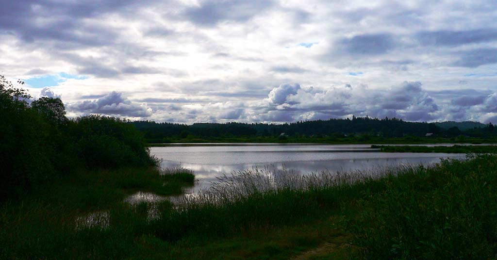
Limited edition: The Fern Ridge Wildlife Area is a popular birding area. Photo: Rick Obst/Flickr

By Kendra Chamberlain. October 23, 2024. Acre by acre, the state of Oregon is protecting what’s left of the wetlands habitats that were once abundant in the Willamette Valley.

The Oregon Department of Fish and Wildlife (ODFW) is proposing to acquire three parcels of land near Coyote Creek outside the city of Eugene to add to the Fern Ridge Wildlife Area (FRWA).

The FRWA encompasses nearly 6,000 acres of riparian, wetlands, wet and upland prairie habitat.

Wetlands habitats, which are some of the most biologically diverse habitats in the state, were once dominant through the Willamette Valley. They have become nearly non-existent thanks to agricultural and urban development in the valley.

According to some estimates, only 8 square miles of wetland remains in the valley.

The biggest chunks of that habitat—composed of wildlife areas managed by state and federal agencies—form a chain stretching along the western side of the valley and in floodplains along the Willamette River.

The Fern Ridge Wildlife Area is one of those precious blocks of habitat. This makes the management area significant to wildlife that depend on it.

It hosts at least 289 species of birds, 49 species of mammals, 19 species of fish and 22 species of reptiles and amphibians.

It’s home to the state’s largest breeding population of purple martins, and hosts one of the largest breeding populations of western pond turtles in the region. Tundra swans, white pelicans, beavers, foxes and bobcats, bats, Pacific chorus frogs, rubber boas (a native species of constrictor snakes) and a unique population of cutthroat trout that migrate between the Fern Ridge Reservoir and the Long Tom River, also inhabit the space, along with endangered species such as the Fender’s blue butterfly and Kincaid’s lupine.

Purple martin, male

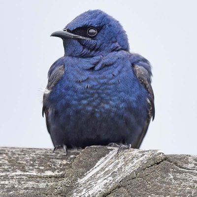
Colorful neighbors: The purple martin (this male was photographed in western Washington) is among many species that depend on the Fern Ridge wetlands. Photo: VJAnderson/Wikimedia Commons

The majority of the Fern Ridge Wildlife Area is owned by the U.S. Army Corps of Engineers and is managed by ODFW. ODFW has also acquired more than 600 acres of adjacent land to manage as part of the FRWA.

The three parcels of land proposed for acquisition are adjacent to ODFW-owned land and would add 222 acres of conservation habitat to the FRWA.

The land acquisitions are part of the wider Willamette Wildlife Mitigation Program, created through a 2010 settlement agreement between the Bonneville Power Association and the State of Oregon.

The land acquisitions would help fill in some of the jigsaw puzzle gaps between existing FRWA parcels, according to Justine Brumm, interim program coordinator of the Willamette Wildlife Mitigation Program at ODFW.

“Habitat connectivity and adjacency to Fern Ridge Wildlife Area are key reasons that these particular properties have been prioritized for acquisition,” Brumm told Columbia Insight. “All three of the properties fall within a Priority Wildlife Connectivity Area identified through ODFW’s Oregon Connectivity.”

Most of the land is already riparian, wetlands or upland prairie habitat.

Some has been converted to agricultural land, which ODFW plans to restore to native habitat.

If the deal goes through, the new parcels would result in two miles of contiguous Coyote Creek riparian habitat being protected, and would better link the FRWA to Coyote Prairie, a nearby wildlife reserve owned by the City of Eugene.

The land acquisitions aren’t a done deal yet.

The Oregon Fish and Wildlife Commission will vote on the proposal in December. If approved, the deals are expected to be complete by September 2025.

By |2026-01-13T12:57:00-08:0010/23/2024|Land Use|1 Comment

A rare water collaboration is overcoming regulatory obstacles. And benefitting fish

Water users in Washington and Oregon are working together to keep streams flowing in the Walla Walla River Basin

Walla Walla River

Crossing the line: Here experiencing flooding in 2020, the Walla Walla River originates in Oregon but joins the Columbia in Washington. Photo: Wikimedia Commons

By Kendra Chamberlain. October 17, 2024. Conserving water across state lines is no easy task.

Last year—for the first time ever—Washington was able to enroll an Oregon surface water right, held by the Washington City of Walla Walla, into the state’s Water Trust Program, ensuring minimum stream flows throughout the summer in Mill Creek to ensure fish migration.

An important tributary of the Walla Walla River, Mill Creek Watershed is Walla Walla’s primary source of water. It has been federally identified as having insufficient stream flow and high water temperatures, both of which severely limit access for summer steelhead and bull trout to upstream habitat.

It’s taken decades of work to get to this point, according to Brook Beeler, Washington Department of Ecology’s eastern regional director.

“In the Walla Walla watershed, the Oregon-Washington state line has long been recognized as a barrier to managing water supply and instream flows for the benefit of fish,” Beeler told Columbia Insight via email.

The Walla Walla River begins in the foothills of the Blue Mountains in Oregon, and flows north across the Oregon-Washington border before turning west to the Columbia River. The basin’s rivers and streams flow through both states.

Walla Walla Watershed

Walla Walla Watershed. Map: Marc Nelitz/ESSA Technologies

European settlers developed the area into an agricultural hub of fruit orchards, alfalfa seed, onions and wine grapes—sucking up massive amounts of water in the process.

According to the Department of Ecology, water rights in the basin have been over-allocated for more than a century. Annual agricultural diversions have left streambeds dry, contributing to the extirpation of salmon.

In 2000, irrigators from Oregon and Washington settled an agreement with U.S. Fish and Wildlife Service to leave water in the Walla Walla River through the dry summer months. But there was no mechanism to save that water from being legally diverted once it crossed state lines into Washington.

“After decades of water planning, a new approach was deployed by both states, the Confederated Tribes of the Umatilla Indian Reservation and local stakeholders to develop a 30-year strategy to improve streamflows and maintain sustainable water supply,” said Beeler.

The Walla Walla Water 2050 Plan was released in 2021, outlining a bi-state water management approach to coordinate efforts to protect minimum stream flows. This summer, the first out-of-state temporary surface water right was enrolled into the trust.

There were hiccups along the way, including a faulty gauge led to an over-diversion of water into Mill Creek, leaving streamflows in nearby Yellowhawk Creek unusually low.

But as the first foray into bi-state water management, the summer of 2024 marked an unprecedented achievement in the Pacific Northwest.

By |2026-01-13T13:01:32-08:0010/17/2024|Rivers, Water|1 Comment

Why are Republicans so opposed to a new groundwater study?

With wells running dry and groundwater depleting at frightening rates, the federal government is growing concerned

Low flow

Low flow: A pressure gauge, which measures water pressure, in southern Oregon’s Klamath River Basin. Photo: Kimberley Hasselbrink

By Kendra Chamberlain. October 9, 2024. Republicans in the Pacific Northwest are spooked that the Biden Administration is investigating the country’s declining groundwater resources.

Six U.S. representatives, including Dan Newhouse (R-Wa), Mike Simpson and Russ Fulcher (R-Id) and Cliff Bentz (R-Or), declared their opposition to any attempts by the federal government to horn in on what they claim is purely a local matter: groundwater.

“It is not the role of the Federal government to manage or regulate groundwater,” the politicians say in a letter addressed to the President’s Council of Advisors on Science and Technology (PCAST). “As Members of Congress who represent rural and western districts, we staunchly oppose this effort to impede state, local, and Tribal regulatory authority.”

The Oct. 1 letter follows a similar missive sent by Idaho Gov. Brad Little and Lt. Gov. Scott Bedke to the Biden administration in late September.

The Republicans are responding to a query PCAST sent out in April, asking for public input on groundwater allocation issues across the West.

PCAST established a working group to focus on the issue earlier this year, a move that Republicans say signals that the Biden administration is angling for more say in groundwater management.

That may well be the case.

Groundwater is depleting at frightening rates across the country, including in the Pacific Northwest, and it’s not that clear states are doing a good job at conserving the resource.

This summer, for the first time, Idaho state officials were forced to curtail groundwater allocation for a short period. Oregon revised its groundwater rules after over a thousand wells ran dry across the state.

It’s no secret that sprawling development and often-unchecked agricultural practices have depleted or contaminated groundwater aquifers across the West.

Groundwater reservoirs don’t recharge quickly. In fact, the water being pumped from deep underground is likely hundreds to tens of thousands of years old.

“We are effectively mining that water, and that creates a sustainability challenge overall,” Upmanu Lall, director of the Columbia Water Center, explained during a public meeting on groundwater PCAST held in 2023. “If we use up that stock today, future generations won’t have it.”

Whose jurisdiction?

Conserving groundwater may require a more proactive approach than how states are currently handling the issue.

Groundwater depletions are localized events, but can impact entire economic sectors and, by proxy, the national economy, according to Lall.

U.S. Representative Dan Newhouse

Rep. Dan Newhouse. Photo: Office of Dan Newhouse

He pitched the formation of a national water strategy during the public meeting that would support local governments in conserving both surface water and groundwater using subsidies and grants.

As it stands now, PCAST is only collecting input from the public that’ll be used to develop a report to advance “government-wide action on groundwater.”

More information is a good thing, right? Not to everyone.

The Republican representatives say local water authorities have been left out of the process.

Rep. Newhouse told Columbia Insight in an email that he’s adamant that groundwater regulation is a state issue.

“While it’s not clear what their recommendations are or what the impacts to individual states will be, I sent a letter with a few of my Western colleagues trying to obtain more information and reiterate that groundwater is and should remain an issue left to the states,” said Rep. Newhouse.

By |2026-01-13T13:06:40-08:0010/09/2024|News, Water|5 Comments

In Idaho, a controversial mine gets green light despite major concerns

Federal law gives mining interests an advantage in determining the best use of public lands in the Stibnite mining area

Yellow Pine mine pit in Idaho

Dig it: The Yellow Pine mine pit in Idaho’s Stibnite Mining area in 2022. The area could once again be opened to mining. Photo: Nick Kunath

By Kendra Chamberlain. October 2, 2024. A proposal to build and rebuild open-pit mines in Idaho’s historic Stibnite mining district is moving forward, even as the U.S. Forest Service acknowledges it could have lasting, negative environmental impacts on the area.

The Stibnite mining district, located at the headwaters of the South Fork Salmon River, was critical to the United States’ war effort in the 1940s as a rich source of gold, silver, antimony and tungsten. Operations ended in the 1990s and the site was abandoned.

Perpetua Resources is hoping to reopen the mine, and resume extracting gold, antimony and silver. The Idaho-based company, formerly named Midas Gold, has been fine-tuning its proposal to the Forest Service for over a decade, as previously reported by Columbia Insight. [A previous version of this story incorrectly stated that Perpetua Resources is a Canada-based company, and that it had plans to open more mines in the Stibnite mining district. According to a Perpetua Resources spokesperson in an email to Columbia Insight, “Perpetua Resources has a single project and is not seeking to ‘build a few more.’” —Editor]

The proposal has faced significant opposition from the Nez Perce Tribe and groups like Idaho Rivers United, American Whitewater and Idaho Conservation League.

Last month, Forest Service released a final Environmental Impact Statement and a draft Record of Decision approving the mining proposal.

Activity in the historic mining district, located in the Payette National Forest and the Boise National Forest, decimated the local environment, notably blocking fish passage and polluting surface waters.

Opponents of the project say the area needs more environmental remediation, not more mining, to help restore protected fish species in the area.

Litigation expected

The Stibnite site is located next to the Frank Church-River of No Return Wilderness.

The area is also spawning habitat for bull trout and chinook salmon and includes treaty-reserved resources for the Nez Perce Tribe.

Stibnite Mining District map

Map: USFS


“The Forest Service is stuck in a hard place here,” Idaho Rivers United Conservation Director Nick Kunath tells Columbia Insight. “They need to do this analysis and are mandated to manage these resources, but they’re also governed by some incredibly old laws that essentially determined that mining was the best use of our public lands more than 150 years ago, and still have to treat these projects as such.”

The reference to “old laws” means the General Mining Law of 1872, which establishes hard rock mining as one of the most important uses for public lands in the United States.

Perpetua Resources’ proposal would nearly double the footprint of the existing mining site. But the company says it will remediate some of that legacy pollution, including restoring 450 acres of wetlands, filling in a mine pit and rebuilding sections of the river.

Still, the project is expected to have significant, long-term impacts on the surrounding environment.

The USFS draft decision notes that despite the mitigation plans promised by Perpetua Resources, the no-action alternative would be the “environmentally preferable” action.

The agency also conceded that water temperatures downstream of the mining site may be impacted if the modeled temperature mitigation measures do not work as hoped.

“When we look at even in the best case scenario that they’re really putting forward in this analysis, it’s more than 100 years before they think stream temperatures might come back to baseline levels,” says Kunath.

Opponents of the project are reviewing the draft decision and submitting objections.

The Forest Service will need to respond to those objections before releasing its final decision. Given the strong opposition to the proposal, it could be years before Perpetua Resources would be able to begin work.

“I can’t confirm if [Idaho Rivers United] is going to litigate—or anybody else—but certainly Perpetua expects litigation, and so does the Forest Service, with a project as controversial as this,” says Kunath.

By |2026-02-09T10:35:54-08:0010/02/2024|Conservation, Industry|1 Comment

Can photography save old-growth forests? David Herasimtschuk hopes so

An Oregon artist’s photo project is garnering national publicity by opening eyes to an often-invisible world

H.J. Andrews Experimental Forestin Oregon by David Herasimtschuk

Scaling down: Researchers survey for amphibians in H.J. Andrews Experimental Forest in Oregon’s Willamette National Forest. Photo: David Herasimtschuk

By Kendra Chamberlain. Sept. 25, 2024. When David Herasimtschuk first arrived in Oregon in 2011, he envisioned snorkeling with massive schools of salmon, in rivers surrounded by towering old-growth trees. But that’s not exactly what he found.

“After a few trips, reality hit hard—I realized I was probably 50 years too late,” Herasimtscuk tells Columbia Insight in an email. “While there were salmon, they were rare and infrequent, and the forests I walked through were nothing like the old-growth I had imagined.

“Instead, I found a patchwork of clear-cuts and second-growth, a shadow of the lush landscapes I had envisioned.”

Herasimtschuk, who studied wildlife biology at Colorado State University before turning to photography full time, is a few years into a long-term project to document remaining patches of older forests across the Pacific Northwest.

NPR recently highlighted Herasimtschuk’s work in an online article.

Herasimtschuk received a Vital Impacts Environmental Photography Grant for the project, which ultimately led to him pitching his project to NPR.

“This old-growth forest project is a long-term undertaking, and often self-funded, so I’m always looking for opportunities to help support the work,” says Herasimtschuk.

Rough-Skinned Newts_Oregon by David Herasimtschuk

Strong connections: Rough-skinned newts congregate around roots and branches in Oregon’s McDonald and Dunn Research Forests. Photo: David Herasimtschuk

His photographs capture the wonder of old-growth: giant living structures whose scale is only understood by the starkly diminutive size of humans that appear in the photographs.

Herasimtschuk’s photography de-centers humans, reminding us that the forests don’t exist for human benefit.

Some of his photography involves setting up his camera trap in a remote part of a forest. He sometimes leaves his gear out in the woods for long periods of time, hiking back to the spot and hoping he’s caught wildlife that may have wandered by.

Black Bear_Oregon by David Herasimtschuk

Happy trails: Herasimtschuk gets some of his best pics, like this black bear in Oregon’s Siuslaw National Forest, when humans aren’t around. Photo: David Herasimtschuk

Publicity he’s earned has helped raise awareness of old-growth forests and the intricate if underappreciated relationships within these ecosystems.

There’s one relationship in particular Herasimtschuk says he’s hoping to illustrate with photos: that between the Pacific Northwest’s threatened Oregon Coast Coho salmon and its old-growth forests.

Herasimtshuk calls the coho the “fish of the forest.”

Coho Salmon in Oregon stream

Streaming service: Coho salmon benefit almost every part of the forest. Herasimtschuk has put in countless snorkel hours to capture them in places like the Siuslaw National Forest in the Oregon Coast Range. Photo: David Herasimtschuk

“Few species teach us more about the connection between rivers and forests better than coho salmon. From headwaters to estuaries, these fish utilize a wide variety of habitats within these watersheds, and are intricately tied to the foundation and health of these ecosystems,” says Herasimtschuk. “After years of work, and countless river miles snorkeled, this last winter I was able to create a few images that start to show these fish in an impacted forest landscape.

“My hope is that images like these can help illustrate the impacts of forest management on fish, like coho salmon, and that logging still remains as a major limiting factor in the conservation of this federally protected species.”

Herasimtschuk’s photographs can be viewed at his website.

By |2026-01-13T13:31:15-08:0009/25/2024|Conservation, News|1 Comment

Does new video series mark a WDFW pivot toward conservation?

A social media charm offensive from the Washington Department of Fish and Wildlife touts the agency’s commitment to species biodiversity

Washington state species collage

Diversity equity: Washington is home to a spectacular array of species. The state is now actively appreciating them. Photo: WDFW

By Kendra Chamberlain. September 18, 2024. The Washington Department of Fish and Wildlife wants you to know that it cares about biodiversity.

A new initiative at the department is pushing back against its reputation as a “hook and bullet” agency, more concerned with managing revenue-generating game species than protecting ecological systems.

Scrolling through the department’s social media channels, you’d be hard pressed to find much conservation content—it’s largely orange vests, rifles and dead animals.

But for the first time in years, WDFW has a big biodiversity conservation budget.

Now it’s released a splashy new video series highlighting the state’s eight ecoregions, designed to be pushed across social media channels to generate buzz about conservation work at the department.

“Video is increasingly the currency in capturing people’s attention—particularly online—and getting them excited about something,” Margen Carlson, conservation director at WDFW, tells Columbia Insight. “And we haven’t often had the funding capacity to do that work.”

Now they do.

The state legislature gave the department $24 million in funding for 2023-25, with an expected additional $17.2 million per biennium anticipated through 2029.

A chunk of that money will go toward implementing the State Wildlife Action Plan (SWAP) and building up new programs focused on recovering at-risk species and restoring habitat.

Sixty thousand dollars of the money earmarked specifically for conservation education and outreach went toward the video series.

Carlson says the ecoregion videos were filmed with an eye toward connecting people to place, and linking conservation efforts to specific geographies.

“We wanted to use the ecoregions, because those are both meaningful scientific descriptions of the different ecosystems … but they’re also meaningful differences across the state that you can really see,” says Carlson. “So we wanted to use a map that really bridged science and helps people see themselves in the places that they care about.”

Pivotal point?

Biodiversity is a goal of the state wildlife department that doesn’t typically get a lot of funding.

Much of the revenue generated by WDFW goes directly to game species research, monitoring and management.

Biodiversity work, on the other hand, has been chronically underfunded, according to a progress report from the department filed earlier this year.

“This biodiversity funding marks a turning point in closing the gap on implementing critical conservation actions to restore biodiversity in Washington,” the report states.

The biodiversity funding package garnered the state national recognition, and it came with what some sportsman groups feared was a mandate to reform the department toward more conservation.

“Washington legislators handed WDFW $23 million for new biodiversity work in the recently passed 2023-25 state operating budget, but they also snuck in an unsettling proviso requiring the agency’s governance, mandate and more to be reviewed and possibly reformed, enraging sportsmen’s groups,” wrote Northwest Sportsman in 2023.

A sizable chunk of that funding will support the state’s update to SWAP. The conservation plan is part of an effort across all 50 states to proactively address species declines and habitat loss before they’re too far gone.

Carlson says the department will release a public survey in the coming weeks to gauge public interest in conservation efforts. The update will be finalized next year.

“It’ll be a great opportunity for people to tell us what they think about in their place and what’s important to them, at the early stages [of the SWAP update process],” says Carlson. “One of our biggest goals right now is to facilitate people’s involvement in conservation efforts. And that can look a lot of different ways, at a lot of different scales.”

Videos in the series can be viewed on YouTube.

By |2026-01-13T13:35:25-08:0009/18/2024|Biodiversity, Conservation|5 Comments

© Copyright 2013-2025 Columbia Insight. All Rights Reserved.

As a 501(c)3 nonprofit organization, all donations to Columbia Insight are tax deductible to the full extent of the law. Our nonprofit federal tax-exempt number is 82-4504894.