Stay Updated Subscribe today for the latest research + reporting about environmental news. Subscribe Now

Stay Updated Subscribe today for the latest research + reporting about environmental news.

Subscribe Now

Chuck Thompson

Chuck Thompson

Chuck Thompson

About Chuck Thompson

Chuck Thompson is editor of Columbia Insight.

Wildfires pose dire threat to toxic Superfund site in Montana

Blazes around an imperiled hazardous waste site in Libby could release asbestos-laden toxins in smoke that would spread for miles

OU3 firefighters in Montana

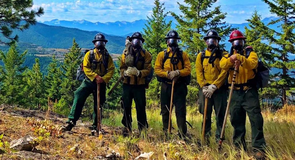
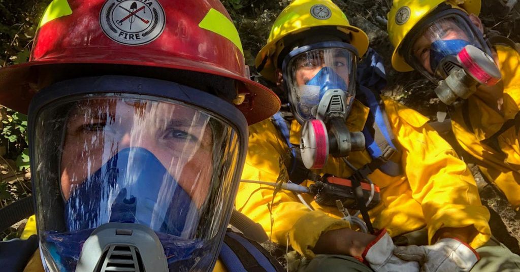
Protecting the protectors: Firefighters near the Libby Asbestos Superfund site in Montana wore respirators to protect them from asbestos contaminating the tree bark, soils and duff of the forest. More than 400 people in the area have died of asbestos-related diseases. Photo courtesy of Nolan Buckingham

By Michael Kodas and David Hasemyer, InsideClimate News. January 7, 2021. For Jake Jeresek, a leader of the U.S. Forest Service’s firefighting operation in the Kootenai National Forest of northwest Montana, blazes in the woods 4 miles east of the town of Libby demand the most urgent response. But, before his crew can snuff any flames in those woods, they must recite a poem.

“When the sunlight strikes raindrops in the air, they act like a tiny prism and form a rainbow,” crew members intone in turn.

The poem is a test of the firefighters’ respirators—a piece of safety equipment required in no other forest in the nation. The verse’s vocalizations ensure the respirators are properly sealed to the firefighters’ faces. 

Contaminated by Libby amphibole, a highly toxic mixture of asbestos fibers unleashed by a former mine that has killed hundreds of area residents, this section of forest is an officially designated hazardous waste zone—Superfund Operable Unit 3 of the Environmental Protection Agency’s Libby Asbestos Site.

With wildfires heightened by climate change threatening 234 Superfund sites across the country, according to the federal government, the OU3 Libby Asbestos Site presents a kind of worst-case scenario in which a wildfire could send asbestos-contaminated ash into nearby communities. Some firefighters worry a plume of smoke could carry the forest’s toxins hundreds of miles away. 

It’s one of the 945 Superfund sites that the Government Accountability Office last year found were vulnerable to hurricanes, flooding, sea level rise, increased precipitation or wildfires, all of which are intensifying as the planet warms.

A yearlong investigation by Inside Climate News, NBC News and The Texas Observer, based on interviews with dozens of current and former EPA officials and firefighting authorities, found that the threat presented by wildfires is exceeding authorities’ ability to adequately prepare and respond, given recent steep increases in wildfires, particularly in the West. Blazes at such sites could release toxins ranging from acid mine drainage to radioactive smoke.

Landscape ‘primed for fire’

Some firefighters and land managers fear that it is only a matter of time before megafires like those that exploded across Colorado and California this year burn over a toxic site with disastrous consequences. There have already been a number of extremely close calls.

In 2010, the 109,000-acre Jefferson Fire spread across the Idaho National Laboratory, a nuclear energy research facility, where it burned over Superfund sites that had been cleaned of radioactive contamination over the previous 17 years. The lab reported that sampling of the area during the fire showed no release of radioactivity. 

In 2013, the Patch Springs Fire southwest of Salt Lake City burned within 10 miles of the Tooele Army Depot, a Superfund site with 902 ammunition storage bunkers along with soil and groundwater contaminated with hazardous chemicals, according to Wildfire Today.

In 2018, the Carr Fire burned across 359 square miles of northern California and swept over the Iron Mountain Mine Superfund site, threatening to release corrosive chemicals into the watershed. The narrowly averted disaster spurred the EPA to reexamine the threat posed by wildfires to Superfund sites, especially old mines.

And in October, the Captain Jack Mill Superfund site, a closed mining operation in Boulder County, Colorado, was in the evacuation zone of the Lefthand Canyon and Calwood fires, but was spared when they burned away from the site.

Superfund sites vulnerable to wildfires

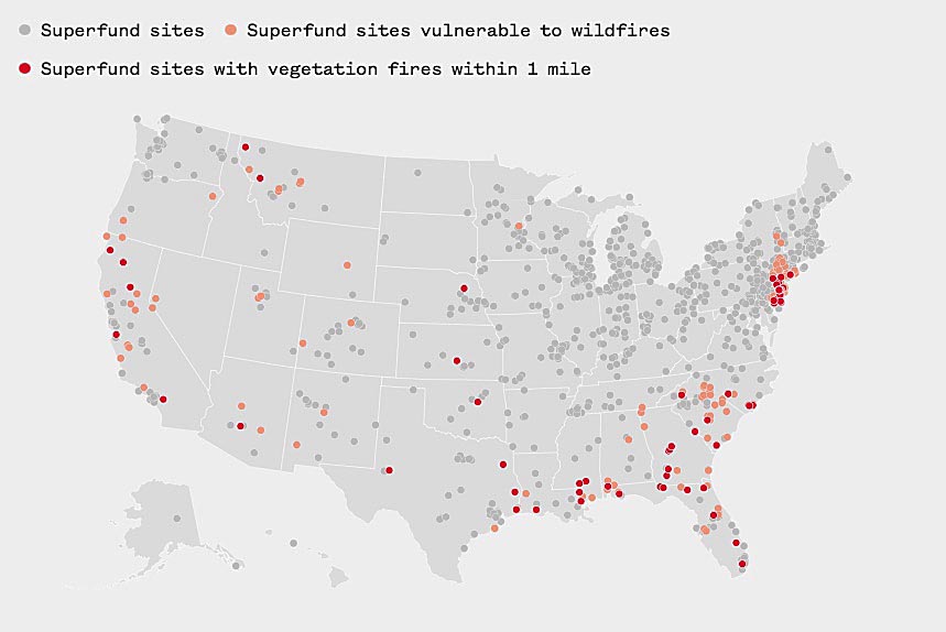
Vulnerable Superfund sites: Fire data is based on NASA and NOAA satellite infrared imaging and represents vegetation fires detected from June 2018 to May 2020. Cleaned-up Superfund sites are included on this map because, according to the Government Accountability Office, these sites may still contain contaminants after remediation is finished. Sources: U.S. GAO, NASA and National Oceanic and Atmospheric Administration. Graphic: Jiachuan Wu and Elliott Ramos/NBC News

In Montana, with five threatened sites, the temperature has warmed by 2.7 degrees over the past 70 years, substantially more than the nation as a whole, according to the 2017 Montana Climate Assessment. From 1970 to 2015, according to research published by Climate Central, that warming drove an at least tenfold increase in the number of wildfires larger than 1,000 acres in Montana, a greater percentage increase than in any other Western state. 

The Kootenai National Forest, which holds Libby’s asbestos-contaminated woods in the area known as OU3, endured its largest wildfire on record—the 25,000-acre Caribou Fire—in 2017. But that fire was some 50 miles away from the Superfund site. The following year OU3 faced a much closer blaze, the Highway 37 Fire, which firefighters held to just 71 acres. That fire burned just outside the boundary of the contaminated forest. 

“Climate change is driving increased severe, extensive fire behavior. We’re seeing more and more large, dramatic, destructive fires,” said Don Whittemore, a fire incident commander from Colorado who helped the Forest Service, EPA, state and county leaders put together their plan for managing fires in OU3. 

“They’ve had a bunch of large fires on the Kootenai and in northwest Montana in the last couple years,” he said. “I can say it’s a landscape primed for fire. It is set to burn. It’s ideal to burn.” 

Libby: A wakeup call

The Highway 37 Fire outside Libby started July 19, 2018, along the highway, where sparks and hot engines often lead to wildfire. Nolan Buckingham’s Asbestos Wildland Fire crew donned their respirators in case the fire crossed the boundary into the contaminated forest and were on the blaze in less than 10 minutes.

Given the extreme health hazards presented by a forest contaminated with highly toxic asbestos, there was no margin for error under extremely difficult conditions.

“That fire really put people out of their comfort level, even if it wasn’t in OU3,” Buckingham said.

As the fire roared uphill, the respirators made it hard for the firefighters to keep up. Luckily, a spot where the steep slope flattened out briefly a quarter mile up that hill gave them the break they needed. “We were able to catch it,” Buckingham said. 

[perfectpullquote align=”full” bordertop=”false” cite=”” link=”” color=”” class=”” size=””]“The amount of organic material that’s liberated from a large fire is extraordinary. Now, throw into that a cancer-causing material. To me, that’s really, really scary.” —Don Whittemore, fire incident commander[/perfectpullquote]

For the next several days, aircraft bombed the fire with water constantly as Buckingham and his team set up hoses and sprinklers and, at one point, burned away vegetation before the fire could get to it. Contractors with heavy equipment helped them build a fire line around the blaze. The fire was finally declared contained July 31. 

“We learned a lot from the Highway 37 Fire,” Nate Gassmann, the district ranger for the Kootenai National Forest, said, including strategies for containing fires and quickly decontaminating the crew members after their shift.

Still, when the contaminated forest’s fuel buildup and steep topography align with warm dry weather, Whittemore, the fire incident commander, said he worries the area could see far more than 70 acres burning. 

“Given the right alignment—50,000 plus acres in a day,” said Whittemore, who has studied OU3 in detail and led large firefighting teams across the West.

“It’s got the fuels. It’s got the topography. It just needs the weather alignment,” he said. “And if you’re cognizant and aware and thinking about climate change on a global, national, landscape level, it’d be irresponsible not to think that that’s a strong possibility. You have to plan for the worst-case scenario. Because more and more, we’re not only seeing worst-case scenarios, we’re seeing events that exceed worst-case scenarios.”

Planning for ‘potential impacts of climate change’

Two years before the Highway 37 Fire, Whittemore, the incident commander, read through the Libby Asbestos Response Plan and other documents that EPA had asked the Forest Service to prepare. He noticed little acknowledgement of what he’d been seeing in his decades fighting fires throughout the West—the warming climate was making fires larger and more resistant to suppression.

Whittemore said small test burns and fires in laboratory settings that have been conducted by those agencies don’t reflect what would happen with the asbestos, smoke and ash if a large, intense fire sent a smoke column from OU3 high into the atmosphere.

“The amount of organic material, period, that’s liberated from a large fire is extraordinary,” he said. “Now, throw into that a cancer-causing material. To me, that’s really, really scary.”

That smoke could affect communities far from Libby, he said.

“They didn’t appreciate downwind impacts to places like Whitefish, to Glacier National Park, across the border into Waterton National Park or other parts of Canada,” Whittemore said of the plans. He said he hopes a final cleanup study now underway will consider those areas far from Libby.

Aerial response to fire near OU3 in Montana

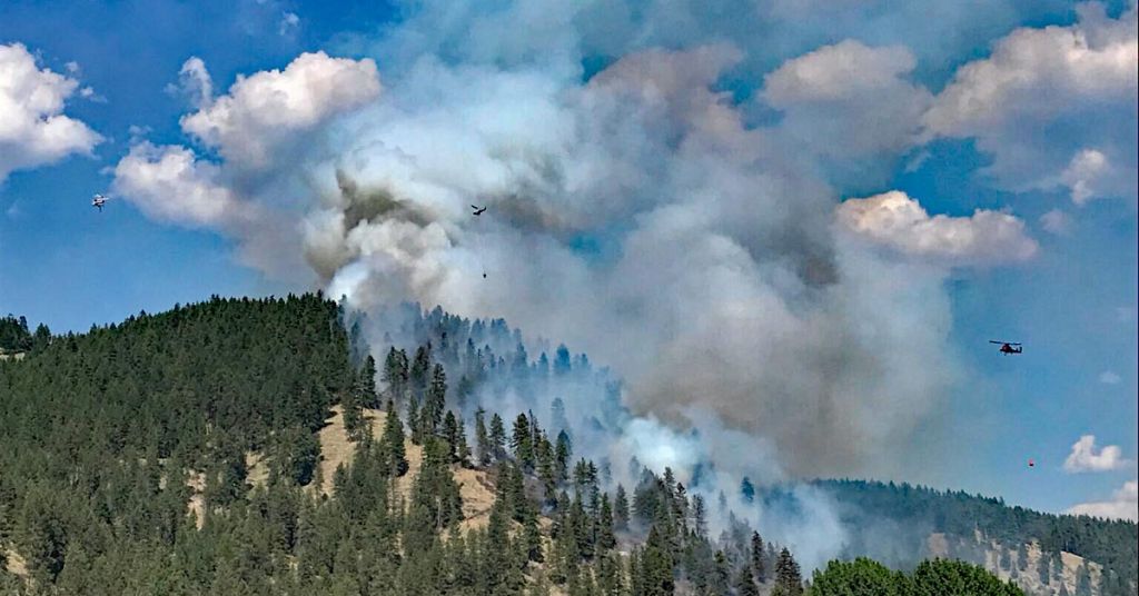
Toxic release: Aerial response to the fire near near Libby, Montana, was intense. The forest here is contaminated with highly toxic asbestos. Photo by USFS

More than two years after the Highway 37 Fire, the EPA, the Forest Service and the Libby Asbestos Superfund site’s owner, W.R. Grace & Co., are still working on a feasibility study of cleanup options, which was expected next year but has been delayed until late 2022 or early 2023. 

Libby’s asbestos-filled forest surrounds the mine where, until 30 years ago, W.R. Grace mined vermiculite, a mineral valuable in insulation and lawn and garden products. The vermiculite was also filled with Libby amphibole and tons of that asbestos were released every day from Grace’s operation, coating the miners, the town and the forest.

In 2008, Grace was ordered to pay $250 million for future cleanup costs. Several years earlier government prosecutors had brought criminal charges against company executives, who they claimed knew how deadly their operation was. The executives were acquitted and, in the years since, most of the Superfund operating units in and around Libby have been cleaned up. But Grace, the EPA and the Forest Service are still figuring out what to do with the asbestos-filled forest. 

While the EPA has not previously looked at the effects of a warming climate and increasing droughts on the threat posed by the contaminated forest, the agency will do so as part of the final cleanup study, Dania Zinner, the EPA’s remedial project manager for the Libby site, wrote in an emailed response to questions. “Ongoing discussions about potential impacts of climate change on the site, including fire behavior modeling, are continuing.”

Caitlin E. Leopold, director of corporate communications for Grace, said the company was working with the EPA on the plan for the forest.

“The Superfund framework does include climate change considerations as part of the process in accordance with the EPA,” Leopold said. “Grace is continuing to work through the feasibility process with the agencies.”  

Zinner said that the plan would consider the dangers posed to residents of Libby and beyond. “EPA and partners are considering any type of situation that could have an impact on human health risks at the site now and into the future,” she wrote.  

Recalculating wildfire threat

Entering this year’s fire season, officials in EPA Region 9, the region that includes California, Nevada and Arizona, updated fire contingency plans for remote Superfund sites, which are mostly abandoned mines.

“We also have been monitoring—and will continue to monitor—fire behavior closely to track threats to Superfund sites, as well as other sensitive infrastructure,” Michael Alpern, a spokesman for the region, said.

A spokeswoman for Shahid Mahmud, head of EPA’s National Mining Team, said that as a result of the more frequent and larger conflagrations, including the Carr Fire, cleanup plans for former mines are now designed with wildfires in mind. 

[perfectpullquote align=”full” bordertop=”false” cite=”” link=”” color=”” class=”” size=””]“We don’t have another 500 firefighters to call, we have the 20.” —Nathan Gassmann, Kootenai National Forest[/perfectpullquote]

Emergency protocols addressing wildfire threats are reviewed every year, and have become more urgent recently, the spokeswoman said.

But wildfire experts and climate scientists said that while it’s possible to reduce the threat, it’s not feasible to eliminate it. 

Mines will drain acid as long as their waters encounter sulphur-bearing minerals; radioactivity can persist deep in contaminated landscapes for thousands of years; and much of the asbestos in the contaminated forest outside Libby will remain there as long as the trees do. 

For sites where no polluter can be made to pay and the EPA lacks cleanup funds, the agency will need to design protections that shield the sites from wildfires as long as the contamination remains. And wildland firefighters and other emergency responders near Superfund sites in places like Libby will don their protective equipment, hold fire lines and hope they can prevent almost unfathomable environmental catastrophe. 

In Libby, can the forest ever be cleaned up? 

The contaminated forest in Libby surrounds the mine where, until 30 years ago, W.R. Grace mined vermiculite, a mineral that expands up to 30 times its size when heated, making it valuable as an insulation, soil conditioner and a fertilizer additive. 

The ore was filled with Libby amphibole, a particularly toxic combination of asbestos fibers. The plant that milled the vermiculite pumped out thousands of pounds of dust every day, between 20 and 40 percent of which was asbestos.

Dust coated the miners, came home on their clothes and drifted by the ton onto the nearby town. Residents insulated their houses and fertilized their yards with the asbestos-laced mineral. Leftover vermiculite was used in the track at the high school, baseball fields and local playgrounds. 

Since then, more than 400 people in Libby have died from mesothelioma, asbestosis, lung cancer and other diseases brought on by asbestos exposure. Thousands more have been sickened with the asbestos-related diseases that are almost always a death sentence. 

There is no safe exposure level for Libby amphibole and symptoms can take decades to arise, so physicians expect to be treating new cases for years to come.

After beginning an investigation into the spate of asbestos-related deaths in Libby in 1999, the EPA opened an office to oversee the cleanup there and requisitioned X-ray machines, devices to test lung function and other equipment to set up a medical clinic—an unheard of step for the agency. 

The EPA workers responding in Libby discovered not only far more lung disease than they anticipated, but also learned that their agency had produced repeated reports noting how deadly the asbestos in Libby was, yet had done nothing to warn the town. 

A year after it opened its office in Libby, three senior EPA officials made another rare move—requesting that the agency’s inspector general investigate how it had failed to protect the area’s citizens from a toxin it had known for decades was deadly.

‘Asbestos-laced trees’ are unique fire hazards

In the years since the $250 million settlement with W.R. Grace in 2008 and the subsequent acquittal of its executives on charges that they knew they were contaminating the town with deadly asbestos, most of the homes and contaminated sites in Libby have been cleared of the contaminated vermiculite.

But the forest surrounding the mine, where hundreds of tons of asbestos-filled dust fell, remains filled with the deadly fibers. 

The asbestos-laced trees present a unique hazard for Forest Service firefighters, only 20 of whom are trained and equipped with respirators to fight fires in Superfund Operable Unit 3. 

“We don’t have another 500 firefighters to call, we have the 20,” said Nathan Gassmann, the district ranger for the Kootenai National Forest. “We need to respond tactically, knowing we have that as a limitation.”

Those limitations include the respirators, which can make firefighters feel like they’re scuba diving in a forest. 

Jeserek, the Kootenai National Forest fuels planner who has been working with the respirators since the specialized firefighting program in OU3 began, said they leave firefighters at between 60 and 70 percent of their normal work capacity.

“Simple things like hiking become difficult,” Jeresek said. 

In addition to restricting firefighters’ ability to breath, he said, the masks limit their ability to see, hear and even smell—all senses firefighters depend on.

Highway 37 (Montana) fire crew members

Fire break: Nolan Buckingham (left) led a crew fighting the Highway 37 Fire outside Libby, Montana, that included Jaime Garcia and Aaron Turner. Photo courtesy of Nolan Buckingham

To help offset those challenges during times of high fire danger, the Forest Service positions a helicopter in Libby that can drop water on flames in the unit just a few minutes after they’ve been sighted. Other air resources prioritize OU3, too, so even tiny blazes around Libby receive extensive air attacks to make up for the lack of a critical mass of firefighters on the ground.

Most firefighters working deep in forests, where water is hard to come by, smother flames with dirt and contain blazes with firebreaks dug down to mineral soil, but in OU3 those techniques could fill the air with asbestos, so the primary firefighting tool there is water. Studies show wet asbestos has difficulty becoming airborne.

Whittemore, the wildfire incident commander, understands why every blaze in OU3 must be snuffed fast, but worries that its tiny crew of firefighters will eventually be outmatched. He has seen teams with hundreds of firefighters fail to contain an exploding wildfire.

“There will be a disastrous fire, period.” he said. “I think you’re irresponsible to look anywhere in the western landscape and not expect a disastrous fire could, will, occur there.”

In Libby, some residents doubt that the forest can ever be cleaned up.

“We discussed this 18 years ago,” said Gayla Benefield, an activist who led the fight to clean up Libby and hold Grace accountable for the contamination from its mine. “Most everyone that worked at the lumber mill got diagnosed. That’s what rattled everybody up there.”

Benefield recalls getting a Christmas tree from a nursery that stored its trees in one of the sheds near Grace’s mine. 

“The clouds of dust that blew off that thing as we drove it home on our car, I’ve never seen anything like it,” she said.

They rolled the tree in the snow outside their house to clean some of the dust off it before bringing it inside and decorating it.

Benefield’s parents and husband all died of asbestos-related illnesses, and she has had cancer three times herself. She said she wasn’t heartened by the research that showed less than 10 percent of the asbestos liberated in a fire in OU3 would travel in the smoke, or by the air quality monitors set up in Libby when wildfires burn there.

“Ten percent coming over the town is probably more than Grace itself put on the town,” she said. “They just can’t have a big fire anywhere here, especially in the forest around the mine. ”

Columbia Insight is publishing this story in collaboration with InsideClimate News, a nonprofit, independent news organization that covers climate, energy and the environment. You can subscribe to the ICN newsletter here.

InsideClimate News senior editor Michael Kodas is the author of Megafire: The Race to Extinguish a Deadly Epidemic of Flame, which was named one of the 20 best nonfiction books of 2017 by Amazon. He is the former deputy director of the Center for Environmental Journalism at the University of Colorado Boulder.

InsideClimate News reporter David Hasemyer is co-author of the Dilbit Disaster: Inside the Biggest Oil Spill You’ve Never Heard Of, which won the 2013 Pulitzer Prize for National Reporting, and co-authored the 2016 Pulitzer Prize finalist series “Exxon: The Road Not Taken.”

By |2021-01-07T12:15:20-08:0001/07/2021|Climate Change, Wildfire|9 Comments

Gray wolves removed from Endangered Species List

The move allows federal agencies to shift management of wolves to state agencies across Columbia River Basin

Gray wolf in snow by USFWS

Gray wolf: No longer endangered (officially), still embattled. Photo by Tracy Brooks/Mission Wolf/USFWS

By Chuck Thompson. January 6, 2021. On Monday, the U.S. Fish and Wildlife Service formally removed gray wolves in the Lower 48 states from the Endangered Species List. The decision was originally announced by the U.S. Department of Interior in October, which then said, “the Trump Administration and its many conservation partners are announcing the successful recovery of the gray wolf.”

Several conservation groups have since vowed to challenge the ruling.

“This is no ‘Mission Accomplished’ moment for wolf recovery,” said Kristen Boyles, an attorney with San Francisco-based Earthjustice. “Wolves are only starting to get a toehold in places like Northern California and the Pacific Northwest. … This delisting decision is what happens when bad science drives bad policy—and it’s illegal, so we will see them in court.”

This week’s formal implementation of the decision turns management of gray wolves over to state fish and wildlife agencies including those in the Columbia River Basin.

How many wolves in Columbia River Basin?

There is an estimated 6,000-plus gray wolves in the Lower 48 states.

According to the 2019 minimum wolf count, there are 158 known wolves in Oregon. These include 17 wolves in three packs in the state’s West Wolf Management Zone, and 141 wolves in 19 packs in the East Wolf Management Zone.

In Washington, the population of gray wolves is estimated at 145 in 26 packs, with 21 of those packs located in the eastern third of the state.

In early 2020, Idaho’s estimated wolf population stood at about 1,000 animals.

According to an Oregon Department of Fish and Wildlife press release, the major change from federal delisting is that under the state’s Wolf Plan, lethal control could be allowed in situations of chronic livestock depredation when non-lethal measures have been unsuccessful at eliminating conflict. Wolves are protected throughout the state. Hunting and trapping of wolves remains prohibited statewide.

“We thank all landowners in areas with wolves for going the extra mile to implement non-lethal measures over the past few years,” said Curt Melcher, ODFW director. “We know that regardless of whether or not you lose livestock to wolves, their presence requires changes to your business practices, and we thank you for taking these steps to reduce conflicts with wolves.”

In June 2020, the Washington Department of Fish and Wildlife said it was “currently developing a post-recovery plan to guide long-term conservation and management once wolves are delisted at both the state and federal levels.”

In 2020, the Idaho Fish and Game Commission opened more areas to wolf hunting and trapping and extended seasons for both activities.

By |2023-04-07T17:26:00-07:0001/06/2021|Wildlife, Wolves|1 Comment

2020: A better year than you think

Yes, there was plenty to complain about and almost as much to worry about. But people who care about the environment forged partnerships, made contributions and achieved breakthroughs worth remembering

Almost over: The most maligned year in memory did produce reasons to celebrate. Photo Jurgen Hess

By Susan Hess. December 24, 2020. We’ve—you and I—reached the end of year 2020. An accomplishment that feels like a hero’s journey. We swam the icy river, climbed the crystal mountain, crossed the burning sands.

Yet for all we as a society had to face, Columbia Insight had its best year ever, and that was due to the CI team: its board of directors, editors, technical consultants, writers, photographers and you, our readers and supporters.

This year that team’s intent was to be aware of what was happening with the pandemic, the endless political dramas, Black Lives Matter protests, wildfires, but still keep focused on our job, which is keep you informed about environmental issues affecting the Columbia River Basin.

When I was in college, my city planning professor asked our class, “Does politics affect city planning?” We were so naïve, so young. We sat there unsure. Of course, it is politics. Decisions political leaders make affect the environment we live in for good or bad.

Politics played a big role in our reporting this year.

Former CI managing editor Dac Collins wrote about a new rule that undercut the Clean Water Act. He wrote on the controversial compromises in the Owyhee Canyonlands proposed wilderness bill. Ben Mitchell reported on EPA’s decision to relax the enforcement of environmental rules. CI editor Chuck Thompson wrote about the Columbia River Gorge Commission’s decision to expand urban boundaries. Jordan Rane examined the U.S. Forest Service’s proposed elimination of some protections on large trees.

Compromise candidate: Oregon’s senators co-sponsored legislation to create 1.1 million acres of wilderness in the Owyhee Canyonlands. Photo by Greg Burke/ONDA

When the Black Lives Matter protests exploded across the country after the killing of George Floyd, Chuck Thompson searched for someone who could write about racial injustice in the outdoors and found Chad Brown.

Chad wrote from his own experience that for people of color in the Columbia River Basin, the simple act of taking a hike or casting a fishing line into the water can be weighted with danger. “We need equality. We need to be heard. We need a leader who hears the voices of pain. We need true allies and true action to make change,” Chad wrote. After we published his article, he was flooded with offers from you, our readers, to go fishing and hiking with him, and sending him speaking invitations.

We published 76 articles this year written by 35 journalists. The quality of their work brought an invitation to join AP StoryShare where CI’s articles were picked up by other news organizations like The Oregonian.

In March as Oregon and Washington governors issued closure orders to halt the spread of the pandemic, CI was in the midst of looking for an editor to replace Dac Collins, who was returning to Texas. Chuck Thompson stood out. He took over for Dac on May 1.

The editor sets the tone. The two men approached the job with different styles you see reflected in the articles they wrote and in how they guided the writers. But both shared a passion for the environment and for telling stories accurately and with zeal.

Perhaps that is shown most clearly in CI’s articles on wildlife, speaking for those who cannot speak for themselves, like Chuck’s op-ed “Did the Creswell bear need to be killed?” And in the beauty of his writing about the Basin’s warming rivers forcing salmon to race from one isolated “cold water refuge” to another: “Thermal hopscotch: How Columbia River salmon are adapting to climate change.”

At ease: For veteran Chad Brown relaxing in the outdoors isn’t always this simple. Photo by Chad Brown

One wildlife story was CI’s most read article ever and drew readers from across the country: “Inside a Washington community’s war on cougars” by Dawn Stover. That story was in the works for a year and half.

Thirteen-year-old London Fletcher speaks for the struggling orcas of Puget Sound. In a video produced by videographer Deb Bloom, London explains how the lack of chinook salmon that orcas need is exacerbated by four controversial dams on the Lower Snake River.

Jordan Rane investigated how wildlife is coping with 2020’s unprecedented wildfires. Like humans they fled, and returned to homes and habitat destroyed.

One factor that goes into our decisions on what issues to cover is how thoroughly (or not) other media are reporting on them. We looked at that in deciding to write minimally about this year’s massive wildfires. Jurgen Hess wrote about smaller fires in the hills above Mosier, Oregon, and the Trapper Creek Wilderness in Washington.

We think it’s important to report on the good as well as the bad. With its heartwarming video of a mama and kits, Jocelyn Akins’ article “Wolverines break through…finally!” is an example. Jocelyn’s enthusiastic reporting on the return of wolverines to the South Cascades made it CI’s second most popular story of the year, behind the piece about cougars in Klickitat County.

CI senior correspondent Valerie Brown’s story about the restoration of Steigerwald National Wildlife Refuge drew numerous requests for reprints. It was an inspiring piece in a dark time, as was a story by Jurgen about the Columbia River Estuary Study Taskforce’s restoration efforts in the Columbia River Estuary. Similarly, Dana Joseph wrote about Shepherd’s Grain, a company milling grain from product harvested using no-till methods, which farmers are employing to save soil.

Veterinarian Jean Cypher’s selfless dedication shines in Dac’s podcast, “Caring for wildlife at the Rowena Wildlife Clinic.”

Many stories don’t fit in a single category. “Oregon’s agricultural lands face off with the state’s growing urban population” by Valerie was an agricultural story and a climate story. That was one of the features that came from the support of Bob and Barbara Bailey. The climate stories this year came about thanks to the generosity of Eric and Cyndi Strid.

13-year-old London Fletcher

Whale watcher: 13-year-old London Fletcher is working to preserve orcas in Washington. Image by Deborah Bloom

CI is fortunate to have an outstanding Board of Directors, whose monthly input, guidance and expertise is reflected in the best of the work we do. Throughout the year, Chair Buck Parker’s steady leadership provides the kind of foundational confidence and knowledge every successful organization needs. Vice Chair Pat Case is no less a force of ideas and advice. Without Tracey Tomashpol’s tireless networking around the region our stories wouldn’t travel as far as they do. Same for Sonia Marquez, who leads our Spanish-language translation initiative. Jurgen Hess handles treasurer and secretary duties. With their experience and broad knowledge of business, energy, environmental and other issues, Kevin Ricks, Todd Lauble and Bob Bailey bring the kind of balance and deliberation that helps keep CI on track.

Who else made what we do possible? You. CI readers have contributed $5. $100. $7,000. Every donation counts.

It costs on average $1,000 to produce one story. Eight-four percent of CI budget goes to writers, editor, photographers. I draw no salary. Insurance, license fees and supplies all have to be figured in.

Then there’s technical consulting. A website like ours is amazingly sturdy and frighteningly fragile. It takes constant maintenance. The site is complex; the back end looks a bit like the console of a 737. Any new thing we want to do means we need someone who knows how to make it happen. I am grateful for our technical consultants Scott See, Holly Cate and Ross Thyer.

From our remote locations, the CI team is already at work on articles for 2021. Grants from the Society of Environmental Journalists are funding two series: one on air pollution in The Dalles, Oregon, and one on the impact of the Lower Snake River dams. The Collins Foundation is funding a series on environmental issues on Native American lands in the Columbia River Basin.

Your donations to CI this holiday season are being matched by NewsMatch, one of the many benefits of our membership in the Institute for Nonprofit News. We’re excited about the stories we have planned: like stories about the Cascades red fox, a video on the efforts of people at Warm Springs Indian Reservation working to solve the drinking water crisis and a collaboration with InsideClimate News on forestry.

In just days it will be 2021. The vaccine promises an end to the pandemic, but medical experts tell us there will be difficult months ahead before the virus is stamped out. Until then stay safe. We’ll be with you.

Susan Hess is the publisher of Columbia Insight.

By |2020-12-24T10:20:13-08:0012/24/2020|Opinion|1 Comment

10 biggest environmental stories of 2020

Twelve months ago murder hornets were as obscure as social distancing. Those weren’t the only surprises 2020 delivered

By Chuck Thompson. December 10, 2020. In what might have been the most improbable environmental moment of any other year in the Pacific Northwest, on May 20 a lone wolverine was spotted on Long Beach Peninsula on the Washington coast.

That was pretty cool. So was the February report that demolition of the infamous Plutonium Finishing Plant at the Hanford Nuclear Reservation in Washington had after 20 years finally been completed—the facility nicknamed “Z-Plant” produced two-thirds of the nation’s Cold War-era plutonium for nuclear weapons, and left behind radioactive and other highly contaminated materials.

But in a year that gave us everything from sheltering-in-place to a U.S. president hell bent on razing as many environmental protections as he could put an executive order to—yet who also signed the universally applauded, bi-partisan Great American Outdoors Act, permanently funding the Land and Water Conservation Fund and addressing backlogged maintenance at national parks—even that inspiring wolverine and end-of-an-era moment at Hanford couldn’t crack our list of biggest environmental stories of 2020.

Sockeye salmon/USFWS

In October, the governors of Idaho, Montana, Oregon and Washington pledged in a joint letter to work together to rebuild salmon and steelhead stocks in the Columbia River Basin. Great, but the decree lacks teeth and its impact remains to be seen. The governors acknowledged differences regarding conservation approaches and didn’t address this year’s federal government decision to maintain operations at four controversial dams on the lower Snake River that imperil salmon throughout the Basin.

MORE: Snake River Stranglehold series examines the environmental impact of dams on the lower Snake River

Sheriff Bob Songer/Klickitat County

In May, a lengthy feature in The New Yorker nosed into reactions of residents of Washington’s Klickitat County (population 22,425 in an area the size of Delaware) to the COVID-19 pandemic and “constitutional sheriff” Bob Songer’s apparent reluctance to enforce state-mandated shutdown orders. In September, in what would become Columbia Insight’s most widely read story of the year—drawing eyeballs from almost all 50 states and from Austria to Australia—we reported on a volunteer posse in the county killing at least 16 cougars Songer deemed a threat to public safety. A condensed version of that story will appear in the January 2021 issue of Men’s Journal magazine.

MORE: 16 and counting: Inside a Washington community’s war on cougars

BC Gov Photo (2019)

The veil of secrecy over ongoing U.S.-Canada Columbia River Treaty negotiations has made covering the talks difficult. On June 30, for example, the U.S. State Department and government of British Columbia surprised followers with a pair of press releases announcing June meetings between delegations from both countries. The light-on-details statements were surprising because few people even knew the tenth round of treaty talks, held via web conference, had already taken place. Lack of information doesn’t negate the importance of negotiations around a treaty in clear need of updating, and whose flood risk management provisions will automatically change in 2024 unless both sides forge a new agreement.

MORE: How and why to fix the U.S.-Canada Columbia River Treaty

Spirit Lake/Eric Wagner

To address the threat of a future catastrophic flood from rising waters in Spirit Lake, the U.S. Forest Service proposed building a 3.4-mile-long road through the heart of the Pumice Plain at Mount St. Helens National Volcanic Monument. The road would allow the transport of heavy equipment to upgrade or replace a failing tunnel designed to safely drain water through volcanic rock around the lake. The scientific community vehemently opposed the road, saying it would destroy part of one of the world’s great natural laboratories, created after the 1980 eruption of the volcano. The USFS currently says it’s “developing a collaborative strategy to create more sustainable and safer options for long term management of Spirit Lake Outflow.”

MORE: A new road at Mount St. Helens? Scientists see another disaster

Hydro Extrusion plant in The Dalles/Oregon DEQ

The year got off to an expensive start for Norway-based Hydro Extrusion USA when the Oregon Department of Environmental Quality and U.S. Environmental Protection Agency slapped the aluminum recycler with a $1.3 million fine in January for violations of the Clean Air Act. The agencies found the company “operated with flagrant disregard” of environmental laws at its plant in The Dalles when it processed contaminated scrap, or “dirty charge,” and failed to comply with other safety regulations for more than a year.

MORE: Pollution from aluminum still an issue in The Dalles

Hazen Bruised Head of Warm Springs emergency management team/Photo by Leah Nash

Residents of Oregon’s Warm Springs Reservation have been under intermittent boil-water notice for years due to lack of safe drinking water. But this past summer, following a surge in COVID-19 infections, parts of the reservation lost running water completely. Tribal officials dispensed water from roadside tanks, and arranged portable toilets and mobile showers. The reservation’s outdated water system failures are in part due to more than $80 million in unmet infrastructure needs. One estimate says a new water treatment facility will cost $200 million. In July, after four weeks without safe drinking water at Warm Springs, the Oregon Legislature approved $3.6 million in water aid for the reservation.

MORE: Indigenous Issues series examines environmental issues impacting tribal lands and communities

Jurgen Hess

Yes, as we reported in April, skies really were less hazy, due in part to stay-at-home orders keeping many cars off the road. And wildlife showed its appreciation of campground and trail closures by ranging with a greater sense of provenance. Then again, as soon as parks re-opened, cooped-up humanity returned to the outdoors with a vengeance, depositing what was described as record levels of garbage on public lands, leading the Forest Service to declare “a crisis level of concern at recreation sites throughout the Columbia River Gorge.”

MORE: Only one thing will preserve post-COVID environmental gains

Lower Monumental Dam/USACE

In September, following a four-year, court-ordered environmental study, the U.S. Army Corps of Engineers, Bureau of Reclamation and Bonneville Power Administration announced they will continue operations at four controversial dams on the lower Snake River, while increasing the amount of water spilled over them in spring to aid juvenile fish heading downstream. In October, a coalition of 11 environmental and fishing organizations announced its intent to sue the federal government based on its opinion that the decision violates the Endangered Species Act. Despite the government pronouncement’s air of finality, this won’t be the last chapter in the long fight between dam proponents and groups that want the dams breached to aid salmon recovery.

MORE: Video: This 13-year-old environmentalist will amaze you

Mobilus In Mobili

In November, the New York Times published a list of more than 100 environmental protections the Trump administration had either successfully rolled back or was in the process of dismantling, a mission largely carried out by the Environmental Protection Agency. This year, Idaho and Montana courts blocked a federal move to open 9 million acres to oil and gas drilling that would weaken habitat protections for sage grouse. In response to a decision to roll back water quality standards approved in 2016, Washington Department of Ecology Director Laura Watson said, “It is unconscionable that EPA would diminish water quality standards … We have challenged this illegal action in court.” Public fury greeted the Forest Service’s announcement of its intent to shelve a rule preventing logging companies from cutting down the largest trees in eastern Oregon. A chorus of environmental groups denounced a proposal to expand hunting and fishing at wildlife refuges and fish hatcheries including 15 locations in Idaho, Oregon and Washington, and two more in northwestern Montana. Other administrations have cut environmental protections, but as the Times reported, “the scope of actions under Mr. Trump is ‘fundamentally different.’”

MORE: The secret power of old growth

ODW/Roberto Orellana

The numbers are staggering. In December, the National Interagency Fire Center reported 52,934 wildfires had burned 9,539,554 acres in 2020, mostly in Western states. That’s more than double the acreage burned in 2019. In Oregon alone, 2,027 wildfires burned 1,221,324 acres. Economic costs are incalculable. Health effects—dense smoke laid a stifling orange blanket over cities for weeks—may never be known. But the most visceral toll was seared in the eyes of those on the front lines struggling to save irreplaceable natural treasures, the tens of thousands forced to evacuate their homes and the rest of us who will spend the rest of our lives surrounded by the visible scars of the most traumatic and destructive fire season in memory.

MORE: He evacuated. Hours later the cabin burned

From reporting on firefighters dealing with COVID-19 protocol at Oregon’s Mosier Creek Fire to assessing the impact of fires on wildlife to surveying the destruction of the Big Hollow Fire in Washington, Columbia Insight provided on-the-ground reporting throughout the fire season. But perhaps the most moving story we published this year was the firsthand account of a Portland fisherman rousted in the middle of the night from his rental cabin on Oregon’s McKenzie River and forced to flee from the onrushing Holiday Farm Fire.

Columbia Insight will continue reporting on the most critical environmental issues affecting the Columbia River Basin in 2021.

Chuck Thompson is the editor of Columbia Insight.


By |2023-12-22T12:18:42-08:0012/10/2020|News|0 Comments

Mystery bacteria is killing bighorn sheep in Eastern Oregon

Both of Baker County’s bighorn sheep herds have been stricken but the source of the infection remains unknown

Bighorn sheep ram photographed in the Burnt River Canyon, Oregon in 2011

Unseen threat: On Nov. 19, Oregon Department of Fish and Wildlife biologists found a dead bighorn ram a few miles west of the Brownlee Reservoir on the Oregon-Idaho border. File photo by Nick Myatt/ODFW

By Jayson Jacoby, Baker City Herald. December 1, 2020. State biologists have confirmed that the outbreak of pneumonia that has sickened and in some cases killed bighorn sheep in both of Baker County’s herds was caused by the same strain of bacteria.

Lab results last week showed that a sheep from the Burnt River Canyon herd that died in October was infected with Mycoplasma ovipneumoniae bacteria.

That’s the same strain of bacteria found in tissue samples from bighorn sheep in the Lookout Mountain unit that died last winter and spring, said Brian Ratliff, district wildlife biologist at the Oregon Department of Fish and Wildlife’s (ODFW) Baker City office.

The confirmation that the same bacterial strain infected sheep from both herds answered one question, but others remain, Ratliff said.

Biologists don’t know the source of the bacteria, which had not been confirmed in bighorn sheep in Oregon until February 2020, when a lab test detected the strain in a dead sheep found along the Snake River Road. That sheep was from the Lookout Mountain herd, which ranges north of Interstate 84 and west of Brownlee Reservoir.

There are more than 50 strains of Mycoplasma ovipneumoniae, and they have varying levels of lethality, Ratliff said.

He said biologists don’t know how many sheep have died, from either the Lookout Mountain or the Burnt River Canyon herds. At least a dozen Lookout Mountain sheep died this winter and spring, and at least three Burnt River Canyon sheep died in October.

Ratliff said biologists found a dead sheep in the Burnt River Canyon on Nov. 17. He said he hopes to have a more precise death tally later in December after taking helicopter flights in both areas to count sheep.

Baker City’s two herds

The Lookout Mountain herd has been Oregon’s biggest herd of the Rocky Mountain subspecies of bighorns, with about 400 sheep.

The Burnt River Canyon herd, which lives in the rugged canyon about 20 miles southeast of Baker City, consists of the California bighorn subspecies. The herd numbered about 85 animals.

Ratliff said bighorn sheep from both subspecies are susceptible to many types of bacteria and viruses that cause potentially fatal pneumonia. He said sheep can be infected by nose-to-nose contact with domestic livestock, typically sheep or goats.

Ratliff said the Mycoplasma ovipneumoniae is not known to be carried by cattle.

[perfectpullquote align=”full” bordertop=”false” cite=”” link=”” color=”” class=”” size=””]The bottom line is “we just don’t know” the source of the bacteria that infected the two bighorn herds.[/perfectpullquote]

There are domestic sheep herds on private land in the Durkee Valley within a few miles of the mouth of the Burnt River Canyon, Ratliff said. None of those sheep has been tested for the strain of bacteria that infected the bighorns.

Ratliff said domestic sheep have lived near the Burnt River Canyon since ODFW reintroduced bighorns to the canyon in 1987, and there’s been no evidence of widespread pneumonia in the herd until this year.

Domestic sheep also graze on a public land allotment, overseen by the Bureau of Land Management, in the Lookout Mountain unit, Ratliff said. He said that allotment is actually closer to the Burnt River Canyon herd, albeit with Interstate 84 in between. None of the domestic sheep that graze on that allotment has been tested for the bacteria.

Sheep from two other domestic flocks near Richland, at the north end of the Lookout Mountain unit, were tested earlier this year and none was carrying the Mycoplasma ovipneumoniae bacteria. A llama owned by a resident along the Snake River Road was also tested, and was also negative for the bacteria.

The owners of those animals volunteered for the tests, which ODFW paid for, Ratliff said. He welcomes owners of sheep and goats in either area to call the ODFW office at 541-523-5832 if they’re interested in having animals tested.

Tracing the illness

Ratliff said it’s plausible that the Baker County bighorns were infected by contact with other bighorn sheep, possibly from Idaho.

The bottom line, he said, is “we just don’t know” the source of the bacteria that infected the two bighorn herds.

Ratliff is confident, however, in saying that whatever the source, sheep from the Lookout Mountain herd were infected first.

The reason, he said, is timing.

Lookout Mountain bighorns were infected some time before Feb. 13, the day biologists, responding to a report from a passerby, found a dead bighorn ram lying on the Snake River Road near Connor Creek, about 18 miles north of Huntington.

Ratliff said the first evidence of illness in Burnt River Canyon bighorns didn’t show up until October.

Although he acknowledges it’s possible that bighorns from each herd were infected separately, from different sources, Ratliff said he thinks that’s highly unlikely.

He’s skeptical of that scenario largely because evidence is mounting that Burnt River Canyon and Lookout Mountain bighorns mingle more often than biologists had believed.

The two herds generally are 10 miles or so apart, and with Interstate 84 between them. But early this summer, two young rams from the Burnt River Canyon herd tried to cross the freeway from the south (Burnt River) side to the north, Ratliff said. One of the rams was hit by a car and killed. A tissue sample from that ram did not contain the Mycoplasma ovipneumoniae.

Ratliff said that had he been asked a year ago to estimate the relative risk of Baker County bighorns contracting a bacteria or virus from domestic sheep, he would have rated the Burnt River Canyon as more vulnerable because of the proximity of domestic sheep in Durkee Valley.

“I would have been wrong,” he said, citing his belief that the Lookout Mountain bighorns were infected first.

Recent ram death deepens mystery

Ratliff said that on Nov. 19, ODFW biologists found a dead bighorn ram near Little Deacon Creek, a few miles west of Brownlee Reservoir and near the geographic center of the Lookout Mountain herd’s range.

Ratliff said the ram definitely died from pneumonia, although he has yet to receive a lab result confirming the animal was infected with the same strain of bacteria.

But the more significant part of the story, he said, is that he’s all but certain—again, pending lab confirmation—that the dead ram wasn’t from the Lookout Mountain herd but rather from the Burnt River Canyon herd.

Ratliff said the ram, which was nine to 10 years old, is about one-third smaller, both in body size and horns, than a typical mature ram of the Rocky Mountain subspecies. The ram’s size was consistent, however, with the smaller California subspecies, and Ratliff believes the ram migrated from the Burnt River Canyon herd—further evidence that the two herds mingle.

What’s impossible at this point to determine, Ratliff said, is how the bacteria spread from the Lookout Mountain herd to the Burnt River Canyon sheep.

Either Lookout Mountain sheep crossed the freeway and mingled with Burnt River Canyon sheep and infected the latter, he said, or Burnt River Canyon sheep made the journey, became infected from contact with Lookout Mountain sheep, then returned to the Burnt River Canyon and spread the bacteria among that herd.

Biologists found the dead ram while working on a project to learn more about the prevalence of the bacteria in Lookout Mountain sheep. Biologists used tranquilizer darts to capture sheep, take tissue samples for lab testing and attach tracking collars to the animals.

ODFW has collared nine sheep during the operation, with about a dozen collars remaining.

Collaring bighorns will allow ODFW to employ the “test/cull” strategy if the illness is so prevalent, and lethal, that it threatens the future of the entire Lookout Mountain herd.

Biologists can track the collared sheep and test them occasionally for the bacteria. That’s important, Ratliff said, because some sheep are likely to be “intermittent shedders,” meaning they carry the bacteria but shed it only some of the time.

Those that are actively shedding bacteria could potentially be euthanized to prevent them from infecting others.

The Lookout Mountain herd was established in the early 1990s when a few dozen bighorns were captured elsewhere and released along Fox Creek. The animals have thrived in the steep canyons on the breaks of the Snake River.

Columbia Insight is publishing this story as part of the AP StoryShare program, which allows newsrooms and publishing partners to republish each other’s stories and photos.

By |2020-12-01T17:55:37-08:0012/01/2020|Wildlife|0 Comments

Portland’s proposed air pollution, carbon emission fees could net $11 million

City leader says a pair of new fees are aimed at “making progress on tackling the climate crisis” and won’t be an undue burden on business

Portland by Tony Webster taken May 2015

All clear? Portland leaders say proposed new fees for greenhouse gas emitters won’t duplicate similar laws already on the books. Photo by Tony Webster 

By Zane Sparling, Portland Tribune. November 23. 2020. Key leaders at City Hall are pitching a new price to be paid by Portland’s air polluters and carbon emitters.

Mayor Ted Wheeler and City Commissioner Jo Ann Hardesty have joined forces to propose the two new surcharges—dubbed the Healthy Climate Fee and the Clean Air Protection Fee—that would collectively raise roughly $11 million per year, according to estimates by the Bureau of Planning and Sustainability.

“As with any complex issue, we need to think creatively if we are going to make progress on tackling the climate crisis and our city’s greenhouse gas reduction goals,” Hardesty said in a Nov. 20 release announcing the proposals.

The fees, set to take effect in spring 2022 if approved by a vote of the City Council, would apply to 81 entities across Portland ranging from heavy industry and manufacturing to hospitals, educational institutions and public agencies.

Some entities would pay both fees, others only one—but overall roughly half of the entities would pay $25,000 or less per year, while another 30 would pay more than $100,000.

“I support aggressive action on our climate action goals, particularly air quality. And I support the goal of this proposal,” Wheeler said. “I look forward to helping Commissioner Hardesty.”

How the two fees would work

The Healthy Climate Fee would charge a $25 per-ton fee on greenhouse gas emissions, but only for those entities generating more than 2,500 metric tons of carbon dioxide equivalent emissions. Only 35 facilities met that benchmark in 2019, but they produced 370,000 metric tons that year. Revenue is projected at $9 million yearly.

The Clean Air Protection Fee would charge entities a tiered fee of $15,000, $25,000 or $40,000 corresponding to the level of air pollution discharge permit those entities have obtained from the Oregon Department of Environmental Quality. Some 72 would pay a total of $2 million per year.

The largest payer would be steel mill operator EVRAZ, with a combined liability of $2.7 million a year, followed by a $1 million a year cost for glass bottle maker Owens-Brockway. Also on the hook for lesser amounts are PCC Structurals, Darigold, Columbia Steel, Zenith Energy, Vigor Industrial, Daimler, Boeing and United Airlines.

Hospitals will be given an extra year to prepare for the fee, a reprieve targeting the $745,000 bill for Oregon Health & Science University, as well as fees of about $235,000 each for Legacy Emanuel and Providence. Public entities subject to the fee include the Air National Guard, the Department of Veterans Affairs, Portland State University, the Port of Portland and the Bureau of Environmental Services.

Won’t drive business away say backers

City documents assert that there is no risk of businesses relocating due to the fees, and note that none of the entities are owned by women or minorities.

“The proposed fees are not set at a level that would warrant major capital investments associated with moving an industrial facility,” states an FAQ prepared by the city.

The FAQ takes pains to distinguish the proposals from similar laws already on the books, noting that DEQ permits only pay for the permit program, not broader climate goals, and says the fees are complementary but “not duplicative” with the cap-and-reduce executive order issued by Gov. Kate Brown in March.

And while Portlanders already passed a large retailer surcharge powering the Portland Clean Energy Fund in 2018, those dollars are earmarked for community organizations.

City Hall declared a climate emergency in July, with the goal of reducing carbon emissions to 50% below 1990 levels by 2030. Emissions currently are 19% below 1990 levels.

Public comments on the two fees will be accepted between now and Jan. 4. Submit feedback to the City of Portland, on the Portland Maps app or by U.S. mail to 1900 S.W. Fourth Ave., Suite 7100.

Columbia Insight is publishing this story as part of the AP StoryShare program, which allows newsrooms and publishing partners to republish each other’s stories and photos.

By |2020-11-23T22:28:01-08:0011/23/2020|Energy, News, Sustainable Development|2 Comments

© Copyright 2013-2025 Columbia Insight. All Rights Reserved.

As a 501(c)3 nonprofit organization, all donations to Columbia Insight are tax deductible to the full extent of the law. Our nonprofit federal tax-exempt number is 82-4504894.