A recent study puts the Columbia River Basin in same snow-hazard category as more arid regions in the Middle East
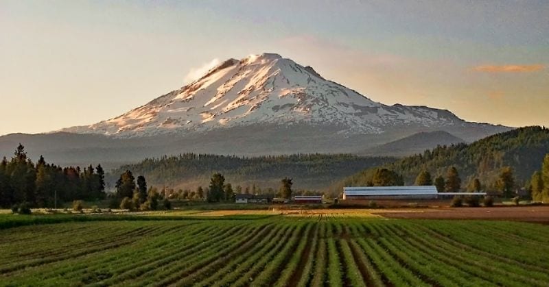
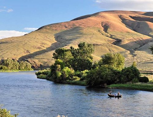
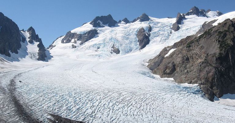
Changing channels: From Mt. Adams across the Cascades spring and summer snowmelt is critical to agriculture. It’s becoming less reliable. Photo by pfly/Creative Commons
By Nathan Gilles. December 3, 2020. For decades climate researchers have warned that as atmospheric temperatures continue to rise, the Pacific Northwest will have less snow and consequently less water to irrigate its crops. As if to hammer the point home, this year Oregon experienced yet another drought due in part to rising temperatures and melting snow.
In 2020, Oregon experienced some of its driest conditions on record. And yet, despite the overall lack of precipitation, the state’s mountains received more or less normal amounts of snow.
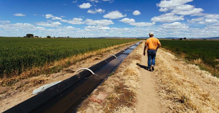
However, above-average spring temperatures melted mountain snow several weeks earlier than normal in several Oregon basins. This led to water flushing through local rivers and streams before it could be used for irrigation during the late spring and summer growing seasons. As temperatures continued to rise throughout the summer, water shortages and drought declarations followed.
Around the same time Oregon farmers were watching their water drain away, a May 2020 study published in the UK-based scientific journal Nature Climate Change literally put the Columbia River Basin on the world map as a watershed whose dependence on snow for irrigation places it on the losing side of climate change.
Here, too, the reason had to do with rising temperatures and melting snow, and here, too, the point was hammered home.
The study concluded that under future warming, the Columbia River Basin, the Pacific Northwest’s largest hydrologic basin, is likely to lose so much mountain snow that it will experience about the same degree of water scarcity as the Middle East basin containing the Tigris and Euphrates Rivers. In fact, the Columbia River Basin actually comes out looking a little worse off than the Tigris/Euphrates Basin, according to the study.
Less snow, more problems
Titled “Agricultural risks from changing snowmelt,” the study outlines two ways rising temperatures are expected to lead to water shortages in the future.
In the first condition, snow will accumulate more or less as normal, but melt early due to abnormally warm temperatures, as happened this year in some Oregon basins.
In the second condition, especially warm temperatures will cause precipitation to fall mostly as rain rather than as snow, as happened region-wide during the Northwest’s “snow drought” of 2015.
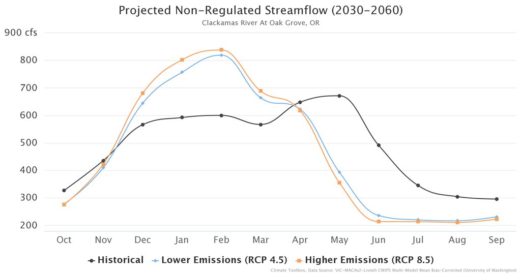
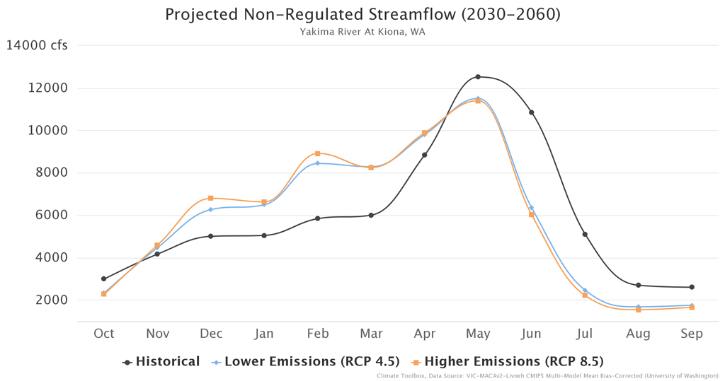
Forecasted and historical average streamflows in cubic feet per second for the Clackamas River as measured at Oak Grove, Oregon, and the Yakima River as measured at Kiona, Washington: Data is displayed for the water year, which runs from Oct. 1 of one calendar year to Sept. 30 of the following year. Flows are depicted as “unregulated,” meaning they don’t account for human manipulation of streamflow levels through reservoir management. Average historical streamflows (for the baseline 1971–2000) are shown in black. Average future streamflows are forecasted for the years 2030–2060. Two greenhouse gas emissions scenarios are shown: a high emissions scenario (RCP 8.5), which entails a higher degree of atmospheric warming; and a lower emissions scenario (RCP 4.5), which involves less warming. Streamflows under the high scenario are shown in orange; streamflows for the lower scenario are shown in blue. RCP stands for Representative Concentration Pathway, a measure of greenhouse gas concentration. Streamflows are higher in winter under projected warming scenarios due to the fact that less precipitation is falling as snow and more is falling as rain and immediately liberated to runoff. Source: The Climate Toolbox
Study co-author John Abatzoglou, a University of California Merced associate professor in Management of Complex Systems, says more rain and less snow is going to be the new normal as our regional climate warms.
“It’s pretty obvious that as we warm things up, we see a shift in the precipitation with more falling as rain and less as snow and that depletes our great bank account of snow that we rely on in our mountains,” says Abatzoglou.
Pacific Northwest compared with Middle East
Although Abatzoglou has written multiple studies about climate change and the Pacific Northwest, the Nature Climate Change study didn’t just look at the Northwest’s largest basin. Global in scale, the study examined how snow-dependent agriculture the world over is likely to fare as temperatures rise and snow and the water it provides for irrigation become scarce.
To do this, the study’s authors tackled the problem one hydrologic basin at a time. The researchers identified 45 basins that currently receive a significant proportion of their irrigated water from snowmelt, including the Columbia River Basin and Tigris/Euphrates Basin, as well as the Colorado River Basin and California’s San Joaquin Basin.
The study then employed a series of climate forecasts based on greenhouse gas emissions. One forecast scenario assumed just 2 degrees Celsius (3.6 degrees Fahrenheit) of warming above preindustrial levels by the end of this century (2070-2099). In this imagined scenario, humanity gets its act together, lowers its collective greenhouse emissions and global warming reaches a level deemed acceptable by the world community.
The other scenario assumes the opposite. In this scenario (depicted below), greenhouse gases are not reduced but continue to be emitted at their current rate. As a consequence, global temperatures rise by 4 degrees C (7.2 degrees F) by century’s end, well beyond acceptable levels and into potentially catastrophic territory.
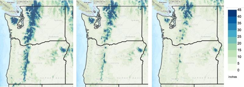
Forecasted average April 1 mountain snowpack: This comparison represents the high emissions/warming scenario measured in inches for early century (2010-2039, left), mid-century (2040-2069, center) and late century (2070-2099, right). Snowpack here is calculated as “snow water equivalent,” or the amount of liquid water contained in a given amount of snow. Source: The Climate Toolbox
As you’d expect, all basins experienced some degree of snowpack loss under both warming scenarios. But 4 degrees Celsius of warming proved far more detrimental than 2 degrees Celsius of warming.
Some basins saw greater loss of snowpack than others.
Climate researchers often refer to snowpack as a “natural reservoir,” as opposed to an artificial, human-made reservoir. Because warming temperatures mean losing that natural storage, after ranking each basin according to how dependent it currently is on snowpack and how vulnerable that snowpack is to future rising temperatures, the researchers then assessed how much additional water—either by building new artificial reservoirs or pumping more groundwater—each basin would need to make up for its lost natural (snow) reservoirs.
This is how the Pacific Northwest’s largest hydrologic basin got lumped in with the Middle East’s largest basin. Both basins are heavily reliant on snowmelt to irrigate their crops.
If global climate change is allowed to continue unchecked, both basins will see water shortages due to less snow. And that snowpack loss will be so large that both basins probably can’t build enough new storage and pump enough groundwater to make up the difference.
Snowmelt, irrigation out of sync
Of the initial 45 basins examined, the researchers identified 21 that are likely to see the largest impacts to their snowmelt-dependent agriculture. At the top of the list were Europe’s Po and Rhone-Ebro basins, as well as several basins in Central Asia. Just below these basins sat California’s San Joaquin Basin and the Colorado River Basin, with the Columbia and Tigris/Euphrates Basins positioned below them.
In the case of the Columbia River Basin, the study’s three-pronged approach—examining current dependence, projected snowpack losses and how much water each basin would need to make up for that lost snowpack—is revealing.
While the Columbia scored better than the San Joaquin and Colorado River Basins in terms of the amount of snowpack it’s expected to lose, the basin’s reliance on snowpack and its need to find new sources of water makes it far more vulnerable than it might at first appear.
Abatzoglou says it’s unlikely the basin can build enough new storage to make up for the natural storage snow provides. But, he stresses, storage is only part of the story. To fully understand the study’s conclusions, you need to look at timing.
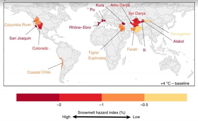
Snowmelt Hazard Index: This map from a study published in Nature Climate Change illustrates basins at risk from projected changes in snowmelt under a 4°C warming scenario. Snowmelt hazard index (SHI) is defined as the product of projected decreases in the share of irrigation demand met by snowmelt runoff, and expected increases in the share of demand met by alternative water sources. Risk further depends on the relative vulnerability of irrigated agriculture in basins exposed to snowmelt hazards. Courtesy of Nature Climate Change/Springer Nature
The climate of the Pacific Northwest and the Columbia River Basin can more or less be divided between the cool, wet months of late fall, winter, and early spring, when most crops aren’t being grown and watered; and the dry, warm months of late spring, summer and early fall, when most crops are being grown and watered.
For most of the 20th century and into the early years of this century, lack of precipitation during the growing season didn’t present a problem for farming because farmers could irrigate with water from snow that reliably melted during the growing season and reliably accumulated during the off season. But warming temperatures mean not only less snowpack, but also a change in the seasonal timing of that water, which adversely affects irrigation.
“Now we have this great system where snow melts in spring into early summer,” says Abatzoglou. “With the warming climate, we have run off that happens a month earlier and maybe a little bit more than that.”
An extreme example of this is California’s San Joaquin Basin. During the summer months, the basin’s farmers rely on surface water that comes almost entirely from snowmelt from the Sierras to irrigate their crops. Under a scenario of 2 degrees C of warming, the basin sees runoff from snowmelt occurring several weeks earlier than normal. Under 4 degrees C of warming, the runoff occurs as much as a month earlier.
If the timing of water demand remains stable, the San Joaquin’s water supply and water demand get out of sync.
“This leads to a much longer period in summer when you do not have surface water available to divert and use for irrigation,” says Abatzoglou. “That really does mess up that whole synchronicity between when the water is flowing and when you actually need it.”
However, says Jennifer Adam, a professor in the Department of Civil and Environmental Engineering at Washington State University who was not involved in the study, it’s a little more complicated than that.
“I appreciate the study getting us [the Columbia River Basin] back on the map where we belong as a vulnerable system,” says Adam of the Nature Climate Change study. “But it’s a global-scale study, and with a global-scale study you can’t quite get at the realism necessary to understand what’s going to happen in that [local] system.”
Altered growing seasons
Instead of the global focus of the Nature Climate Change study, Adam’s research focuses on the nitty-gritty details of how climate change is forecasted to affect the Columbia River Basin and its many sub-basins.
Consider the problem of storage. Across the entire Columbia River Basin, snowpack can hold less than half of the total volume that the basin’s artificial reservoirs can hold, according to an analysis performed for this story by Adam’s postdoctoral student Bo Xu.
However, for individual sub-basins, this relationship is often reversed. For example, the snowpack in Washington’s Yakima River Basin, whose farmers were especially hard hit due to low snowpack during the 2015 snow drought, holds more than twice as much water as nearby reservoirs.
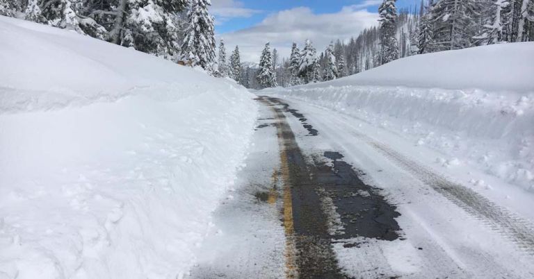
Cold comfort: Spring road crews may soon face fewer frozen obstacles. Photo by WSDOT
Adam says there are other factors to consider as well. As multiple studies have found, warming temperatures will very likely mean both an earlier start to the growing season as well as a longer growing season. A longer growing season, says Adam, also raises the possibility that farmers will “double crop,” or plant two sets of crops in succession, which could mean more demand for water.
Researchers also know that due to plant physiology, many crops are expected to be more efficient in their use of water as carbon dioxide levels rise.
In addition, Adam says research she’s involved in suggests that under future warming, the growing season in some sections of the Columbia River Basin might start before not after snowmelt is expected to flow into streams, rivers and irrigation canals. This means water demand will come earlier than water supply.
Then again, in still other sections of the basin, this might not happen at all. As Adam points out, the Columbia River Basin, particularly Washington, has lots of crops, such as apple trees and hops, that need water in the fall before they go dormant for the year.
“So, there’s all kinds of different things going on,” says Adam. “In some places irrigation demand doesn’t shift left [arrive earlier in the calendar year], but supply does and in other places irrigation demand shifts but supply doesn’t. There are two different factors and that’s what’s important to the story.”
The Nature Climate Change study acknowledges that both water demand and water supply are likely to shift in the future, though it doesn’t explore the implications of what this means. Adam says this makes the study not that useful for planning for the future.
However, she says she agrees with the study’s conclusion that the Columbia River Basin’s irrigated agriculture is vulnerable to climate change and that the basin needs to find new sources of water to make up for its disappearing snowpack.
Abatzoglou says he recognizes the study’s limitations, but says the takeaway for the Columbia River Basin and much of the American West is clear.
“Absent a massive change in water storage, building dams and reservoirs or finding a way to put more water into groundwater—and these are all technological engineering challenges that people are working on—we are going to have less water during the warm season for irrigation,” says Abatzoglou.
Nathan Gilles is a freelance science writer based in Vancouver, Washington. Gilles previously worked on the same federally funded climate science research grant as John Abatzoglou.

