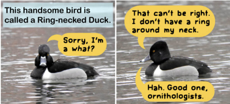
Stay Updated Subscribe today for the latest research + reporting about environmental news. Subscribe Now

Stay Updated Subscribe today for the latest research + reporting about environmental news.

Subscribe Now

Miko Ruhlen

Miko Ruhlen

About Miko Ruhlen

Miko Ruhlen, Associate Editor. Miko graduated from U.C. Berkeley and worked in California and the Columbia Gorge for well over a decade as an avian field biologist with non-profits, government agencies, and private consulting firms. She and her husband live in Hood River, Oregon. They own Hood River Hobbies and volunteer for local citizen science bird surveys and lead bird walks in their spare time.

Relocated Raptors in the Gorge

[media-credit name=”Photo by Max Peterson” align=”alignright” width=”450″][/media-credit]

Max Peterson spotted a Red-Tailed Hawk April 16 soaring above the Columbia River near Hood River’s popular water sport site: The Hook. He noticed unusual markings on the raptor’s wings and snapped a photo to get a closer look. 

Not plumage markings, he discovered, but wing tags.

I got involved because he contacted me about how and where to report it. Any time you see an animal or bird with tags it’s important to send scientists the information: when you saw it, where, and its condition (dead, alive, injured).

Researchers attach wing tags to track movement of birds through sightings like this. The orange patagial markers attached to wings of the raptor Max saw identified it as 4/M.

I discovered that a group called PDX Raptors trapped Red-tailed Hawk 4/M at the Portland airport in August 2016 – part of a wildlife management program sponsored by the Port of Portland PDX wildlife management. At-risk raptors like this are trapped and relocated (at least 40 miles away) in an effort to make the airfield safer for both birds and humans by reducing collisions with aircraft. In this case, PDX Raptors tagged and  transported it to Prineville, Oregon, where they released it. Since then, it had been sighted only one other time, also in Hood River in November 2016.

Published with permission of BirdandMoon.com

PDX Raptors uses information from sightings to determine the most successful release sites. Success equates to the number of birds not returning to the Portland airport. Approximately 75 percent of the Red-tailed Hawks never return.

Over 2,500 birds (primarily Red-tailed Hawks and American Kestrels) have been captured at the Portland airfield, banded and released since October 1999. Other species removed include Great-Blue Heron, Canada Goose, Snowy Owl, Great-horned Owl, Red-shouldered Hawk.

PDX Raptors uses a number techniques to deter wildlife: decreasing the number of prey (such as grasshoppers), covering drainage ponds, employing sound cannons, laser lights, and pyrotechnics. Some airports, like Vancouver, Canada, use trained falcons  to fly the airfield to scare off smaller birds.

Unfortunately, Red-Tailed Hawks at PDX airport have mostly habituated to the sound cannons and other deterrence contraptions. This species not only enjoys feeding on rodents in the grassy airfield and surrounding area, but sometimes nests on airport radio towers, other structures, and nearby trees.

Although bird strikes are rare, when they occur, wildlife and people can be severely injured. Potentially a strike could bring down a plane if it hits a critical location such as an engine. Intensive management efforts have lessened the number of bird-aircraft collisions at Portland (53 in 2009), but it is ongoing. Similar programs are implemented at other Pacific Northwest airports such as Seattle’s SeaTac.

Orange wing (patagial) tags are used because they are easier for the public to spot on live birds. The usual method of marking birds is by wrapping a band around one leg. But the leg bands are not usually reported or recovered unless the bird is found dead, injured, or recaptured.

If you see or find a red-tailed hawk with a patagial tag, report it to PDX Raptors on their website. The site features a map of tagged raptors sighted in Oregon, Washington and California. At least five other tagged red-tailed hawks seen in the Columbia River Gorge have been reported to PDX Raptors. If you see or find a bird with a leg band or a different type of tag, you can report it to the Bird Banding Lab at www.reportband.gov. Reporting sightings helps scientists and birds.

As our human population grows and land fills with structures and pavement – open space shrinks. Birds looking for an open field to forage have increasingly limited options. Interactions and conflicts between wildlife and humans will continue to increase and solutions often grow more complex with time.

Want to learn more about raptor identification? Visit Bonney Butte during raptor migration this fall. A local group of bird watchers, The Larks, hope to carpool up there this Sunday Sept 16 from Hood River if the smoke and the fire situation permit. Email miko(at)envirogorge.com to get in touch with this volunteer-led bird watching group. Or join the Bonney Butte Hawk Migration Festival September 22-23, 2017.

[media-credit name=”Photo by Max Peterson” align=”alignleft” width=”700″][/media-credit]


Wildfire and Wildlife

As Columbia Gorge wildfires burn and expand to over 30,000 acres just west of me and smoke fills my town, my first instinct is to check on my child with asthma. Next, I call and offer help to my friends, who live in a wooded area. They are packing their valuables to be ready to evacuate. At night, when everyone else is in bed, I start to worry about the forest creatures.

My mind conjures scenes from Bambi and Watership Down with creatures great and small fleeing forest destruction. I imagine the tiny pikas in their burrows, the ones that I visited this spring along the Historic Columbia River Highway. I remember their echoing yodels. I wonder if they attempt to run or burrow underground.

After a pause, I reign in my imagination and research the effects of fire on wildlife and come across a different mental image- caricatures of animals in formal attire at a party.

“Except under the most extreme conditions of fast-moving fronts, most appeared indifferent to the flames and, like human grazers at a 1950s cocktail party, many continued their foraging activities even in thick smoke,” wrote Mary Ann Franke in 2000 in her book Yellowstone in the Afterglow, Lessons from the Fires.

Although she noted that some animals fled the area, “some animals appeared curious, approaching a fire and watching trees burn; a black bear was seen sticking his paw into the flames of a burning log.” Franke compiled scientists’ research on impacts to wildlife after the Greater Yellowstone fire of 1988. “Although Yellowstone’s wildlife has adapted over thousands of years to fire, helicopters are still an alien presence,” Franke continues. “When a noisy chopper came near ferrying a water bucket or fire crew, elk visibly tensed and sometimes bolted.” It is ironic to think that sometimes an animal could be more frightened of that than a giant forest fire.

[/media-credit] Nesting cavity made by a woodpecker.

While extensive fires cause habitat alterations and displacement, they often don’t directly kill significant numbers of animals, Franke said. After the almost 800,000 acre fire in Yellowstone Park, extensive surveys by foot, horseback, and helicopter located 261 carcasses—246 elk, 9 bison, 4 mule deer, and 2 moose. Even assuming a large under count, the number of carcasses found is much less than the thousands that die during a typical winter.

They found that long-term effects of fire on organisms are complex: some population declined and others expanded. Although moose and snails were the only animals whose population decreased from the 1988 Yellowstone fire, only a few species were thoroughly studied long-term.

Echoing the Yellowstone findings, studies of the 2012 Pole Creek Fire within the Deschutes National Forest (near Sisters, OR) showed that habitat changes from fire influence wildlife more than direct injury and mortality. As you would expect, those with limited mobility are more vulnerable to the flames and smoke inhalation. Animals least affected lived in moist habitats.

Animals adapted to survive the fire regime that characterized their area  prior to humans arriving on the scene and changing the landscape. Fire severity in the Pole Creek Fire was within that area’s historic limits only at higher elevations.  Lower down a century of fire suppression practices resulted in the full destruction of the forest canopy where historically fires would have been less intensive due to more frequent fires.

[/media-credit] Black-backed woodpecker in the Gorge (Washington)

The Columbia Gorge Eagle Creek fire started in September after most bird species are done nesting and juveniles are able to fly away and migrate. Loss of larger, older trees impacts birds that need a closed canopy such as the Northern Spotted Owl, but recent studies show they use intensely burned areas for foraging. Other birds, such as white-headed woodpeckers and secondary cavity nesters such as bluebirds, may benefit from open habitat and dead snags for nesting. The black-backed woodpecker is a Gorge species that needs dead trees and prefers to move into an area after fires to feed on insects.

Big game wildlife, mule deer and elk may eventually benefit from regrowth of vegetation in the newly open areas. Vegetation loss raises stream temperature and results in erosion and degraded water quality for fish and aquatic species. Amphibians are vulnerable to changes increased temperatures and sediment in streams. Raptors may benefit from open habitat and charred ground cover by exposing prey hiding spots.

The list of winners and losers goes on, and effects of micro-habitats are complicated. But I feel more hopeful about the recovery of Gorge wildlife by taking the long view. Some wildlife will benefit from or adjust to changes; others will migrate to new areas. It is an ecological balancing act.

But, I still wonder about the pikas—those cute little rodents that live on talus slopes in the Gorge. During the 2011 Dollar Lake Fire on Mount Hood, fire reached several sites that had been surveyed prior to the fire for American Pika. “Within 2 years, [after the fire] pikas were widely distributed throughout burned areas and did not appear to be physiologically stressed at severely burned sites,” (Varner 2015).

[media-credit name=”Photo Credit USFWS” align=”alignleft” width=”450″][/media-credit]

Hoorah! Some survived the 2011 fire! Perhaps there is hope for the pikas I visited this spring. Different micro-climate conditions, fire intensity, and other factors may result in different levels of resilience of pikas in habitat encompassed by the Eagle Creek Fire. I have hope for the short term. But there are greater problems looming.

While some wildlife perish in wildfires every year, there are no documented cases of fires destroying entire populations or species. On the contrary, there are populations of animals wiped out due to habitat loss and fragmentation and more recently there is mention of severe climate change impacts to wildlife. An August 2017 study on the loss of pikas in Lake Tahoe, California is “among the first accounts of apparently climate-mediated, modern extirpation of a species from an interior portion of its geographic distribution, resulting in habitat fragmentation, and is the largest area yet reported for a modern-era pika extirpation”(Stewart, Wright and Heckman 2017).

But today the sun is finally out and I will breathe a bit of fresh air. Breathe deeply. I still worry for the firefighters on the front lines, the people displaced, the economic impacts to local business, and the birds and wildlife in my yard. I will put out water for the birds. Although the nesting season for birds was over, young juveniles are roaming around trying to figure out how to navigate and find food and shelter. I am concerned for them; I have a teen myself.

Although I do not want to minimize the impacts to our displaced Gorge wildlife due to this fire, one knot in the pit of my stomach has loosened a little bit. I have a little more hope for their long-term recovery and adaptability.

Biologists, volunteers, and citizen scientists will mobilize in the aftermath and record the recovery of native wildlife and plants from this inferno. The information gathered will help direct decisions about how to manage our forests and wildlife populations in the future. After we all recover our homes, lives, and livelihood,  scientists will need  volunteers to help them understand the impacts of this fire on the Gorge’s wildlife. As climate changes increases the frequency and intensity of fires, we must learn how to manage our forests and populations to be more resilient.

[/media-credit] A deer flees the fire, skirting behind Cascade Locks houses.


Subscribe

Get new stories in your inbox!

You can also find us on Facebook, Instagram, and Twitter.
Subscribe


Thank you to our business sponsors for making our work possible!

By |2018-11-30T13:39:26-08:0009/11/2017|Features, Old Articles, Wildfire, Wildlife|5 Comments

Why did the pasture-raised chicken cross the road?

[/media-credit] David and Michelina Roth won the Jola’s certificate!

In June, EnviroGorge created a food quiz to create awareness about environmental impacts of our food and HAVE FUN! Although we have awarded prizes to the winners (drawn at random from those who submitted their answers), you may still take it—-just for fun.  

Click here to take the quiz: Test Your Food IQ 

Thank you to our sponsors for donating prizes: Jola’s Food Cart, Gorge Grown, Stoked Roasters, Columbia Gorge Organic.

They were awarded to: Michelina and Dave Roth, White Salmon. Dan Richardson, The Dalles. Amy Lindley, White Salmon. Deanne Converse, Stevenson. Karen Harding, Mt. Hood. Linda Osborne,  Medford. Beth Flake, Hood River. Kyra Gorski, White Salmon.

Out of all the tough questions, the most often missed one was about which organizations certify farms that meet environmental practice standards. Most people incorrectly guessed that the Smithsonian Migratory Bird Center does not certify for environmental standards. Although they may be more well-known for research and conservation efforts, the Smithsonian Migratory Bird Center does in fact certify coffee farms. Beans with their bird-friendly certification must be organic and produced under high-quality shade requiring the use of native shade trees and combinations of foliage that provide habitat for migratory birds and native wildlife.

The correct answer to that question was Fair Trade Sustainability Alliance.  Although Fair Trade is a well-known and important certification, their goal is to improve farmers and workers quality of life through fair trade and sustainable community development. They do NOT certify on environmental sustainability.

Thanks to everyone for participating and reading EnviroGorge. We strive to create awareness about environmental issues that affect us all.

We had some laughs at the creative answers to our open-ended bonus question:

Why did the pasture-raised chicken cross the road?  We put some of our favorites in the graphic below for you to enjoy.

Why did the pasture-raised chicken cross the road? Reader responses.

By |2018-11-30T13:40:12-08:0008/24/2017|Agriculture, Energy, Features, Old Articles|0 Comments

Take Me to the River

One of the only small areas of beach with legal access under the train tracks. Covered with graffiti in recent years.

Story and photos by Miko Ruhlen. July 20, 2017. Recently, I realized that I take for granted public access to natural areas. Now National Monument protection designations are under review. Affordable housing competes with parks and open space. Park maintenance and enforcement funds are often unavailable. Some trails and native habitat restoration projects are only possible because of hard working volunteers.

And people. I run into more and more people on trails and beaches. That means more road and trail maintenance. Greater frequency of restroom and trash can maintenance. With the same amount of staff time. More dog poop. More litter. More vandalism.

I drove down to the old powerhouse on the Hood River last month. A favorite bird watching spot that I hadn’t visited in a couple years. Potholes in the road have increased in number and depth. The port-a-potty and garbage cans were gone.  Graffiti covered every sign. I came to commune with nature, but it felt like the entrance to an urban jungle.

Access to the Powerdale Corridor is complicated.

Kate Conley of Columbia Land Trust presents at a public meeting at the Hood River Library June 27

“If we don’t do anything, we will see a loss of public access over time,” said Kate Conley of Columbia Land Trust at a public meeting June 27, 2017 to present the Powerdale Recreation and Access Plan. With increased use of natural areas, and decaying infrastructure, owners and managers find it increasingly difficult to balance recreation, restoration, and responsibility in the Powerdale Corridor in Hood River.

The Powerdale Conservation Corridor is a narrow band of land bordering the lower Hood River from the former powerhouse and upstream about 3.5 miles including the former dam site. In March 2013, after removal of the Powerdale dam, approximately 400 acres of property was transferred from PacifiCorp to Columbia Land Trust (300 acres) and Hood River County (100 acres). While diverse habitat was gained by the Land Trust for conservation purposes, they also inherited complications with recreation use and access.

The Powerdale Lands Advisory Committee was formed to enhance communications between all stakeholders and interested parties. It includes representatives of Columbia Land Trust, Hood River County, Hood River Watershed Group, Oregon Deparment of Fish and Wildlife, Confederated Tribes of Warms Springs Reservation, Mount Hood Railroad, Hood River Valley Parks and Recreation District, Farmers Irrigation District, Powerdale Corridor neighbors, and the community. 

One of many large pot holes on Powerhouse road. It is a single lane with only a couple pullout spots. The author had to put the vehicle in reverse twice due to oncoming cars in the opposite direction.

Problems? What problems? Locals have been going there for years.

Currently, there is only one legal access road for the public to access the Powerdale Corridor without trespassing through private property. This road to  the powerhouse is on land now owned by Hood River County, buy they do not maintain the road, nor do they have plans to do so. Due to large potholes, crumbling pavement, and potential wash outs or collapse, the single lane dirt road could soon become impassable, without ongoing maintenance. It is not possible to widen the road due to the steep drop off into the river. It has washed out in the recent past.

Alternative public access roads or trails leading to other parts of the corridor either involve: 1. gaining easements from property owners or 2. steep cliffs which make building near-impossible.

The portable toilet and garbage cans were removed from the powerhouse parking area due to vandalism and difficulty maintaining them.

Hikers trespassing on the railroad tracks.

Currently, to get access to the corridor, people frequently walk along the railroad tracks.  The Mount Hood Railroad owns the tracks and a 60-foot wide corridor surrounding them. Signs clearly state that walking on or near the tracks is not allowed and considered trespassing. Because there is no alternate route available, people risk collision with a train (albeit slow-moving) by crossing the river via the train trestle.

Ron Kaufman, General Manager of the Mount Hood Railroad voiced concerns at the June 27 meeting about safety of people crossing the trestle as well as erosion of the track bed from walking on it. “You can’t continue to have more and more people without more responsibility,” he said, “but one thing I keep coming back to is that the river is a treasure and I hate to see a position where people are cut off from it.”

Recreation use of the area has notably increased during the past couple years, Conley told the audience, “We really feel like the current level of use calls for more management. We need to step it up and do a bit more – clean up the trash, prevent trespassing.” Key recommendations of the Recreation and Access Plan to maintain public access include maintaining Powerhouse Road, creating a legal railroad crossing and trail easement, development of bridges for public access to beaches, and obtaining easements to enable public access to privately-owned sections of road such as Copper Dam Road. All of which come with seemingly insurmountable problems: cost, cliffs, conflicts with landowners, carrying capacity.

Painted over sign explaining that walking the tracks to cross the river is trespassing.

Not everyone supports increased access to the Powerdale Corridor. A property owner along the corridor complained during the meeting that people were trespassing on her private road which is expensive to maintain. And she added that people frequently swim nude at the swimming hole, despite presence of nearby children.

Illegal camping, potentially sparking wildfires, is a concern. Homeless encampments have been observed. Due to legal issues and lack of resources, problems are difficult to control. If visitor use escalates creating problems for the railroad, Conley said they railroad could restrict access by erecting fences. One of the reasons for creating an access plan is to troubleshoot solutions for all stakeholders and recreational users.

What about native plants and wildlife?

Although this area is slated for low-impact recreation, increased human presence could potentially impact native wildlife due to disturbance, displacement, pollution, and illegal hunting. Remote cameras have captured photos of a variety of mammals using the area including bear, bobcat, coyote, and elk. Harlequin duck, mergansers, dippers, and mallards swim along the river with their ducklings. The riparian area is filled with songs of nesting warblers, sparrows, grosbeaks, and woodpeckers every spring. Salmon, steelhead, bull trout, and lamprey swim upstream freely from the Columbia since the Powerdale Dam was removed in 2010. Restoration work along the Hood River and its tributaries so far includes: invasive plant removal, planting of over 1400 native trees and shrubs, and creating log jam structures to restore the floodplain and provide refuge habitat for juvenile fish.

Mallard ducklings below the Powerhouse.

At the meeting, Columbia Land Trust’s Conley made it clear that protecting existing fish and wildlife habitat in the area is the number one goal of the land trust. Other goals include: providing safe legal public access for recreation, education, and preserving tribal fishing rights. All these other goals must complement their Goal #1 to protect terrestrial and aquatic ecosystems within the corridor.

Currently they are tackling each problem as it arises – putting out fires. Conley explained, “The land trust advocates for a more proactive approach.”

“Personally, I want to enjoy nature close to home,” Conley said, “This is a special place. It is important that people who live here have access to the [Hood] river.”

For further information, read The Powerdale Recreation and Access Plan. To comment on the plan, contact Kate Conley of Columbia Land Trust plan or Mikel Diwan at Hood River County Public Works.

Subscribe

Get new stories in your inbox!

You can also find us on Facebook, Instagram, and Twitter.
Subscribe

© Copyright 2013-2025 Columbia Insight. All Rights Reserved.

As a 501(c)3 nonprofit organization, all donations to Columbia Insight are tax deductible to the full extent of the law. Our nonprofit federal tax-exempt number is 82-4504894.