Stay Updated Subscribe today for the latest research + reporting about environmental news. Subscribe Now

Stay Updated Subscribe today for the latest research + reporting about environmental news.

Subscribe Now

Kendra Chamberlin

Kendra Chamberlin

Kendra Chamberlain

About Kendra Chamberlain

Columbia Insight contributing editor Kendra Chamberlain is a freelance journalist based in Eugene, Oregon, covering environment, energy and climate change. Her work has appeared in DeSmog Blog, High Country News, InvestigateWest and Ensia.

BPA ready to join new Southwest energy market

Critics denounce a BPA draft decision to leave the Western energy market, possibly threatening renewables growth at home

Transmission lines in field

Market shift: The Bonneville Power Administration is turning its back on California and sending itd power elsewhere. Image: BPA

By Kendra Chamberlain. March 13, 2025. The Bonneville Power Administration (BPA) announced last week that it intends to join a new electricity trading market rather than participate in a similar market being developed by California’s electricity market CAISO.

The news has resulted in cheers from public utilities and outcry from consumer advocates.

It also raises concerns about the continued growth of renewable energy sources in the Columbia River Basin.

Utilities across the West are considering how to move toward day-ahead markets, which operate in conjunction with real-time markets and allow utilities to lock in electricity prices in advance.

CAISO began developing its Extended Day Ahead Market (EDAM) in 2019. In 2022, the Arkansas-based Southwest Power Pool (SPP) began work on its own day-ahead market, called Markets+. SPP operates grids in all or parts of Arkansas, Iowa, Kansas, Louisiana, Minnesota, Missouri, Montana, Nebraska, New Mexico, North Dakota, Oklahoma, South Dakota, Texas and Wyoming.

UPDATE: On March 18, 2025, the BPA adds: “While based in Arkansas, SPP is standing up a newly designed market specifically for the western part of the U.S. This western market is not intended to transact with SPP’s already existing and operating eastern markets.”

The BPA says it has evaluated opportunities to join a day-ahead market, and then looked at which market would be the most advantageous to join.

In its draft decision, BPA—which participated in the development of both day-ahead markets—emphasized that the SPP’s Markets+ would offer an independent governance mode that BPA staff believes will help it realize more long-term benefits than CAISO’s EDAM.

“Bonneville concluded that joining a day-ahead market is in the best interest of the agency and its customers from an economic perspective,” wrote in its Day-Ahead Market Draft Policy paper.

Many of the utilities served by BPA are on board with the decision.

“BPA’s decision to move forward with Markets+ underscores the strength of the SPP Markets+ option which was designed by diverse stakeholders across the West,” Scott Simms, CEO and executive director of the Public Power Council (PPC), said in a statement. The Public Power Council is an industry group representing consumer-owned utilities in the Pacific Northwest that purchase power from BPA.

The BPA will still be legally obligated to supply power to the 140 consumer-owned utilities in the region first, and will continue to sell its excess power to other utilities in the Pacific Northwest.

Environmental implications

Some of the larger power companies in the region, like PacifiCorp and PGE, have said they’ll stick with CAISO’s EDAM for now. Other companies may follow BPA’s lead and move to Markets+.

The Northwest Energy Coalition (NWEC), a group of 100 environmental and civic organizations, utilities and businesses across the Pacific Northwest, says that many studies—including one commissioned by BPA itself—show the decision will lead to increased costs, less reliability and more difficulty in adding renewable energy sources to the grid.

NWEC senior policy associate Fred Heutte told Columbia Insight that the decision to join SPP’s day-ahead market is confusing.

The move would result in two markets operating atop the same grid in the Pacific Northwest, and would reduce diversity of power sources in each market.

There’s also limited transmission between the Northwest and SPP’s other participating grids.

U.S. electric power markets map

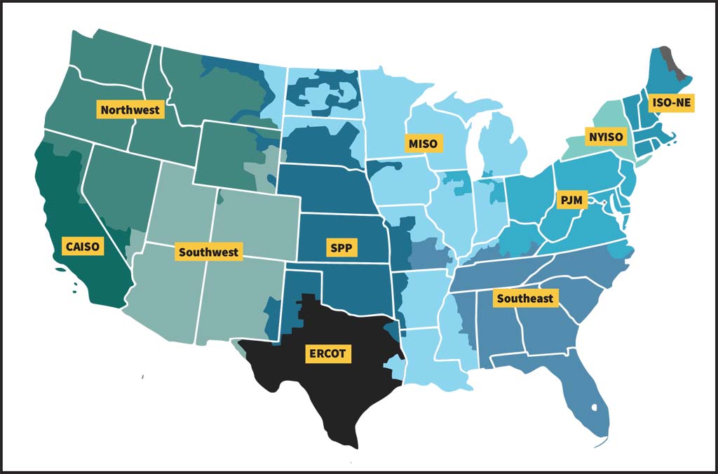
U.S. electric power markets: Traditional wholesale electricity markets exist primarily in the Southeast, Southwest and Northwest. Federal systems include the Tennessee Valley Authority, Western Area Power Administration and the Portland-based Bonneville Power Administration. Map: FERC

The emergence of two markets in the region could have big implications for renewable energy integration in the Pacific Northwest.

It could complicate coordinating renewable energy development and new transmission projects within the region, said Heutte, and will create “seams” between the two markets that will generate new costs related to managing power flows and coordinating transmission at the boundaries of two organized markets.

It could also impact efforts to remove the Lower Snake River dams in support of salmon recovery in the river.

A major settlement agreement 22 years in the making and released in 2024, calls for up to $1 billion in investments along the Lower Snake River over the next decade for salmon recovery and renewable energy build-outs to facilitate the removal of four dams along the river. The agreement is between the Confederated Tribes and Bands of the Yakama Nation, Confederated Tribes of the Umatilla Indian Reservation, Confederated Tribes of the Warm Springs Reservation of Oregon and the Nez Perce Tribe, along with the states of Oregon and Washington and several nonprofits.

The proposal to remove the four dams hinges on replacing the power those dams generate with renewables.

“A single market would make it easier to develop and transmit replacement renewable energy—much of which can be developed in the area around those dams and use existing transmission,” said Heutte.

The four dams on the Lower Snake River are “run of the river” dams, meaning they don’t offer much storage of water and so can generate power based only on what’s coming down the river.

The dams produce the most power during the spring run-off season—at a time when hydropower in the region is at a surplus—and produce much less power during other parts of the year.

“A balanced, clean-energy replacement portfolio for the Lower Snake River dams will have a better fit to seasonal power demand in the Northwest, especially in mid-winter and late summer when flows in the Snake River are low,” said Heutte.

Who will pay more?

Not everyone is convinced the move will benefit consumers.

“Every power customer in the Northwest is at risk for higher costs on their monthly bills,” NWEC said in a statement.

“Bonneville’s own commissioned study by E3 shows that the likely outcome of being in Markets+ would be plus or minus around $100 million a year of net losses compared to where they are now in the Western Energy and Imbalance Market,” said Heutte. “Just on the cost side, this doesn’t make much sense at all. Why would an agency do this, even though their own study says it’ll [lose money]?”

BPA has admitted its analyses show joining EDAM would offer financial benefits to BPA and its customers.

But BPA’s Rachel Dibble told reporters during a press briefing that it sees SPP’s governance model of the day-ahead market as a key benefit.

“We have really significant beliefs about the importance of governance, the importance of an open stakeholder process, and while those cannot be quantified, those are qualitative elements that we hold as very high priorities, and we do believe in the long run, they will result in positive quantitative benefits,” Dibble said, according to Utility Dive.

BPA has long been critical of CAISO’s decision-making. The system is governed by a board appointed by the Governor of California, and is beholden to California’s state laws, and its ratepayers, a fact that BPA staff believes have left BPA in a less than ideal position as a participant.

BPA said in its draft decision that it still felt it was playing second fiddle to California interests during the development of EDAM.

NWEC’s Heutte isn’t buying that argument.

There’s already an initiative underway to address CAISO’s governance, he said. The Pathway Initiative, which aims to increase transparency and include more stakeholders in governance decisions “sets up a new governance structure that’s better than what anybody has right now,” Heutte said.

“Let’s get real here. What is motivating this? This is the big question. Why?” Heutte said. “We don’t really know.”

By |2026-01-09T13:51:09-08:0003/13/2025|Energy, News|0 Comments

Group alleges Port of Morrow misled governor for permission to dump toxic water

The Port successfully petitioned the state for an executive order to suspend environmental regulations in order to save jobs

Port of Morrow aerial

It’s really beneath them: Established in 1958, Port of Morrow is one of Oregon’s most largest industrial centers and chronic polluters. Photo: Port of Morrow

By Kendra Chamberlain. February 27, 2025. A group of 26 conservation nonprofits, grassroots organizations and community leaders have signed a letter sent to Ore. Gov. Tina Kotek alleging the Port of Morrow, located along the Columbia River in northeastern Oregon, intentionally misled the governor about its wastewater storage capacity while seeking an emergency order earlier this year.

The Feb. 21 letter, authored by advocacy group Oregon Rural Action and undersigned by a former Oregon Department of Environmental Quality (DEQ) administrator and a former Morrow County commissioner, among others, requests that the governor rescind an executive order she made in January that allows the Port of Morrow to violate its wastewater permit.

“We believe this decision was misguided and may have been based on incomplete, misleading, or inaccurate information,” the letter reads. “[The executive order] needlessly allows for increased pollution during the high-risk winter season when the risk to the public is highest, threatening to worsen an already severe crisis.”

The letter also requests the governor declare a public health and environmental emergency in the Lower Umatilla Basin due to nitrate pollution in groundwater within the Lower Umatilla Basin Groundwater Management Area.

A spokesperson for the Office of Governor Kotek told Columbia Insight in an email that her office had received the letter and is reviewing it.

The Lower Umatilla Basin Groundwater Management Area, which spans 550 square miles across Morrow and Umatilla counties along the Columbia River, has been plagued with high levels of nitrates in groundwater since the 1990s.

A report released by Oregon DEQ in January found that nitrate contamination, driven primarily by agricultural practices, has continued to worsen over the past decade.

“The people who are affected by this pollution, the victims of pollution, are low-income, non-English speaking, disproportionately Latino and immigrants, working class,” Kaleb Lay, director of policy and research at Oregon Rural Action, told Columbia Insight. “They don’t have a lot of power on their own, but that’s why we’re supposed to have regulations and laws—so the polluters can’t get away with this sort of thing.”

UPDATE, Feb. 27. 2025: Since the publication of this story, Gov. Kotek responded by letter to the Feb. 21 letter from Oregon Rural Action. Gov. Kotek’s largely pro forma response did not address concerns about the Port of Morrow’s “incomplete, misleading, or inaccurate information.” Gov. Kotek’s letter, in part, reads:

“In the last several years, the Port of Morrow has worked more closely and intentionally with the Oregon Department of Environmental Quality (DEQ), sticking to a permit compliance schedule that is a critical part of the long-term strategy to reduce nitrate contamination in the region. Industries at the Port of Morrow took voluntary measures to reduce wastewater in the basin headed into this non-growing season, and this will be the last winter when land application will occur due to the upgrades that the Port of Morrow is currently making and the updated schedule that DEQ has required.”

The letter goes on to say:

“Remediating the groundwater contamination in the basin will take decades. … I want residents who have been impacted by this water contamination to know that the state and our partners have been working with urgency to deliver solutions. Free testing and retesting, treatment options, and water delivery will continue to be provided by the State of Oregon to all residents in the LUBGWMA whose water tests higher than 10mg/L of nitrate—at no cost to residents.”

Chronic polluter

The Port of Morrow, Oregon’s largest industrial port east of Portland, accepts wastewater from industrial businesses such as food processing plants, data centers and a PG&E-owned power plant.

The Port then moves that nitrogen-rich wastewater upgradient for land application on agricultural fields.

Specific conditions must be met for the land application of wastewater. The Port is only allowed to dump a certain amount of wastewater at a time to agricultural land in order to ensure the nitrates don’t reach groundwater stores.

Lower Umatilla Basin Groundwater Management Area map

Map: State of Oregon

Land application during the rainy season is especially tricky, because if the soil is already saturated with water (from, say, a run of rainy weather), the Port must wait until the soil dries before spreading wastewater.

The wastewater is stored in lagoons until it can be disposed of.

“The fundamental problem is the Port has chronically—for years, years and years—produced way more [wastewater] than the fields where they’re allowed to dispose of it can possibly handle, which creates this leaching problem, which leads to permit violations and contaminates the groundwater,” said Lay.

A 2022 investigation by the Oregon Capital Chronicle found the Port had violated its wastewater permits for the previous 15 years. In the last two years, DEQ has fined the Port more than $3.1 million for permit violations.

The Port is in the midst of building out more lagoons to store the wastewater, a move that it hopes will end future winter water dumps on the land. Those lagoons are expected to be completed by November 2025.

Executive order suspends rules

Amid a spell of unusually wet weather in December 2024, the Port of Morrow requested the governor sign an emergency order that would allow it to violate wastewater regulations, arguing that the predicted precipitation and freezing conditions would overwhelm its wastewater storage capacity, thus forcing the Port to exceed its land-application capacity.

Without the order, the Port argued, it wouldn’t have any choice but to stop accepting wastewater, because it wouldn’t have any place to legally put it. That decision might have forced the industrial facilities generating wastewater to cease operations, which in turn could have led to “furloughs of potentially thousands of workers resulting in substantial economic harm to the region and the State of Oregon,” according to Gov. Kotek’s subsequent executive order (EO), issued Jan. 13.

“Allowing them to violate without holding them accountable is just giving them a free pass to pollute.” —Kaleb Lay

The EO granted the Port of Morrow’s request and declared a state of emergency “due to risk of economic shutdown” in Morrow and Umatilla counties.

The EO allows the Port to apply wastewater only to fields that are down-gradient from domestic wells or those that are designated as low-risk for contamination.

“I did not make this decision lightly,” Kotek said in a news release. “We must balance protecting thousands of jobs in the region, the national food supply, and domestic well users during this short period of time during an unusually wet winter.”

Kotek’s order allows an exception to the Port of Morrow’s wastewater permit only from Jan. 15 through Feb. 28.

The Port of Morrow officially invoked the EO’s use on Feb. 17, nearly a month after the EO was issued.

Port of Morrow Executive Director Lisa Mittelsdorf told Columbia Insight in an emailed statement that the Port was able to delay invoking the order thanks to conservation efforts and management of its storage-lagoon capacity.

“The order was invoked in accordance with its terms only when the Port determined that available storage capacity would be exhausted within seven days. As required by the order, the Port restricted land application to two farms with no down-gradient domestic users of alluvial groundwater,” the statement reads.

Worrying precedent

Oregon Rural Action, however, doesn’t think the Port of Morrow was being honest in its emergency order request.

In its letter to Gov. Kotek, the group compared statements and arguments used in the emergency request against the Port of Morrow’s own monthly reports to DEQ.

“It’s a paper-thin argument that falls apart right away,” said Lay.

Kaleb Lay, director of policy and research for Oregon Rural Action

Kaleb Lay. Photo: Keith Schneider/Circle of Blue

He said the Port’s DEQ report states its storage capacity was only at 44% at the end of December, with roughly 335 million gallons of capacity available, despite the Port’s claim to the governor’s office that it was running out of storage space.

“At the same time, they were expecting to produce less wastewater than they had in the previous two months,” said Lay. “So for the remainder of the winter [including January and February] they had more than half their wastewater storage available to them, and were expecting to make less [wastewater in January and February], which would lead one to believe that they could store all of what was left without much trouble at all.

“It just doesn’t seem like that due diligence was done in the making of this decision to grant them this power.”

The EO is set to expire at the end of this week, but “every day counts,” according to Lay.

And concerns persist over the setting of a controversial precedent based on faulty information.

“The permit conditions exist for a reason. They’re not perfect, but every violation that [occurs] is a violation because [the permit] is trying to prevent contamination of groundwater. Allowing them to violate without holding them accountable is just giving them a free pass to pollute,” said Lay.

By |2026-01-09T13:54:25-08:0002/27/2025|Water|2 Comments

Remember that big SDS Timber land sale? Here’s what’s happening with that forest

A partnership of conservation groups and private landowners is keeping logging in, but commercial development out

Forest, logging, southwest Washington

Green investing: Huge parcels of forestland in southwest Washington were liquidated in 2021. Now, new plans for the land are coming into view. Photo: Columbia Land Trust

By Kendra Chamberlain. February 19, 2025. Back in 2021, the SDS Lumber and Timber Company’s sale of its extensive mill properties and nearly 100,000 acres of Pacific Northwest forest reserves to sent a shockwave through the Columbia River Gorge as well as the global timber industry.

Now, through a complex partnership agreement, nearly all of the forests formerly owned by SDS in southwestern Washington are remaining open to logging, while being protected against future commercial or residential development.

The Columbia Land Trust has announced a $36 million award from the U.S. Forest Service that will go toward establishing a new conservation easement on a 29,000-acre piece of former SDS Lumber land. (The award, which will flow through Washington’s Department of Natural Resources, came in mid-December and has not been impacted by recent freezes on federal grants, according to the Columbia Land Trust.)

The land is located in Washington’s White Salmon and Klickitat River watersheds.

The award is part of the Forest Service’s Forest Legacy program, which seeks to conserve timberland as open spaces and working forests, while maintaining wildlife habitat and clean drinking water.

Keeping timberlands as “working forests,” rather than carving up the land into commercial or residential parcels, is considered a major conservation win, according to Columbia Land Trust Executive Director Meg Rutledge.

“Working forests” is a malleable term that broadly refers to forestland that’s commercially logged, while sometimes also being managed to preserve certain areas for wildlife habitat and recreation.

“This entire region is under significant pressure of land conversion,” Rutledge told Columbia Insight. “There’s so much growth, and it’s not always strategic, when these large forestry blocks go up for sale, they can end up getting really fragmented.”

Mt. Adams Forest Conservation phases map

Phase Three of the management plan for former SDS Timber land more than doubles the size of protected area. Map: Columbia Land Trust

The deal is the third phase of a conservation strategy developed by the Columbia Land Trust, along with the landowner Twin Creeks Timber/Green Diamond Resource Company, The Conservation Fund and Washington’s Department of Natural Resources.

All told, the group has established conservation easements to cover 48,000 acres of timberland between the Columbia River and Mt. Adams. The easements contain restrictions on development aside from logging.

All of that land will be managed as working forest, but will offer public and recreational access, which Rutledge said was an important piece of the easement deals.

“Part of our motivation for this project was to conserve the land itself, as well as the values of how that land was being used,” said Rutledge. “So that does mean it will remain a working forest, which means they are part of both the rural economy as well as the forestry system economy.

“And it will continue to provide recreational access. That was a clear goal of this partnership, that these easements would ensure that recreational access was continued in these forests.”

Striving for balance

In 2021, Columbia Insight reported extensively on the sale of land owned by Bingen, Wash.-based SDS Lumber. The company’s 96,000-plus acres of commercial forest had been managed for decades under a 60-year harvest rotation, meaning the trees planted were allowed to grow for much longer than most other logging forests in Washington before being cut down.

At the time, The Conservation Fund stepped in to acquire 35,000 acres of the SDS timberlands, representing about a third of the land up for sale and including important oak habitat, river frontage and municipal drinking water sources.

That deal also included logging on the land, with prioritizations for protecting water quality and wildlife habitat.

Woodland path in southwest Washington

Development curtailed: Houses out, hikers in. Photo: Columbia Land Trust

Twin Creeks Timber, owned by Green Diamond Resource Company, acquired 61,000 acres of land that it promised to manage as timberlands. Now, roughly 48,000 acres of that land, representing 79% of what Green Diamond acquired from SDS Lumber, is under various conservation easement agreements with Washington DNR.

That means that of the 96,000 acres of SDS Lumber land, some 83,000 acres are working forests under some form of protection from other development.

Jason Callahan, policy and communications manager at Green Diamond, told Columbia Insight that the forests will still be logged at rates “consistent with our management objectives for the land.”

“There are no limitations to what we do to manage our forest [under the easement],” Callahan told Columbia Insight. “But the conservation value is that intact forest has more conservation value than twenty-, thirty-, forty-acre ranchettes that are torn up and chopped up into little development spots.”

Callahan added that the company is certified under the Sustainable Forestry Initiative in the Columbia River Gorge.

“Green Diamond is committed to being a sustainable forest company, and we show that by that third party certification,” he said. “There’s a lot of work and money to do it, but, but it’s in line with the company values.”

Logging forests isn’t typically considered “conservation,” but groups like The Conservation Fund and Columbia Land Trust seem confident that a big tract of working forest is better for wildlife and watershed health than what other development might look like.

“This is an unusual partnership for several large conservation NGOs like The Conservation Fund and Columbia Land Trust to partner with industry groups, including Green Diamond, as well as investors,” said Rutledge. “I also think it’s what it takes to achieve conservation on such a large scale. It’s complicated, it’s ambitious, it’s rare.”

By |2026-01-09T13:56:49-08:0002/19/2025|Conservation|4 Comments

Major agreement reached over nuclear waste

Wash. Dept. of Ecology says deal outlines an “achievable course for cleaning up millions of gallons of radioactive waste” at Hanford

hanford Site

Big mess: The Hanford Site covers 568 square miles in Washington around the Columbia River. Photo: U.S. Department of Energy

By Kendra Chamberlain. February 6, 2025. The ink has dried on the latest agreement in the saga of cleanup efforts at the Hanford Site in southeastern Washington, this one 34 years in the making.

In what the Washington State Department of Ecology is calling a “landmark” and “holistic agreement” reached between the state agency, the U.S. Department of Energy (DOE) and the U.S. Environmental Protection Agency a pathway has been established for continuing tank waste retrieval and treatment at Hanford through 2040.

The agreement includes a finalized settlement and makes adjustments to the existing federal consent decree and the original Tri-Party Agreement made in 1989 between DOE, EPA and the State of Washington.

The negotiation process has not been without detractors.

The Yakama Nation, Confederated Tribes of the Umatilla Indian Reservation and Nez Perce Tribe—Tribes with ties and treaty rights to the land that the Hanford site was built upon—have said they were left out of the negotiations that led to the latest agreement, as well as the original 1989 Tri-Party Agreement.

In 2023, tribal scientists and experts corrected DOE modeling that would have led to more contamination, according to a report from the Associated Press.

Environmental and watchdog groups are concerned about how cleanup at Hanford will continue.

“It’s not negotiable that Hanford cleanup should go forward in a way that protects the people of the region. It’s just too important,” Dan Serres, advocacy director at Columbia Riverkeeper, told Columbia Insight. “This settlement underscores the importance of that work. The details of it are clearly uncertain.

“There are big questions about whether some of this very toxic and radioactive material can be managed safely and disposed of safely in the ways suggested by this agreement.

Massive task

Hanford was established in 1943 as part of the Manhattan Project and produced more than 60% of the nation’s plutonium between 1944 and 1987. It generated millions of gallons of nuclear waste that’s been stored in underground tanks ever since.

The volume of underground waste at the site is mind-boggling. It includes 177 underground waste storage tanks. Each tank contains between 55,000 and 1.2 million gallons of waste. Many of those tanks have leaked contaminants over the decades.

All together, the tanks contain 56 million gallons of nuclear waste that need to be retrieved, treated and stored properly to prevent further soil and groundwater contamination.

Hanford nuclear waste tanks-WWII

Leaking legacy: Hanford’s B Tank Farm was constructed during WWII. The tanks were covered with soil to contain radioactivity. In 2021, the Department of Energy announced one of the tanks was leaking toxic, radioactive nuclear waste into the soil. In 2024, Energy announced at least three tanks at Hanford were likely leaking. Photo: DOE archives

Cleanup efforts have been ongoing at the site since 1989. The scale of the task is astounding. The mission employs 12,000 people, ranging from state and federal employees to contractors and vendors.

Cleanup of the entire site is expected to reach into the 2070s or 2080s, nearly a century after the nuclear work concluded.

Dealing with the underground waste and its contamination is “arguably one of the hardest, if not the hardest, piece of the Hanford cleanup mission,” according to Stephanie Schleif, Ecology’s nuclear waste program manager. The state department is the lead regulator overseeing the tank waste retrieval and remediation portion of the process.

The federal Department of Energy says it’s made progress: 33.8 billion gallons of groundwater have been treated, over a thousand waste sites have been remediated and 220,000 gallons of tank waste is ready for treatment.

Shipping waste out of state

The original Tri-Party Agreement includes a process by which the waste is divided into two classes: high-level waste, which contains the most radioactive material, and low-activity waste, which makes up 90% of the waste that needs to be dealt with.

Under the new agreement, the DOE won’t apply its newer, controversial interpretation of “high-level waste” to the waste at Hanford. But it will allow some of the high-level waste to be re-classified and therefore be eligible for alternative—and cheaper —treatment methods. That’s in line with a September 2024 GOA report that recommended some of the waste be reclassified to save money and speed up the process.

Under the new agreement, some low-activity waste may now be treated by mixing it with a concrete-like material to solidify the waste (called grouting).

The grouted waste cannot stay on site, however. It will be transported to a commercial disposal site.

Where the grouting process will occur, and where that waste will go, remains undetermined. There are currently two commercial disposal facilities for grouted waste in the United States: one in Texas and one in Utah.

The DOE is currently running a pilot program, called the Test Bed Initiative, which will use alternative methods like grouting to treat 2,000 gallons of low-activity waste from Hanford.

That waste will be stored at a dump site in Andrews County, Texas.

Washington’s Department of Ecology doesn’t believe grouting nuclear waste is a safe option if the waste were to stay at Hanford, according to Ryan Miller, Ecology’s nuclear waste program communications manager.

“Ecology believes grouted low-activity tank waste is not suitable for permanent disposal at the Hanford Site,” Miller told Columbia Insight in an email. “The U.S. Department of Energy’s 2012 Tank Closure and Waste Management Environmental Impact Statement shows there would be an unacceptable impact to groundwater at Hanford if grouted low-activity tank waste is disposed of onsite.

“However, Ecology is supportive of disposal of grouted low-activity tank waste at offsite facilities that have more robust geology and that don’t have the groundwater contamination concerns we have here at Hanford.”

The rest of the low-activity waste and the high-level waste will undergo vitrification—a process in which the waste is solidified into a glass-like substance. Vitrified low-activity waste will remain at Hanford.

The high-level waste will stay at Hanford for the foreseeable future, too.

“Vitrified high-level waste will need to be disposed of off-site, at a deep geologic repository,” wrote Miller. “Such a repository currently does not exist. Until that repository is identified, vitrified high-level waste will be interim-stored at the Hanford Site.”

The federal government has been struggling to build such a repository for the last three decades.

By |2026-01-09T14:32:37-08:0002/06/2025|Waste Management|1 Comment

Enviros, feds agree to protect a huge chunk of wild habitat

Pronghorns and sage-grouse rejoice as the Bureau of Land Management moves to preserve a swath of sagebrush steppe in Oregon

Sunlight highlights Sheldon National Wildlife Refuge, Nevada

Open, wide: The 57,304-acre Sheldon National Wildlife Refuge on the Nevada-Oregon border is just one protected place where the deer and the antelope play. Photo: Wikimedia Commons

By Kendra Chamberlain. January 29, 2025. A huge chunk of some of the best sagebrush habitat in the Pacific Northwest for sage-grouse and pronghorn (aka pronghorn antelope) has just received a significant safeguard.

The Bureau of Land Management is expanding protections across 1.1 million acres of land in the Greater Hart-Sheldon area in southeastern Oregon.

The Greater Hart-Sheldon refers to a swath of land between and surrounding two important refuges: the Hart National Antelope Refuge in Oregon and the Sheldon National Wildlife Refuge Area in northern Nevada, a small piece of which is located in Oregon. Much of that land falls within the BLM’s Lakeview District.

Oregon's Lakeview District BLM management area

Map: BLM

On Jan. 17, the federal agency concluded a decades-long process to amend the 2003 Lakeview Resource Management Plan (RMP), re-designating parcels of land across the district to afford more protections for wildlife and habitat.

“As an update process, it’s been 20 years in the making,” says Ryan Houston, executive director of the Oregon Natural Desert Association (ONDA), a Bend-based conservation group that for decades has worked for more protections in the area.

Resource Management Plan updates typically come only once every couple of decades, and are often slow-moving, arduous processes.

ONDA considered this RMP update a “once in a generation opportunity” to address protecting sections of habitat that are currently vulnerable to things like mining and energy siting.

The update is part of a 2010 legal settlement between BLM, ONDA and other conservation groups requiring the BLM to survey areas that were unprotected and identify lands that would be eligible for more protections.

The RMP covers 3.2 million acres of public lands in Oregon’s Lake and Harney counties.

Of that, roughly 1.6 million acres represent what the BLM determined as wilderness-quality lands.

“These areas are some of the best public lands habitat for wildlife. These are intact landscapes [and] are really important places for species that require large expanses of open space to roam, species like pronghorn and sage-grouse,” says Houston.

Ranching, mining, recreation taken into account

The Hart and Sheldon refuges were established in the 1930s to protect the winter and summer ranges of pronghorn antelope.

Studies show both antelope and sage-grouse move between the two refuges and throughout the Greater Hart-Sheldon area extensively throughout their respective life cycles, as much of the land surrounding the refuges still offers quality, connected habitat.

One of the biggest threats to the area is electrical and pipeline transmission projects, according to Houston.

“When you build out a transmission route, there’s a big, long, linear feature that slices across the landscape that can fragment habitat and disturb the way that wildlife use that landscape.”

Case in point: In 2024, Columbia Insight reported on a U.S. Department of Energy proposal to designate a strip of land skirting the edge of the Greater Hart-Sheldon Area as a National Interest Electric Transmission Corridor (NIETC)—that proposal has since been dropped.

Pronghorn antelope

Distance, runners: Pronghorn have the longest land migration in the continental United States, and are the fastest land animal in North America, with top speeds close to 60 mph. Photo: Jeannie Stafford/USFWS

The BLM’s final RMP amendment extends some form of protection to 1.1 million of those 1.6 million acres: 42,000 acres are newly designated as Wilderness Study Areas and 370,000 acres are now managed under the strictest class of land with wilderness characteristics.

The vast majority of that habitat, totaling 738,000 acres, will be managed to “minimize impacts to wilderness characteristics while emphasizing other multiple uses,” including livestock grazing, mineral rights and off-highway vehicle use.

As far as compromises go, Houston says the BLM’s final decision is worth celebrating.

“The reason that we’re excited about and still supportive of this decision is that we also recognize that these are multiple-use lands, and that the BLM fundamentally has a very difficult job to do in terms of trying to balance all the different uses on the landscape,” says Houston. “We view this decision as a practical decision where they have appropriately balanced the different uses on the landscape, [and] they are promoting good conservation and management in a lot of places.”

By |2026-01-09T14:36:20-08:0001/29/2025|Public Lands|1 Comment

See? Habitat restoration really works

In central Oregon, beavers are partnering with heavy equipment and work crews to rebuild historic stream flows

Whychus Creek at Rimrock Ranch drone image

Back log: It’s like old times at Whychus Creek near Rimrock Ranch in central Oregon. Photo: Upper Deschutes Watershed Council

By Kendra Chamberlain. January 15, 2025. “I’ll never forget this,” says Amanda Egerston, stewardship director at the Deschutes Land Trust, recalling a restoration project at the Camp Polk Meadow Preserve along Whychus Creek near Sisters in central Oregon.

A contractor had brought in a piece of heavy machinery to move soil and reshape the landscape. Glancing in his rearview mirror he discovered an audacious beaver had joined his work crew.

“A beaver was gnawing away at an aspen tree, and he saw the tree drop as he was driving,” says Egerston. “It’s just so amazing, the beavers didn’t even wait for us to be done with the earth moving and shaping before moving in.”

The Deschutes Land Trust and its partners, including the Upper Deschutes Watershed Council and federal agencies, have been conducting large-scale floodplain restoration along Whychus Creek since 2009.

Local beavers have acted as enthusiastic partners—proof that the restoration is working as intended.

Various forks of Whychus Creek begin in the Three Sisters Wilderness on the east slope of the Cascade Range, then combine and flow northeastward from Sisters before draining into the Deschutes River.

The creek has a long history of use by Indigenous people and provided a travel corridor to and from obsidian sources in the high Cascades. The name Whychus means “the place we cross the water.”

Beavers have historically been present in the area. Until recently, though, they’d mostly stayed along the perimeters of the creek.

But since 2010, beavers have begun building dams in areas along the Whychus that have been restored.

Last week, the Bend Bulletin reported that a family of beavers had begun building a dam along a stretch of the creek at Rimrock Ranch, just a year after a restoration project was completed there.

“That’s almost like a stamp of approval,” Mathias Perle, restoration program manager for the Upper Deschutes Watershed Council, tells Columbia Insight. “They found the habitat to be conducive to move in, create a family and build a dam.”

Whychus Creek at Rimrock Ranch map

Whychus Creek runs northeast from Sisters, Ore. Map: Deschutes Land Trust

Large sections of Whychus Creek have been significantly altered over the last century, as farmers and ranchers narrowed and straightened the creek’s flows.

“Since really the 1950s and ’60s, a lot of work had been done on Whychus Creek to shift it … to increase the area available for farming activities,” says Egerston. “And in doing so [that work] effectively disconnected it from its historic floodplain and channelized it.”

The Deschutes Land Trust and Upper Deschutes Watershed Council have spent more than a decade undoing that work.

The latest round of restoration work focuses on a 1.7-mile stretch of the creek that runs through Rimrock Ranch, a 1,123-acre wildlife preserve that the Deschutes Land Trust purchased in 2019.

“And all along the way, we have had beavers,” says Egerston.

Beavers take the reins

Beavers are the famed—or infamous, depending on your point of view—ecological engineers of riparian corridors. They work to slow down fast-moving water, which helps a lot of other wildlife make use of the habitat.

That’s been the focus of the human-led restoration along Whychus Creek.

“A lot of what we’re doing with these restoration projects is to restore the processes that will make these habitats self-sustaining,” says Perle. “Ideally, part of these processes are the beavers.”

Contractor crews come in to remove berms and lay down logs and woody debris to slow down and divert water.

In an attempt to mimic the creek’s natural paths and side channels, workers use heavy machinery to dig out soil in some places and fill in soil in other areas.

“We’re also doing a lot of work that’s lower-impact,” says Egerston.

That work includes hand-placing willow stems and posts, and creating “beaver dam analogs” and post-assisted log structures.

“We’re mimicking what beavers would naturally do,” says Egerston. “We are always super excited when we get what feels to us like positive reinforcement—when we’ve just completed a restoration project, and the beavers then are spotted out there tinkering with things and rearranging them to their liking. … We’re happy to hand off the controls to them.”

By |2026-01-13T11:21:15-08:0001/15/2025|Conservation, Wildlife|1 Comment

© Copyright 2013-2025 Columbia Insight. All Rights Reserved.

As a 501(c)3 nonprofit organization, all donations to Columbia Insight are tax deductible to the full extent of the law. Our nonprofit federal tax-exempt number is 82-4504894.