Stay Updated Subscribe today for the latest research + reporting about environmental news. Subscribe Now

Stay Updated Subscribe today for the latest research + reporting about environmental news.

Subscribe Now

Kendra Chamberlin

Kendra Chamberlin

Kendra Chamberlain

About Kendra Chamberlain

Columbia Insight contributing editor Kendra Chamberlain is a freelance journalist based in Eugene, Oregon, covering environment, energy and climate change. Her work has appeared in DeSmog Blog, High Country News, InvestigateWest and Ensia.

Central Oregon canal to be covered with solar panels

Project touted as proof that Oregon is “driving creative solutions to build sustainable infrastructure”

North Unit Irrigation District canal

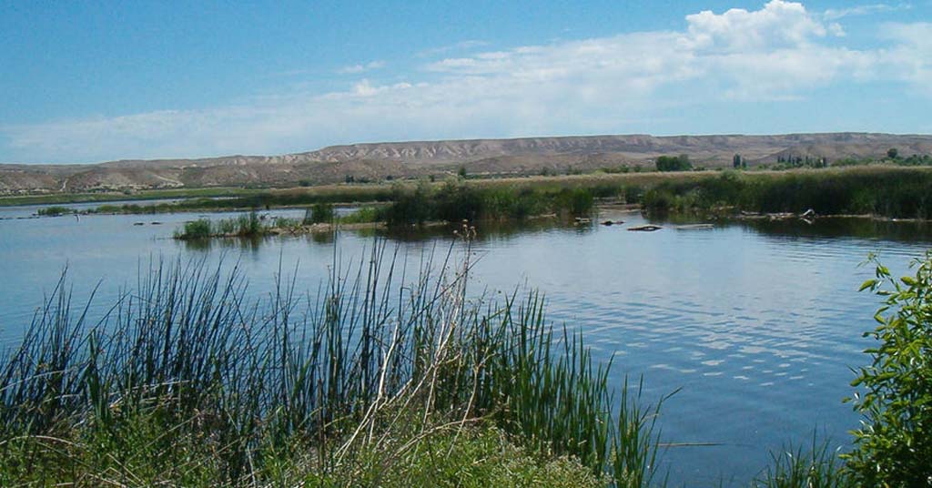
Savings plan: The Deschutes River Basin supplies irrigation water to nearly 59,000 acres of farmland in Jefferson County, Ore. It loses a lot of water through evaporation. Photo: North Unit Irrigation District

By Kendra Chamberlain. April 17, 2024. The North Unit Irrigation District in Central Oregon will be one of the first in the country to build a floating solar energy facility over a canal.

On April 4, the Department of Interior announced the district will receive a $2.55 million award to install floating solar panels over the Main Canal of the Deschutes Project near Bend.

The installation will reduce evaporation losses along the canal while also producing renewable energy.

It’s “an opportunity to save some water and generate renewable energy and revenue based on a resource that was available,” Mike Britton, executive manager at the North Unit Irrigation District (NUID), told Columbia Insight.

Floating solar panels generate energy while shielding water from the sun, thereby reducing evaporation.

A recent study published in the journal Nature estimates that thousands of cities across the world could use floating solar panels to significantly offset carbon emissions without devoting large swaths of land for solar panels.

A handful of floating solar installations exist in the United States, mostly over reservoirs.

Last year, the Medford Irrigation District launched Oregon’s first floating solar project over one of its reservoirs.

More to come?

DOI awarded three other solar canal projects money, including $5.6 million for a project with the Gila River Indian Community in Arizona.

The department and the Bureau of Reclamation are hoping these pilot projects will help iron out the kinks of floating solar systems for future large-scale deployment.

Oregon Senators Jeff Merkley and Ron Wyden touted the project in a statement as proof that Oregon is “driving creative solutions to build the sustainable infrastructure needed for a clean energy future.”

Floating solar panels in California

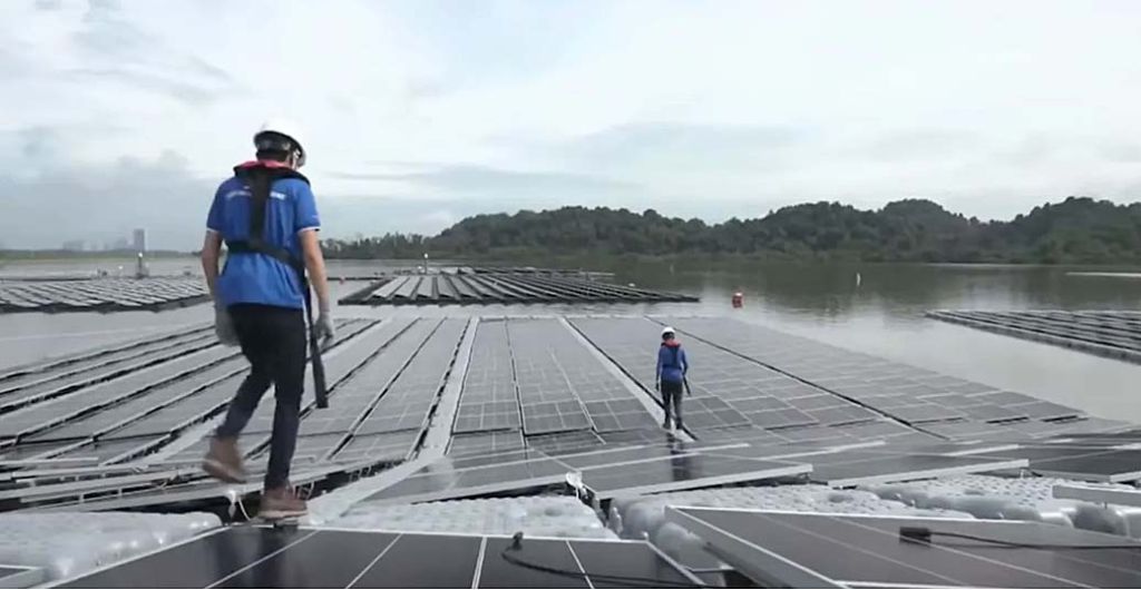
Floating an idea: Scientists at University of California, Merced, are studying the effectiveness of floating solar panels. Photo: UC Merced/YouTube

The North Unit Irrigation District project will produce around 1 MWh of energy that will be fed to the Western Interconnection power grid.

The exact location of the installation is still being worked out.

“This is kind of a new and innovative technology. And it’s part of a larger irrigation modernization effort the North Unit is undertaking,” said Britton. “We’re piping a bunch of our open canals. We have a hydroelectric project, just downstream of this concept here. So we’ve got a lot of moving pieces right now.”

Britton said if the initial installation is a success the district will consider expanding floating solar panels across its canals as it upgrades irrigation systems.

By |2026-02-10T13:00:27-08:0004/17/2024|Agriculture, Energy|1 Comment

Walleyes are causing a lot trouble in the Snake River

Anglers love them but the invasive species could undo years of salmon recovery efforts in the Columbia River Basin

Walleye in Idaho

Space invader: Walleyes are unwelcome in the Snake River. They’re multiplying anyway. Photo: Idaho Department of Fish and Game

By Kendra Chamberlain. April 10, 2024. Fish managers across Idaho, Washington, Oregon and the Confederated Tribes of the Umatilla Indian Reservation and the Nez Perce Tribe have joined forces with NOAA fisheries and the U.S. Geologic Survey to hold off the invasion of nonnative walleye fish before they do any more damage to vulnerable salmon and steelhead populations in the Snake River.

Walleye, the beloved game fish of the Midwest, has been present in the Columbia River system since the 1940s and reached Snake River in the late 1990s.

By then, researchers had realized the species was actually contributing to salmon and steelhead population declines.

Now, the fish are moving into upstream anadromous rearing habitat.

“That’s when it starts getting really concerning,” Marika Dobos, anadromous staff biologist at the Idaho Department of Fish and Game (IDFG), tells Columbia Insight.

Dobos and other fish managers are worried the species could undo the precious progress made on rebuilding salmon and steelhead populations in the Snake River, particularly fall chinook.

In March, Dobos gave a presentation to the Northwest Power and Conservation Council on the walleye invasion and the working group that has convened to stop it.

“Fall chinook nearly blinked into extinction in the Snake River. And a lot of folks have worked really hard to build that program up over the years, and have done a really good job,” Dobos told the council. It’s one of our few success stories in the Clearwater. If the walleye are able to establish in upstream habitats, it could undo a lot of that work in a short amount of time.”

Adept adapters

Walleye are an extremely effective invasive species: they’re good at adapting to different types of environments; they reproduce relatively quickly; and they eat nearly anything they cross paths with.

In fact, it’s not unusual for walleye to eat themselves out of a habitat by decimating populations of native fish.

The walleye’s native prey have spent millenia developing spiny fins to fend off the toothy predators.

But in the Columbia and Snake River systems, the native fish are soft-finned, and thanks to the extensive network of dams throughout the basin, often get caught up in slow-flowing reservoirs and dam bottlenecks as they make their migrations.

It’s a buffet for the walleye.

The fish loiter around the tail races of the dams, eating as much as they can.

Walleye populations have exploded as a result, Dobos says.

There are more predators eating more fish each day.

Fishing favorite

Idaho Department of Fish and Game staff know the walleye have made it past the Lower Granite Dam in eastern Washington.

Dobos says she’s not sure if the walleye have figured out how to pass the dam on their own and are now reproducing upstream, or if they’re being illegally introduced by anglers.

That’s another dangerous trait of the walleye: they’re popular with anglers.

The species’ explosive expansion across the lower 48 has been due in part to fish managers introducing the species into new areas to provide recreational opportunities.

Walleyes are still being stocked in some areas of Washington and Idaho.

Walleye Native Range

Walleye native range indicated in orange. Chart: Marika Dobos/IDFG

Walleye current range

Walleye expanded range indicated by red dots. Chart: Marika Dobos/IDFG

The fish also have a vocal cohort of supporters among the angling community in Idaho.

Anglers illegally introduce the species to new water bodies. Dobos says it’s become common practice for walleye enthusiasts to release any big females that they catch—despite the state asking anglers to keep all walleye they find.

Eradicating the species from the Snake River seems unlikely at this point. But the working group hopes to be able to at least stymie the fish’s progress into the rearing habitats upstream of the dams.

The group had its first meeting in January.

“[That meeting] was just trying to have some discussions about some of the concerns that we had and the values and better coordinating amongst these key agency folks,” Dobos says. But coordinating across so many groups will be a challenge. The first step is to make sure everyone is on the same page.

“This is three different states, there are sovereign nations involved and federal agencies. We think there’s value in making sure that our message is consistent. It’s pretty complex. It’s gonna take a lot of time.”

By |2026-02-09T11:08:49-08:0004/10/2024|Rivers, Salmon|2 Comments

Amid drought, Oregon’s new water ‘strategy’ is light on strategy

As wells run dry, the state says it needs more time and money to crunch numbers. Hard decisions await

Drought in Oregon

Ongoing: Misty Buckley carries dirty water from her animals’ pens to water plants in her yard in 2021 in Klamath Falls. The Buckley’s house well ran dry during the historic drought still impacting much of Oregon. File photo: AP Photo/Nathan Howard

By Kendra Chamberlain. March 28, 2024. “We are not currently meeting Oregon’s water needs.”

That’s how the state of Oregon 2024 draft Integrated Water Resources Strategy begins.

The report’s message is clear—Oregon is facing water scarcity challenges. Stream flows are declining, groundwater in some areas is dwindling and contamination is jeopardizing other water resources.

The 200-page draft document, released earlier this month by the Oregon Water Resources Department (OWRD), delves into water challenges the state faces. The underlying message is hard to ignore: there’s too much demand for too little water.

Six of the last 10 years have been some of the driest the state has seen.

Climate change is “no longer a separate consideration for water management, but rather an integral part of planning, monitoring and project implementation,” according to the draft strategy.

Yet more than 20 years into the ongoing water crisis, there’s another message in the report. The OWRD—the state agency meant “to assure sufficient and sustainable water supplies are available to meet current and future needs”—needs more time and more funding to study the problem.

Wells going dry

In the summer of 2021, about a hundred wells went dry in southern Oregon.

The state began offering free water deliveries to affected homes in hopes of helping families hold out until aquifers recharged during rainy winter months.

But the water never came back.

Over the following year, hundreds more residents reported wells going dry in central Oregon.

There are now roughly 1,200 homes scattered across the state without domestic water supply.

The majority of dry wells have been reported in Klamath, Jackson and Deschutes counties, areas that have also experienced the worst of the drought over the past few years.

These areas have seen increased groundwater pumping by irrigators and decreased aquifer recharge, according to the OWRD.

Oregon snow water equivalent map March 28, 2024

Glimmer: As of March 28, Oregon’s yearly snow water equivalent percentages compared with the 1991-2020 median were above average across most of the state. Map: Natural Resources Conservation Service

But wells are now going dry in counties in the wetter, west side of the state, including in the Willamette Valley.

“Wells across the state are going dry due to a number of factors including record drought, over-allocation of groundwater and limited recharge in some aquifers,” Tim Seymour, assistant groundwater manager at OWRD, told Columbia Insight in an email. “Most of the wells reported dry are domestic wells that are shallow in depth (<100 ft deep) and vulnerable to declines in water levels.”

Groundwater resources around the state are being stretched thin, according to OWRD.

The draft strategy document points out that in most locations in Oregon “groundwater aquifers are no longer capable of sustaining additional development without leading to declining supplies for existing water users and reducing streamflows where surface water and groundwater are hydraulically connected.”

As troubling, groundwater supplies are threatened in areas where the state has seen the most growth in the past decade.

The draft strategy emphasizes that “planning for future development must consider pressures on Oregon’s water resources, in terms of both water quantity and water quality and impacts to the environment and ecosystem services.”

The state is in the midst of revising its groundwater allocation rule to ensure that future groundwater withdrawal permits won’t threaten current supplies or hydrologically connected surface waters.

But the OWRD says it’s difficult to know exactly how much groundwater is left in any of the state’s basins without better data.

Deluge of data

The OWRD says it has multiple data gaps around water resources.

Groundwater allocations have been approved for decades without the state knowing exactly how much water is available; and the state currently isn’t able to track surface water use as closely as it needs for future planning.

The state has access to a network of roughly 600 stream-flow gauges across streams, canals and reservoirs that collect data on water levels in near real time.

But much of that data isn’t processed in a timely manner.

Resort in central Oregon

Central issue: Amid drought, Oregon is rethinking groundwater allocation strategies. Photo: Chuck Thompson

The OWRD says it hasn’t had the capacity to effectively process that data since the 1990s.

According to the department, there are “several years’ worth of water quantity and quality data” that still needs to be processed, analyzed and shared in order to be useful.

“These backlogs in unprocessed data arise largely from limited or inconsistent staffing and resources, shifting agency priorities and data systems, and the complexity of Oregon’s hydrology and geology,” Ben Scandella, hydrogeologist at OWRD, told Columbia Insight in an email.

The state is currently working on developing an online portal for water data that will make sharing data with agencies and the public more streamlined.

But the state will need to invest in managing that data in a way that can support future water planning decisions.

More money

Funding, staffing and resources remain perennial challenges for most of the goals outlined in the Integrated Water Resources Strategy.

The department says funding and staffing have been inconsistent, but also says significant progress has been made in recent years.

“Large water funding packages in the 2021 and 2023 Legislative sessions resulted in resources to make meaningful progress on many of the goals and their supporting actions,” IWRS specialist Crystal Grinnell said in an email. “There is still work to do to address the IWRS goals. There are still gaps in data to help us better understand our water resources.”

The draft document calls for more consistent funding and staffing to help OWRD better manage the water data and engage in inter-agency and local government coordination to ensure water resources aren’t over-allocated.

The final strategy must be adopted by the Water Resources Commission by September 2024 before a work plan can be developed.

In the meantime, the state will finalize new groundwater allocation rules over the next year.

The OWRD is accepting public comment on the draft on the water strategy until April 5.

By |2026-02-09T11:11:49-08:0003/28/2024|Water|2 Comments

Oregon forest board approves controversial habitat protections

The plan should help endangered species but will decrease logging revenues in Coast Range communities and elsewhere

View from atop Kings Mountain summit in the Tillamook State Forest in Oregon.

New protections: As seen from atop Kings Mountain, Oregon’s Coast Range is a checkerboard of clearcuts. And wildlife habitat. Photo: ODF

By Kendra Chamberlain. March 13, 2024. A good compromise leaves everyone unhappy.

That describes the Oregon Board of Forestry’s 4-3 vote last week to move forward with its controversial Western Oregon State Forests Habitat Conservation Plan that will reduce logging on western state forest land to prevent endangered species from going extinct.

The plan is the result of years of work and tough negotiation between the timber industry, environmental groups and county governments, with jobs, millions of dollars in revenue and the potential fate of 17 endangered species at stake.

“I just don’t see a better path,” said board member Ben Deumling at the March 7 meeting during which the plan was approved. “A lot of people have told me there is one, and I wish from the bottom of my heart that that were true. But I don’t see that.”

The final HCP will see about half of western state forestlands, much of it in the Coast Range in northwest corner of the state, set aside for habitat conservation.

Logging interests have claimed this will cost jobs and threaten livelihoods.

Currently, Oregon’s western forests produce 225 million board feet of lumber, and generate nearly $64 million in annual revenue, a percentage of which is distributed across 14 counties.

Under the HCP, logging on western state forestlands is expected to drop roughly 20%, producing an estimated 185 million board feet per year.

Some western counties are expected to see a steep decrease in logging revenue—possibly “multi-million dollar losses,” according to Oregon Capital Chronicle’s Alex Baumhardt.

Still, some new areas will open up for logging under the HCP, which will see other counties generating more timber revenue than before.

Protecting species, avoiding lawsuits

On March 7, a convoy of logging trucks surrounded the Department of Forestry building in Salem to protest the plan while the board heard the state forester’s recommendation and later voted on it.

According to Michael Lang, Oregon policy senior program manager at the Portland-based Wild Salmon Center, environmentalists didn’t get everything they wanted. But it’s still a conservation win.

“The HCP is an improvement in the status quo,” Lang told Columbia Insight. “These state forests have been overharvested for years.”

The state’s western forests are home to 17 threatened or endangered species, including the spotted owl, coho, chinook and steelhead fishes, and the red tree vole and coastal marten.

But only 11% of western state forestland is considered “complex layered forest,” offering important habitat for those species.

Habitat Conservation Plan Area and Permit Area map

Oregon Department of Forestry’s Habitat Conservation Plan Area and Permit Area. Map: ODF

The state has faced multiple ESA-linked lawsuits related to habitat destruction over the years. Adoption of the HCP is expected to decrease its future legal entanglements.

Lang said the HCP will see nearly 50% of state forestlands in western Oregon protected as habitat conservation areas, including areas designated for riparian conservation—but that the HCP isn’t a species recovery plan.

“It’s only designed to prevent the local extinction or extirpation, if you will, of [the endangered and threatened] species. It’s not a forest-wide recovery plan,” he said.

And the plan doesn’t strictly adhere to the best science for habitat conservation. Lang pointed to stream buffers, which help protect cold water. Under the HCP, stream buffers are set at 35 feet.

“The best available science shows that stream buffers should be even larger than they are in the Habitat Conservation Plan, particularly for headwater streams and the coast,” said Lang. “Really, something more like a 50-foot buffer on either side would better protect aquatic species downstream. So that’s just one example of how it’s a compromise.”

The HCP will need to pass hurdles at the federal level to comply with the Endangered Species Act, and will dictate logging on state forest lands for the next 70 years.

Offsetting financial impacts

Gov. Tina Kotek said in a March 5 letter to the board that she’s still working with county representatives to “permanently address the estimated shortfall” from logging revenue declines expected under the plan.

“That work with representatives of the counties continues, but I want you to know that I see a viable pathway forward to address the estimated reduction in timber receipts that would result from implementing the anticipated HCP,” said Gov. Kotek.

Meanwhile, the Oregon House and Senate Republican Caucuses urged Kotek to immediately reconsider the plan.

“This 70-year forest policy does not support a balance between economic, environmental and social benefits to all Oregonians,” the legislators wrote.

By |2026-02-09T12:47:55-08:0003/13/2024|Forestry|0 Comments

A curious Idaho wetlands dispute challenges Supreme Court ruling

The EPA is accusing Ace Black Ranches of Clean Water Act violations but the ranch owners say, huh?

Telby Black of Ace Black Ranches standing in field

Building rights: Telby Black is a partner in Ace Black Ranches, which the EPA says illegally constructed roads in the Bruneau River and adjacent wetlands. The ranch calls the claims unfounded. Screenshot: Idaho Farm Bureau

By Kendra Chamberlain. March 7, 2024. Environmentalists were outraged in May 2023 by a U.S. Supreme Court decision that rolled back protections on the nation’s wetlands.

Last year’s 9-0 Supreme Court ruling in the case of Sackett v Environmental Protection Agency held that “the Clean Water Act extends only to wetlands that have a continuous surface connection with ‘waters’ of the United States.”

The ruling reversed decades of federal policy that widely applied the law to wetlands protections.

“The ruling … has enormous ramifications for the health of the nation’s waterways. In fact, it wouldn’t be hyperbole to call Sackett the most important water-related Supreme Court decision in a generation,” wrote the National Resources Defense Council.

“The decision dramatically narrowed the scope of the Clean Water Act, undoing protections that have safeguarded the nation’s waters for over 50 years,” wrote American Rivers, saying the ruling “erases critical protections for tens of millions of acres of wetlands.”

Now that ruling is being tested as a defense in a legal action the U.S. Environmental Protection Agency has filed against an Idaho ranch.

On behalf of the EPA, the U.S. Department of Justice is alleging that Ace Black Ranches in southwest Idaho violated the Clean Water Act by illegally discharging fill material into the Bruneau River and adjacent wetlands.

The complaint, filed on Feb. 27 in a U.S. District Court in Idaho, claims the ranch illegally mined and processed gravel extracted from the river and used heavy equipment to clear and level dozens of acres of wetlands without a Clean Water Act permit.

But the ranch owners contend those wetlands are no longer under EPA jurisdiction, thanks to the recent Sackett ruling that outlines a very narrow definition of “waters of the United States” in the Clean Water Act.

“There is no basis for the EPA’s claim of jurisdiction over wetlands,” the ranch said in a statement. “Ace Black Ranches’ lawful agricultural activities do not require a Clean Water Act permit and the EPA has no basis for its claims to the contrary.”

The Bruneau River is a tributary of the Snake River.

Portions of the river are protected under the Wild and Scenic Rivers Act, but the river is also used for agricultural irrigation near its confluence with the Snake River.

What violations?

The EPA says the ranch’s activities, which occurred between 2017 and 2021, “significantly” threatened fisheries, neighboring properties and downstream communities, including portions of the state-owned C.J. Strike Wildlife Management Area.

“The complaint in this case alleges that Ace Black Ranches treated the Bruneau River and state-owned wetlands along the river as private property that could be damaged or destroyed for sand and gravel mining, without any effort to comply with the requirements of the Clean Water Act that protects our Nation’s waters from such abuses,” said Assistant Administrator David M. Uhlmann for the EPA’s Office of Enforcement and Compliance Assurance in a statement.

The agency added that the river and its “adjacent wetlands” are subject to protection under the Clean Water Act.

Ace Black Ranches

Back at the ranch: Ace Black Ranches is an 800-acre cattle ranch located in Idaho’s Owyhee County. Screenshot: Idaho Farm Bureau

A video produced in May 2023 by the Idaho Farm Bureau, however, suggests a gross governmental overreach, including intimidation tactics that included “five U.S. marshals, heavily armed” showing up on the ranch property with a sealed warrant and, later, a five-day digging operation on the property carried out by 14 EPA agents.

In the video, ranch partners Telby and Terry Black say that, despite complaints that began in 2019 by an Idaho Fish and Game manager then escalated to the U.S. Army Corps of Engineers then the EPA, they remained, at least up to that point, unaware and uninformed of the nature of the violations in the EPA complaint.

“I asked them for any samples, any information they had to give us, if they found a violation of any kind, and there again they still would not talk to us,” says Telby Black in the video.

“We’d like to fix this problem, and we don’t know what the problem is,” says Terry Black in the video.

A 2021 Idaho Farm Bureau Federation story, however, said the ranch had an idea of the what the issue was.

“Ace Black Ranches has changed our irrigation. We went from flood irrigation to center pivots, so that’s required us to change our roads. That’s required us to do a little more gravel work to fill those roads and tracks to make our irrigation system work,” said Telby Black in 2021.

“The Marshalls were good,” said Terry Black in the same story. “But the Environmentalists were sour.”

What are “adjacent” wetlands?

In the legal proceeding, Ace Black Ranches’ defense is based on the Sackett v EPA ruling.

In that case, the Supreme Court reinterpreted protections for wetlands by determining that wetlands that are adjacent to rivers do not merit protection under the Clean Water Act unless there is a surface-level connection to the river.

The unanimous ruling upended decades of precedent, stripping protections from the majority of the nation’s wetlands.

The ruling also flies in the face of science, according to Nick Kunath, conservation program manager for Idaho Rivers United.

The Clean Water Act’s mandate is “to restore and maintain the chemical, physical and biological integrity of the Nation’s waters.”

But the Supreme Court decision “completely ignores the scientific evidence and basic understanding of how wetlands function and how we have evolved our understanding of their importance,” Kunath wrote in a blogpost last year.

“Wetlands are often connected by groundwater, even if there’s not a continuous surface connection,” Kunath told Columbia Insight.

Idaho's C.J. Strike Wildlife Management Area

Treasured habitat: Located near Ace Black Ranches, the C.J. Strike Wildlife Management Area and reservoir is a popular spot for waterfowl hunting, fishing, camping, boating, wildlife viewing and photography. Photo: Idaho Fish and Game

Even small wetlands play a significant role in riparian habitats, slowing fast-moving water, filtering water and hosting wildlife. The C.J. Strike WMA, for example, is one of the most popular fishing areas in Idaho and is also known for waterfowl hunting.

“Wetlands have often been equated to the rainforests of the riparian areas,” said Kunath. “They’re some of the most biodiverse lands that we have. Whenever we lose wetlands, we have big biodiversity loss.”

Wetlands are relatively rare in Idaho, accounting for only 1-to-2% of landmass in the state.

But they’re important to wildlife. The National Association of Wetlands Management estimates those areas are “critical” for the survival of 80-to-90% of the state’s species.

The state of Idaho does not offer much protection for wetlands and relies on the Clean Water Act’s 401 water certification to regulate impacts to wetlands through the Idaho Department of Environmental Quality.

Idaho state law also prohibits any environmental requirements that are more stringent than federal requirements.

By |2026-02-09T12:46:37-08:0003/07/2024|Agriculture, Industry|1 Comment

Oregon’s ‘thermal trading’ program is popular. Also expensive and unproven

The state lets polluters plant trees to keep river water temps cool. No one knows if the trade-offs actually work

River with fish

Go with the flow? River water is getting too warm for some fish. “Thermal trading” has emerged as a debatable response. Photo illustration: Nicole Wilkinson

By Kendra Chamberlain. February 29, 2024. In 2012, President Barack Obama praised a deal the City of Medford had made with the state to pay for shade trees to be planted along the Rogue River in order to offset the impacts of warm water discharges from the city’s wastewater treatment plant.

“It worked for business, it worked for farmers and it worked for salmon,” Obama said in a speech at the Department of Interior, adding that the plan represents “the kinds of ideas we need in this country.”

To Nina Bell, executive director of Northwest Environmental Advocates (NWEA), the project was a perfect example of all that’s wrong with Oregon’s thermal trading program.

“You can plant all the trees you want on the main stem of the Rogue River and it’s not going to result in any cooling of water. It just isn’t,” Bell tells Columbia Insight. “The trees do not cast shade across the Rogue River in a way that could ever cause any reduction in temperature.”

Bell is one of the program’s biggest critics, but she’s not alone.

WaterWatch of Oregon, a nonprofit advocacy firm that focuses on water quantity, is currently suing Oregon’s Department of Environmental Quality over its approval of another thermal trading plan.

The group argues that the plan is based on flawed modeling and is too vague for DEQ—or the public—to determine whether it would have the intended impact of cooling water temperatures.

In fact, DEQ, which administers water quality trading programs in the state, doesn’t know if any of the thermal trading plans it approves actually work.

What is thermal trading?

Cold water is becoming increasingly hard to find for many Pacific Northwest fish species that have evolved to depend on them, salmon and steelhead included.

Human-driven ecosystem changes like clear-cut logging along mountain streams, municipal, agricultural and industrial discharges, and water withdrawals, have warmed surface waters to dangerously high levels for cold-water aquatic species.

Wastewater discharge pipe

Pipe dream? Some wastewater isn’t just dirty. It’s warm. Photo: Wikipedia

So much so that water temperature fluctuations are treated as a pollutant by state regulators and water temperature is considered a component of water quality.

“In Oregon, we have a unique program in that the pollutant that we are trading for almost exclusively is heat pollution,” says Brian Creutzburg, alternative compliance specialist and basin coordinator at DEQ. “Our streams are too warm and we have set standards for temperature in those streams.”

The state’s thermal trading program attempts to tackle the issue by exchanging pollution permits for projects that promise to cool waters in some areas to offset warmer waters in other areas.

In essence, thermal trading is a mitigation program that allows polluters to continue their damaging activities in exchange for a promise to balance the environmental ledger elsewhere.

These projects often involve riparian restoration and streamside tree planting to help keep waters cool.

Or at least, that’s the idea.

“At best, it’s good in theory. It’s certainly not good in practice, for the most part,” says Bell. “The way they run the program, for the most part, it does not actually have that result [of cooling water] at all.”

Temperature benefits too small to measure

DEQ’s Creutzburg describes the state’s thermal trading program as an “applicant-driven” process.

This means the applicant determines how much temperature needs to be offset, what type of riparian restoration it will pursue to meet that offset and even how the temperature credits will be calculated.

“The water quality trading [program] is a voluntary program. The DEQ sets the parameters of the permits, but we don’t have the authority to tell people how to meet the targets,” says Creutzburg.

Applicants don’t provide DEQ with detailed descriptions of what will be planted, when it will be planted or even where it will be planted—that information is provided to the department in annual reports after approval.

Fish smolt graphic

Cool it: Improving fish habitat is a big part of thermal trading programs. Photo Illustration: Nicole Wilkinson

Instead, DEQ evaluates thermal trading plans for compliance with the state’s water quality trading rules.

“Those rules are pretty straightforward, it goes step by step through the different elements that a plan will need to incorporate,” he says.

Creutzburg says the department conducts in-person visits to verify that specific planting projects are being completed as described in the annual reports.

But DEQ doesn’t measure water temperatures at the sites to determine if any cooling is actually occurring.

In fact, says Creutzburg, DEQ isn’t able to tell if the projects are cooling water at all.

“The benefits from [an] individual thermal trading project will be in the hundredths of a degree,” he says. “That’s essentially way outside the realm of our ability to measure that way. So the way we evaluate efficacy is through modeling.”

DEQ developed a model, called the Shade-a-lator, that uses site-specific information including stream size, canopy density and riparian vegetation to help determine how much sunlight would be blocked through restoration projects.

Applicants run their own modeling to determine the temperature impacts of their permit projects and how much riparian restoration is needed to offset those impacts.

DEQ evaluates applicant models to ensure the modeling used is mainstream and scientifically defensible.

“We do check their work. We have two modelers on staff that I will consult with on an as-needed basis,” he says.

Creutzburg says there’s anecdotal evidence that the streamside planting is working, pointing to areas of riparian restoration that fish seem to be treating as cold water refugia.

“The people who do this work, they see the streams on a regular basis and it’s hard not to notice the fish,” he said. “It is a real effect, scientifically. Unfortunately, we don’t have the perfect information we would like to have on stream temperature at individual streams.”

Planting for ‘ecological uplift’

Clean Water Services is a wastewater management utility in Washington County, Oregon, on Portland’s west side.

The company has engaged in thermal trading projects since 2004. It developed its own in-house riparian enhancement program that handles tree-planting projects along the Tualatin River and its tributaries, rather than relying on environmental consultants.

“We are somewhat different. We do the work ourselves,” Bob Baumgartner, regulatory affairs director at Clean Water Services, tells Columbia Insight.

The company collaborates with the Tualatin Soil and Water Conservation District, private agricultural land owners and public agencies that own park lands for opportunities to engage in riparian restoration projects, which it can then use to generate credits that go toward offsetting thermal impacts of its operations.

Baumgartner says the restoration projects are selected for the broad ecological benefits they will produce, not just shading water to keep it cool.

“A lot of that has to do with creating ecological uplift—ecosystem services is what they call it—where we can get multiple benefits from the shading,” he says. “We look for opportunities for habitat improvement, to improve overall ecological function.”

Oregon's Tualatin River aerial view

Under pressure: In Oregon’s Washington County, water from the Tualatin River is in high demand for agricultural, industrial and urban use. Trees and vegetation cast shadows across the water. Photo: Clean Water Services

Baumgartner says the company also works with entities like the Tualatin River Watershed Council to identify where riparian restoration projects can target protecting or expanding cold water refugia for fish.

Clean Water Services may be considered a poster child for Oregon’s thermal trading program. Attorney Nina Bell points to the company as an example of how riparian restoration can work when it’s well executed.

But even Clean Water Services can’t tell how—or if—its shade projects are directly impacting water temperatures in the restoration areas.

“Stream temperatures are naturally variable, changing throughout the day and from one day to the next depending on weather and location,” says Jamie Hughes, program manager at Clean Water Services’ regulatory affairs department. “It is often difficult to separate out the benefit of the shading from all the other factors influencing temperature.”

Hughes adds that in some project areas, there’s reason to believe their shade planting is helping keep water cooler downstream.

And as long as the project delivers the shade it’s designed to deliver, it’s consistent with DEQ’s thermal trading rules.

Pros and cons

After testing in the early 2000s, Oregon’s thermal trading program was codified in state law in 2015.

Subsequent reviews have been mixed.

One view of thermal trading is that despite its intended public benefits, programs inevitably devolve into market-driven mechanisms.

In this condition, accountability dwindles and thermal trading programs are seen simply as a way to allow polluters to avoid the expense of constructing cooling towers and storage lagoons or implementing other mitigation strategies before discharging heated water into rivers and streams. [A previous version of this story incorretly stated that wastewater utilities heat water during the treatment phase. According to Oregon DEQ: “The heat pollution discussed in the article comes from all of us, e.g., everyone who showers with hot water, uses hot water to wash dishes, etc. In other words, the heated water comes from water heaters in people’s homes.” —Editor]

Natural disasters, such as the wildfires that tore through the Willamette Valley in 2021, can and do wipe out riparian buffers.

Importantly, riparian canopies don’t actually cool water; they only prevent it from warming.

For various reasons, the state of Washington has declined to follow Oregon’s lead, though it has considered thermal trading programs.

“While thermal trading is certainly something that comes up to try to address temperature pollution, there haven’t been any proposals to us over the past decade to start a thermal trading program,” Washington Department of Ecology Water Quality Communications Manager Colleen Keltz told Columbia Insight in an email. “Ecology considers the most logical pollutants for trading are phosphorus, nitrogen other oxygen-related pollutants and sediment. We will consider trades involving temperature, although the lengthy time lag to produce shade may prohibit temperature trades in many watersheds.”

[perfectpullquote align=”full” bordertop=”false” cite=”” link=”” color=”” class=”” size=””]Absent important details, the public can’t truly weigh in on the efficacy of thermal trading plans.[/perfectpullquote]

Proponents of thermal trading (occasionally referred to as “shade trading”) point out that traditional methods of decreasing the temperature of treated wastewater with cooling towers and storage tanks require enormous amounts of energy, concrete structures and other environmentally disruptive activities.

Erecting massive infrastructure, in effect, amounts to a mechanical fix for a natural problem.

Wastewater has to go somewhere, all disposal systems are imperfect and temperature is just one facet of water quality.

Because temperature is easy to measure, track and regulate, a system has been built around it.

Yet a diverse riparian habitat delivers far more than just temperature benefits.

In focusing on the shortcomings of thermal trading programs, supporters say critics are blinding themselves to the broader good—that “ecological uplift”—they provide.

Watching the bottom line

In Oregon, The Freshwater Trust has emerged as a leader in implementing thermal trading programs for utilities and other large polluters, earning $5.3 million and $4.7 million through its water quality trading services in 2020 and 2021, respectively, according to its IRS filings.

The Portland-based nonprofit has contracted with the City of Medford, City of Ashland, Metropolitan Wastewater Management Commission of Eugene-Springfield, Portland General Electric, Idaho Power Company and others with a goal to, in at least one case, “promote implementation of agricultural best practices that enhance freshwater ecosystems and improve farmers’ bottom lines.”

According to a post on The Freshwater Trust’s website, “Chillers and storage lagoons can cost millions of dollars just to build, whereas natural infrastructure alternatives are often the lowest cost alternative over time.”

In 2021, it estimated the City of Medford would have had to spend “upwards of $20 million” in 2011 to invest in a cooling tower or chiller. Instead, “the city partnered with TFT to the tune of $6.5 million.”

But the question remains, to what degree did those thermal trading programs decrease water temperatures?

The Freshwater Trust declined several requests over a period of weeks to comment on this story or explain how it measures the success of its programs.

Mischief in modeling

WaterWatch’s lawsuit is over a thermal trading plan DEQ approved in 2018 for the Willamette Water Supply System (WWSS) in connection to its proposal to withdraw up to 150 million gallons of water per day from the Willamette River over the next 60 years.

The Willamette River already fails to meet state water quality standards because the water in the river reaches temperatures deemed by the state to be too hot for cold-water species.

DEQ acknowledged that WWSS’s water withdrawal proposal would further raise the temperature of water in the Willamette and asked WWSS to address those temperature impacts.

WaterWatch alleges WWSS and the consultancy firm it hired dramatically underestimated the temperature impacts its proposal would have on the river in its modeling assumptions in order to reach a more palatable thermal trading plan.

“The assumptions that we think the model should have included, what was the most reflective of their actual impact, would have required [WWSS] to do about 40 miles of streamside shading or of riparian restoration. They cut that number down to three miles of shading,” WaterWatch staff attorney Brian Posewitz tells Columbia Insight. “It’s a really graphic illustration of how much they reduced their obligation and then DEQ just went along with that.”

WaterWatch also contends that the thermal trading plan that WWSS submitted based on its modeling was too vague to be effectively evaluated.

Posewitz argues thermal trading plans approved by DEQ “just sort of described general approaches that might work to offset the impact as opposed to, ‘here’s the project we’re going to do, and here’s how much offset we’re going to create.’

“Our position is that when you approve these plans, you’re supposed to be making a determination that the plan is going to offset the impact that the applicant is having,” he says. “If the plan is inadequate, they are violating water quality laws.”

As it stands, Posewitz doesn’t believe DEQ can know whether or not WWSS’s thermal trading plan will result in the intended temperature offsets, because the department doesn’t require enough information to make that determination.

And without those important details, the public can’t truly weigh in on the thermal trading plan, either.

“There’s a lot of potential for thermal trading to be manipulated and misused in a way such that the temperature impact needing to be offset really isn’t offset,” says Posewitz. “There’s a lot of devil in the details.”

Columbia Insight’s reporting on biodiversity in Oregon is supported by the Autzen Foundation.

By |2026-02-09T12:51:28-08:0002/29/2024|Waste Management, Water|3 Comments

© Copyright 2013-2025 Columbia Insight. All Rights Reserved.

As a 501(c)3 nonprofit organization, all donations to Columbia Insight are tax deductible to the full extent of the law. Our nonprofit federal tax-exempt number is 82-4504894.