Stay Updated Subscribe today for the latest research + reporting about environmental news. Subscribe Now

Stay Updated Subscribe today for the latest research + reporting about environmental news.

Subscribe Now

Jurgen Hess

Jurgen Hess

Jurgen Hess

About Jurgen Hess

Jurgen Hess is a photojournalist specializing in wildfire photography. He is a member of the Columbia Insight Board of Directors.

Town of Lyle forced to evacuate due to fire in National Scenic Area

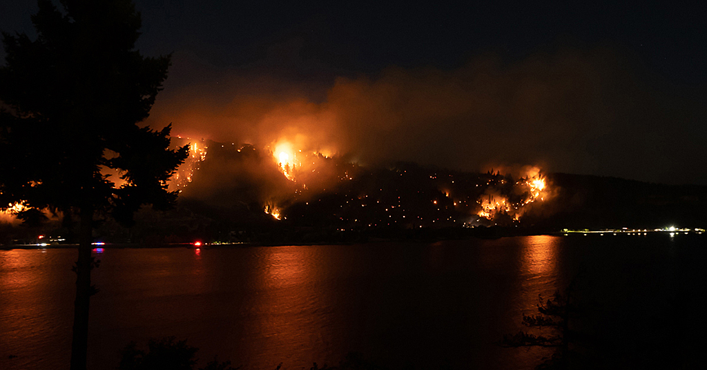
The Burdoin Fire forced residents to flee. Despite the furious efforts of firefighters, the inferno continues to roar

Burdoin Fire, July 18, 2025

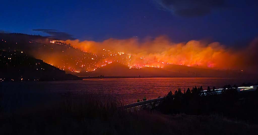
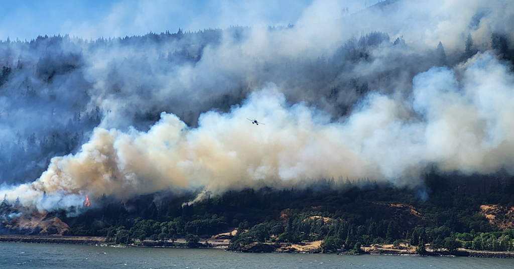
Red glare: The Burdoin Fire, seen across the Columbia River from the Historic Columbia River Highway east of Mosier, Ore., continues to burn. Photo: Jurgen Hess

By Jurgen Hess. July 21, 2025. The Burdoin Fire erupted on July 18 at 2:29 p.m., about two-and-a-half miles east of White Salmon, Wash., not far from Burdoin Mountain.

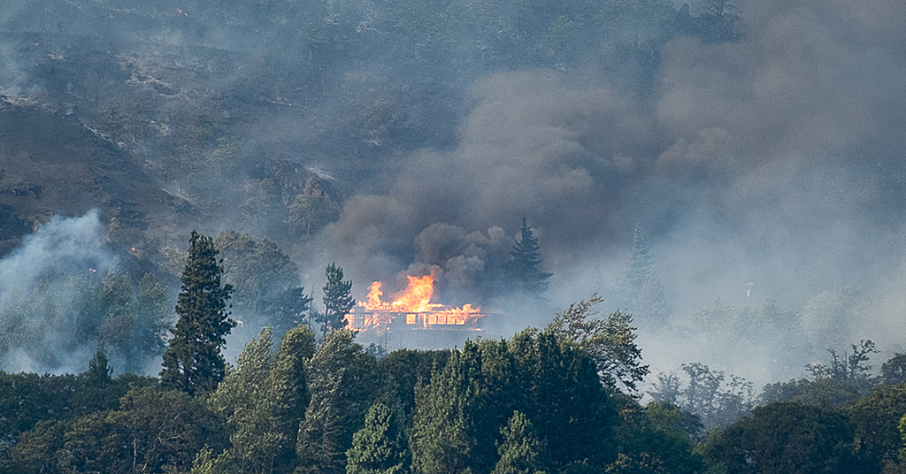
As of this afternoon, the fire, which is burning on both sides of Washington State Route 14 within the Columbia River Gorge National Scenic Area, has burned over 10,500 acres and destroyed 14 homes.

The highway remains closed from mile marker 66 east of Bingen to mile marker 76 west of Lyle.

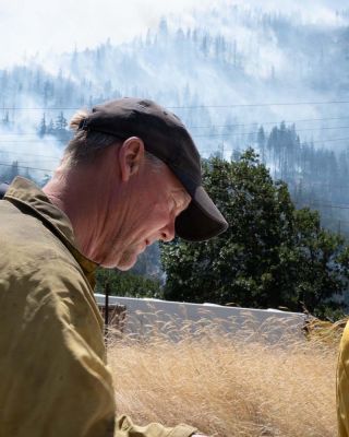
Roland Rose, the U.S. Forest Service, Columbia River Gorge National Scenic Area’s fuels manager, told Columbia Insight the fire started close to the junction of State Route 14 and Courtney Road in Klickitat County.

The cause of the blaze has not yet been determined.

Burdoin Fire from Rowena Crest

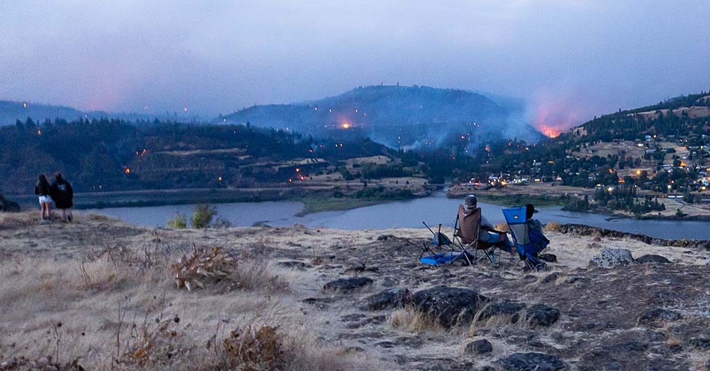
Spectacle: Onlookers watched the Burdoin Fire from Rowena Crest Overlook in Oregon on July 19. Photo: Jurgen Hess

Complex Incident Management Team Northwest 13 assumed command of the fire from the Washington Department of Natural Resources this morning.

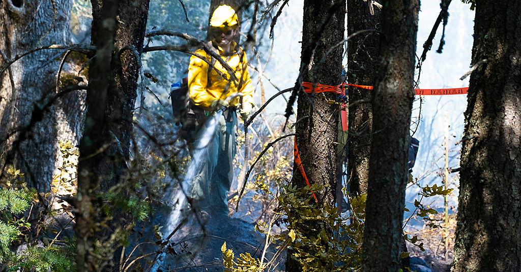
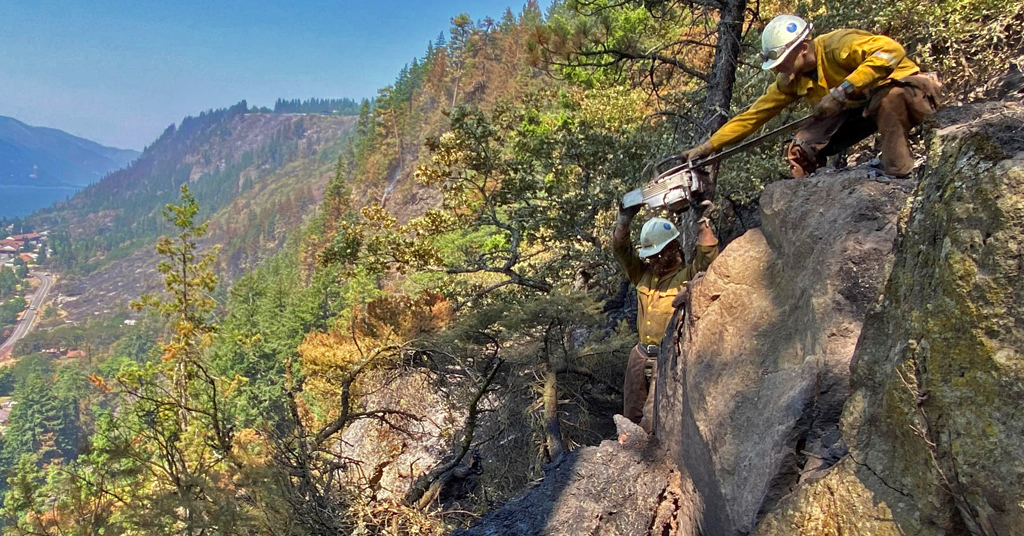
Firefighting work has been supported by the USFS, Washington State Fire Mobilization, West Klickitat Regional Fire Authority and Klickitat County Fire District 4-Lyle.

According to InciWeb (an interagency all-risk incident information management system), the Burdoin Fire “is being managed as a full suppression incident. Primary objectives are to minimize impacts to communities and community infrastructure in Bingen, Lyle and High Prairie, Yakama Nation lands and natural resources.”

“Go now!”

On Saturday, the Klickitat County Sheriff’s Office declared the town of Lyle (pop. 321) at Evacuation Level 3 (“Go now!”), compelling residents to leave the area immediately.

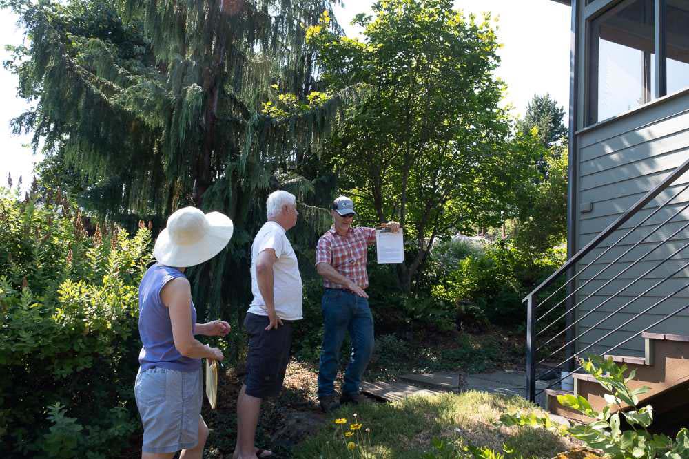
“At 11:30 a.m., Saturday, police sirens went off all over town,” botanist, Columbia Gorge activist and Lyle resident Barbara Robinson told Columbia Insight. “I was delighted with the police notification response. They did a good job.”

Asked what items she took from her home, Robinson said, “I might never see this house again. If a fire started (here), I don’t think the town would be saved. I took my computer, photos, my Reed College yearbook, underwear and a toothbrush. And my bag of balsamroot seeds.”

Burdoin Fire fire retardant air drop

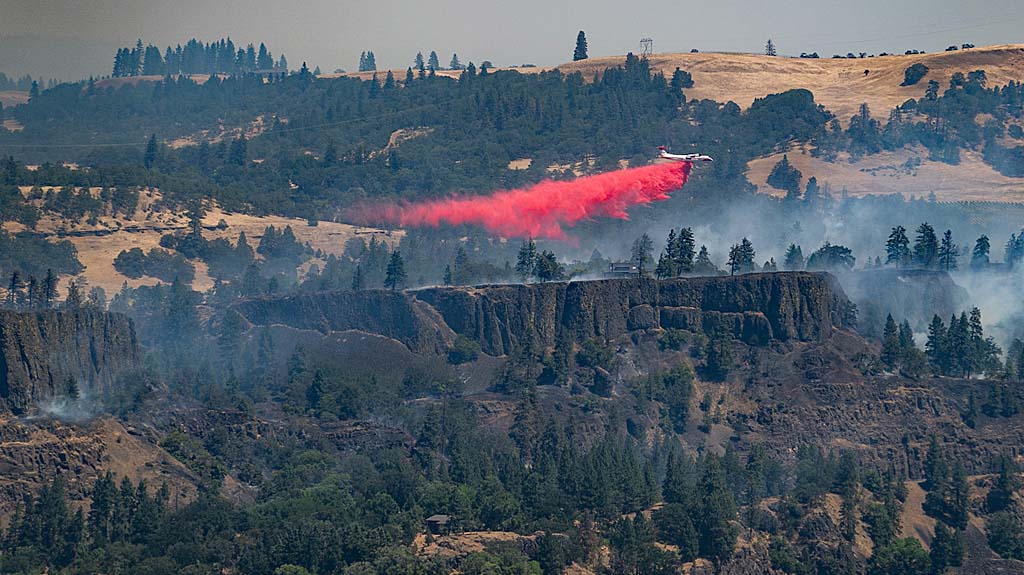
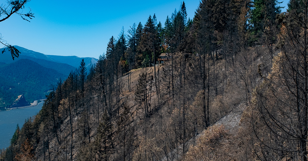
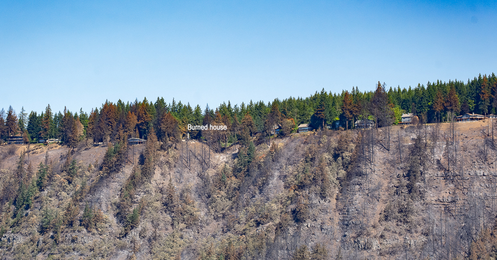
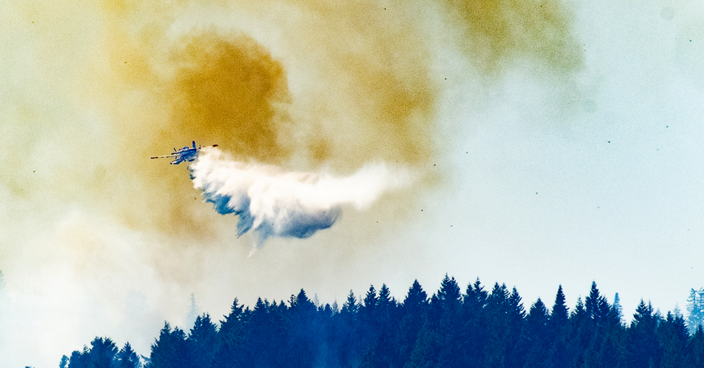
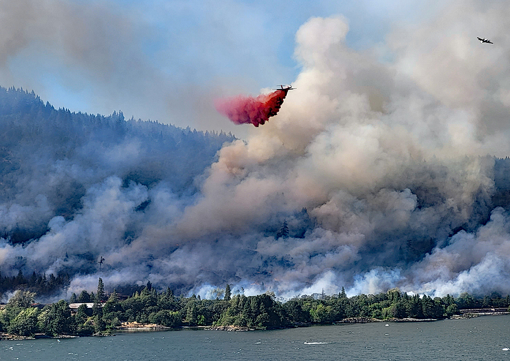
Drop zone: Airplanes unloaded fire retardant on the blaze. This drop helped save a house that remains standing. Photo: Jurgen Hess

Short grass, brush and timber are fueling the Burdoin blaze.

“The next time a fire comes, it will be like Paradise,” said Robinson, referring to the California town that burned in the 2018 Camp Fire that lasted 18 days, killed 85 people and destroyed more than 18,000 structures. “It’s set to burn.”

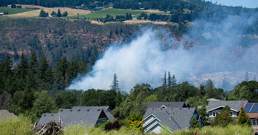
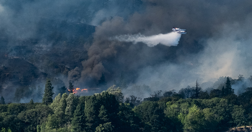
The westerly movement of the fire appeared to have been slowed with an air attack on the night of July 18, with airplanes and helicopters scooping water from the Columbia River and dropping it on the blaze.

Air attack planes making numerous fire-retardant drops included twin-engine water scoopers operating out of Redmond, Ore., and single-engine Fire Boss aircraft.

Rose told Columbia Insight that in some areas treated in recent years by the USFS to reduce fire-prone fuels, the blaze had been slowed or even turned back.

By July 20, however, the fire had crossed the Klickitat River and was burning across the Centerville Highway, just north of State Route 14.

Lyle, Washington

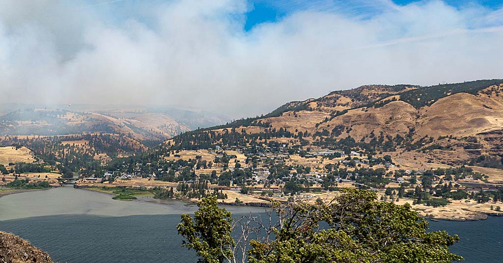
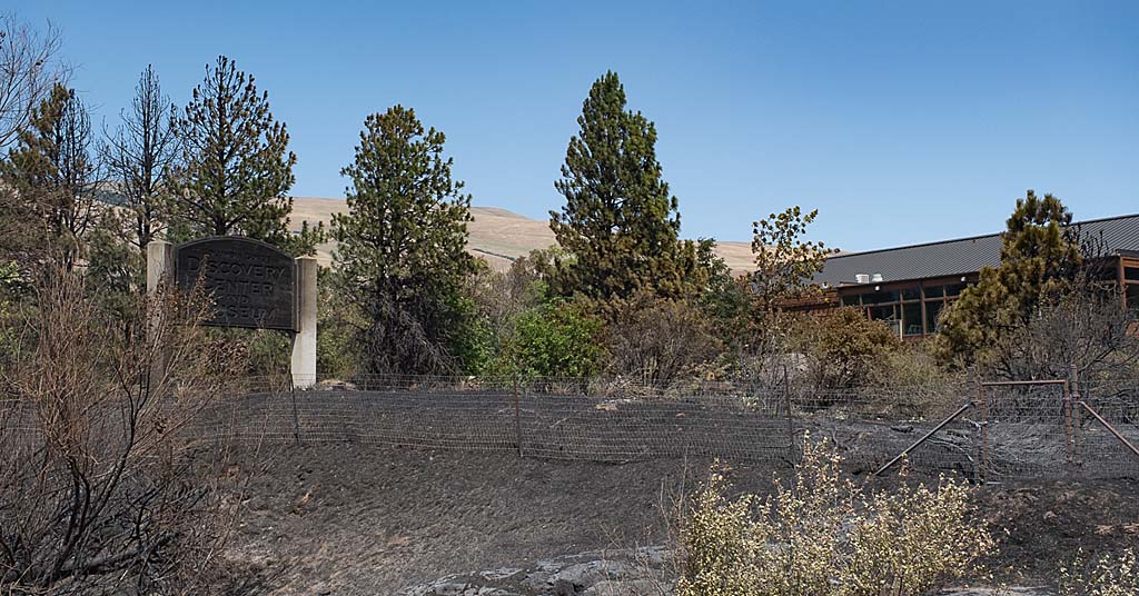
Smoke screen: Residents of Lyle, Wash., remain evacuated but firefighters have been able to prevent the blaze from reaching the town. Photo: Jurgen Hess

The fire is primarily moving to the north and northeast in steep terrain.

Thanks to the work of aircrews dropping water, the fire hasn’t moved into Lyle.

But there’s no end in sight. Officials say the fire is 0% contained.

By |2025-12-23T12:33:41-08:0007/21/2025|Wildfire|Comments Off on Town of Lyle forced to evacuate due to fire in National Scenic Area

Rowena Fire claims historic house, causes evacuation of animal shelter

Burning more than 3,500 acres in the Columbia River Gorge, the blaze continues to consume resources and Scenic Area land

Rowena Fire June 2025

Scenic disaster: The Rowena Fire in the Columbia River Gorge National Scenic Area, seen here from across the river near Lyle, Wash., started on June 11. Photo: Lesley Lamb

UPDATE: On June 23, 2025, two residents filed a lawsuit alleging that the Rowena Fire was caused by a Union Pacific train on June 11 when a train “emitted superheated particles and ignited dry brush and other vegetation” about three miles northwest of The Dalles. “After conducting its own extensive investigation, Union Pacific has found no evidence to date that our train caused the Rowena Fire,” Union Pacific said in statement, also saying it is “fully cooperating with state investigators.” —Editor

By Jurgen Hess. June 16, 2025. On June 12, twin-engine amphibious planes roared 200 feet above a media briefing in Mayer State Park in The Dalles, Ore., almost drowning out the voices of officials as they attempted to convey information.

The planes were scooping up Columbia River water—1,620 gallons per run—to drop on the Rowena Fire, which started on June 11.

The blaze near the town of Rowena in the Columbia River Gorge National Scenic Area along Highway 30 west of The Dalles, has since grown to 3,636 acres.

USFS Incident Commander Roland Rose

Response time: USFS Incident Commander Roland Rose prepares for a media briefing after the start of the Rowena Fire. Photo: Jurgen Hess

According to the Wasco County Sheriff’s Office, 56 houses have been destroyed and 4,000 homes remain under some level of evacuation order.

Initially managed by the U.S. Forest Service, the Oregon Department of Forestry has since assumed management of the fire.

“The focus is on protecting structures,” said Roland Rose, the USFS’s incident commander.

The fire started on Wednesday, June 11, at 1:30 p.m. on land adjacent to Union Pacific railroad tracks and Interstate 84, a mile and a half west of Rowena.

Westerly winds of 25-to-30 mph blew flames east on both sides of I-84.

As of June 15, the fire was 24% contained, and still burning on the steep slopes south of Highway 30.

The fire has been determined to be human-caused. Investigators are analyzing the area.

According to the Oregon Department of Forestry, 726 personnel have been engaged to fight the fire, along with 47 fire engines, nine helicopters, three twin-engine “water scooper” aircraft and two bulldozers. The size of the fire was determined by nighttime, infrared aerial photography.

Ore. Gov. Tina Kotek invoked the Emergency Conflagration Act authorizing the Oregon State Fire Marshal to mobilize structural-protection fire crews from the entire state to assist and protect houses.

Information on the Rowena Fire is available at Inciweb.

Animal shelter evacuated

The fire spread to the south side of the Columbia Gorge Discovery Center & Museum in The Dalles, Ore. While the center was not harmed, its sign on I-84 was burned.

Adjacent to the Discovery Center, the historic Fulton-Taylor House was completely burned.

Marion Taylor famously painted her house pink to thumb her nose at the Columbia River Gorge Commission, which was established in 1987 to help manage the Columbia River Gorge National Scenic Area.

Fulton-Taylor House burned

Colorful past, grim present: The historic Fulton-Taylor House was obliterated by the blaze. Photo: Jurgen Hess

Now owned by Friends of the Columbia Gorge, the house was repainted tan to blend in with the natural environment.

“We are trying to find living accommodations for the house tenant,” Friends of the Columbia Gorge Executive Director Kevin Gorman told Columbia Insight.

Shortly after the fire broke out, Columbia Gorge Humane Society volunteers evacuated dozens of dogs and cats from the organization’s animal shelter in The Dalles. Staffers from the City of The Dalles and Fun Country Powersports assisted in the evacuation.

The evacuation to private boarding facilities in or near The Dalles took about two hours.

The shelter area was later placed under a Level 1 evacuation warning, the lowest level, allowing animals to be transferred back to the shelter on Friday and Saturday.

It’s burned before

The current Rowena Fire area burned in August 2014 in a blaze also named the Rowena Fire. That fire destroyed one house.

Fire season has started early in 2025, with fires burning across the Pacific Northwest.

“Conditions are like it’s August,” said Oregon State Fire Marshal Travis Moderna.

Columbia Gorge Discovery Center & Museum sign burned

Close call: The Columbia Gorge Discovery Center & Museum sign was ruined by flame. The center itself was unharmed. Photo: Jurgen Hess

Fires often re-burn land as vegetation regrows.

The rate of re-burn of old fire areas is especially high in dry eastern Oregon.

By |2026-01-08T14:38:10-08:0006/16/2025|Wildfire|Comments Off on Rowena Fire claims historic house, causes evacuation of animal shelter

Small fire, big wake-up call

In Hood River, a tiny fire sounds the clarion call for wildfire preparedness

Hood River fire, smoke plume

It can happen here: A blaze in a Hood River neighborhood highlighted the importance of fire preparedness. Photo: Jurgen Hess

By Jurgen Hess, July 17, 2024. “It’s a wake-up call.” That’s how Hood River, Ore., homeowner Jennifer Wilson described a July 11 blaze adjacent to her house. The fire caught her and her neighbors unaware.

“I never thought this would happen,” she told Columbia Insight.

The fire, tiny at one-half acre, burned brush and oak trees on private land, and came within 150 feet of Stonehedge Gardens restaurant.

Hood River County Sheriff Matt English designated the area around the fire a Level 2 evacuation zone, meaning residents in the zone should ready to evacuate.

English and county deputies patrolled residential neighborhoods next to the fire and closed the streets to non-residents.

Because of the fire’s adjacency to homes, six firefighting agencies responded to the fire, with the Hood River Fire Department taking the lead.

Firefighting urban blaze

Mop up: Red flagging indicates the fire’s point of origin in Hood River. Photo: Jurgen Hess

Roland Rose, fire manager with the U.S. Forest Service Hood River office, reported that the fire was human caused, ”very likely at a homeless camp.”

Homeowners at the fire’s east edge stood outside watching firefighters hand-clearing fire lines adjacent to their houses. They acknowledged the fire came as a shock.

“We weren’t prepared for this,” said homeowner Jim Wood.

Wilson’s house is adjacent to a large area of unmaintained brush and grass. The land is planned for residential development, but is severely overgrown with fire-hazardous materials.

Wilson said she planned to organize a meeting of neighbors and the Oregon State Fire Marshal.

The Fire Marshall provides advice on protecting homes from fire, including brush and grass trimming, limbing up trees and replacing flammable bark with rock adjacent to homes. Homeowners can schedule a fire reduction visit at the Oregon State Fire Marshal’s website.

Hood River overgrowth near homes

Burnables: Hood River resident Jennifer Wood surveys blackberry and tall grass next to her house. Her home was in the evacuation zone. Photo: Jurgen Hess

Homeowners in fire-prone, dry western states—even in urban areas—should be prepared to evacuate their homes and have a “Go-Kit” that includes water, food, valuable papers, medicines, phones and chargers, laptops, food, cash and credit cards and sanitation items.

While Stonehedge Gardens and houses were saved and the fire was small, it’s urgent that homeowners do fire hazard reduction work around their homes. This is the heart of wildfire season.

“We’ve got work to do,” said Wilson.

Jubitz Family Foundation logoColumbia Insight’s reporting on environmental issues in Oregon’s Hood River Valley is supported by the Jubitz Family Foundation.

By |2026-01-13T15:39:02-08:0007/17/2024|News|2 Comments

Why Washington’s Tunnel 5 Fire is destined to be repeated

Without a major policy shift, more private homes will burn and more public money will be spent trying to protect them

Not all can be saved: A Fire Boss amphibious air tanker dumps 200 gallons of water over the Tunnel 5 Fire. The house in flames (left) and another home (obscured by smoke) directly beneath the water drop were completely destroyed. Photo: Jurgen Hess

By Jurgen Hess. August 3, 2023. On July 2, the Tunnel 5 Fire began in Underwood, Washington, about two miles west of the town of White Salmon in the Columbia River Gorge National Scenic Area.

Before being 80% contained by mid-July, the fire scorched 529 acres and destroyed 10 structures, mostly homes. At least 40 fire engines, 256 firefighters and other personnel, five helicopters, six dozers and 16 water tenders were employed to fight the blaze.

The cost is still being calculated, but a single retardant drop by jet airplane on the Tunnel 5 Fire cost as much as $12,400.

The expense for fighting the 2017 Eagle Creek Fire on the Oregon side of the Columbia River Gorge eventually reached $40 million.

For two weeks, the Tunnel 5 Fire provided a shocking and unsettling sight as flames and smoke billowed above a stretch of the Columbia River dotted with large, cliff-top homes.

But it was hardly unprecedented.

In 2007, the Broughton Fire burned 200 acres and seven structures (including five houses) in the precise location.

That fire was caused by the BNSF Railway Company’s grinding of nearby railroad tracks. “Track grinding” or “rail grinding” repairs deformities and corrosion of rail tracks due to heavy use. The process creates sparks.

The cause of the Tunnel 5 Fire remains under investigation.

Close call: The Tunnel 5 Fire blew up steep slopes carried by fuels of trees, shrubs and grass. This house was fortunate to be spared from the fire. Photo: Jurgen Hess

Two wildfires in the exact location in just 16 years—is this simply a coincidence, a supreme stroke of bad luck?

Unfortunately no.

The Broughton and Tunnel 5 Fires burned, proved so difficult to fight and were wildly expensive to contain for similar reasons.

Might another catastrophic blaze burn in the same area in the near future?

Unfortunately it’s likely.

The reasons have to do with the geography of the area around Underwood and particular regulations that govern private property in the National Scenic Area.

But they also point to broader issues involving the encroachment of residential homes in heavily forested areas, and the way the U.S. Forest Service currently prioritizes private real estate (i.e., houses) over public resources (i.e., trees and surrounding habitat) when fighting fires.

Is such a policy wise? Is it in the public’s interest?

With national insurance companies beginning to refuse to issue policies for homes in some parts of the country due to “growing catastrophic exposure,” is it time to reconsider the construction of houses in fire-prone areas and the way we fight nearby fires when they inevitably come?

Recipe for disaster

Located along Washington State Route 14 at the confluence of the White Salmon and Columbia Rivers, Underwood is an unincorporated community within the Columbia River Gorge National Scenic Area. Its position atop a set of bluffs commands fantastic views of the Columbia River Gorge and, across the river into Oregon, Mount Hood.

But the bluffs atop which the community sits are so steep they form a nearly vertical wall.

In summer, these slopes are covered with highly flammable dry grass, brush and trees. One source of ignition and a decent wind are all that’s needed to send fires roaring up the hillside. (In the first days of the Tunnel 5 Fire, winds gusted between 35 and 40 mph.)

Heaven meet Hell: Slopes below Cook Underwood Road burned right up to the hilltop houses. Photo: Jurgen Hess

At the bottom of the bluffs, SR-14 and adjacent railroad tracks—both proven and potent sources of ignition—parallel the river.

At the top of the bluffs, Cook Underwood Road is lined with over 50 houses, each surrounded by forest, trees and brush.

The recipe for disaster is obvious.

“We can’t stop the fires, [we] shouldn’t build there,” Robin Dobson, a retired U.S. Forest Service ecologist who worked in the Columbia River Gorge National Scenic Area for 24 years, told Columbia Insight after the Tunnel 5 Fire. “We need to use our common sense.”

“Nobody thinks [fire] can happen to them, but the reality is that it does,” said Dan Harkenrider, USFS National Scenic Area manager from 2001 to 2011.

How Firewise are we?

In 2002, recognizing the growing problem of wildfires in rural residential areas (especially California), the National Fire Protection Agency created an educational program called Firewise Communities USA. The idea was to teach homeowners best practices for how to live “fire wise” in Wildland Urban Interface (WUI) areas as a way to mitigate potential wildfire losses.

Firewise measures include removing shrubbery and trees close to home ignition points by creating a “lean, clean and green landscape” zone; using fire-resistant building materials; screening house vents; and keeping gutters free of burnable material.

Dan Richardson, Underwood Conservation District, Climate and Community Resilience lead, administers the Firewise program in Underwood by doing a wildfire home hazard assessment.

Firewise home review in Columbia River Gorge

Passing grade: Dan Richardson (right) conducts a Firewise review at the Columbia River Gorge home of Luci Walker and Kevin Widener. Photo: Jurgen Hess

On a recent visit to the home of Luci Walker and Kevin Widener (north of Cook Underwood Road, not in the immediate area of burned houses), Richardson walked around the perimeter of the home looking for vegetation too close the house.

After explaining that most house fires are started by glowing embers, he noted that all vents in the house were well screened and that the house siding was made of unburnable cement board. The gutters were largely empty of burnable debris. There was no bark dust, which is very flammable.

A small juniper plant was recommended for removal.

A question arose of what to do about a long line of large Douglas fir trees on the east property line. Those trees could carry a crown fire.

Richardson concluded that picking up limbs and debris, cutting branches to a height of 10 feet and thinning out smaller trees would help reduce fire risk.

Overall, the homeowners got a report that the house met Firewise standards, with a few recommendations for improvement.

Conflicting guidelines

The Columbia River Gorge National Scenic Area Management Plan includes provisions for implementing Firewise practices.

“The reviewing agency shall provide information on Firewise standards to landowners at the time of application (for a building permit),” states the plan. “Landowners shall be encouraged to incorporate Firewise standards in their proposal.”

Fire-risk directions are also included in the Gorge Commission’s recently adopted Climate Change Action Plan.

But Lisa Naas Cook, a planner with the Gorge Commission, says meeting National Scenic Area standards of scenic preservation and reducing fire risk is a tricky dance.

That’s because homeowners in the Gorge are bound by National Scenic Area Management Plan regulations that require houses be screened with trees or other vegetation to meet scenic-protection measures.

Air war: Black spots in the sky during the Tunnel 5 Fire are hot embers driven by upslope winds. During wildland fires, embers are the primary ignition source for house fires. Photo: Jurgen Hess

In a way it feels like a trap, with Firewise and National Scenic Area guidelines appearing to be at odds.

“Absolutely there is a conflict between fire safety (and scenic standards),” said ecologist Dobson.

Cook said the Commission plans to take a closer look at the issue during its next Management Plan review.

According to the Gorge Commission’s website, the Commission can amend its plan “if it finds that conditions in the National Scenic Area have significantly changed.”

At this time, however, there is no proposal on record to amend the plan.

During the public input phase of the Climate Change Action Plan development, several members of the public argued for more stringent standards to reduce fire risk.

Janet Wainwright, a former Gorge commissioner, wrote: “Mandate (not suggest) all new construction adhere to Firewise standards. Make this one of the requirements of application approval.”

But such measures can do only so much to prevent wildfires from burning homes built within forests and other wilderness areas.

“Homeowners who live in forested settings must take responsibility and prepare their property to survive wildfire rather than relying on firefighters to save their homes,” said Jack Cohen, a USFS research scientist. “Because during intense fire conditions firefighters will likely be overwhelmed.”

Private property vs. public treasure

When fighting fires, USFS policy dictates that saving human lives is the top priority, followed by saving property, such as houses and businesses.

This became a problem when the Tunnel 5 Fire struck. Firefighters weren’t sent onto the steep slopes below the Underwood houses due to safety risks.

“It’s just too hazardous for firefighters to work on the steep ground,” Bobby Shindelar of Northwest Incident Management Team 12 told Columbia Gorge News.

Instead, at a great financial cost, aircraft dropped water and retardant on the steep slopes.

Extreme slopes: It’s not just flames and smoke that imperil firefighters. Treacherous inclines, like those faced by these Tunnel 5 firefighters, introduce another level of danger. Photo: Wash. DNR

Firewise is good practice, but after an event like the Tunnel 5 Fire it’s reasonable to wonder how much homeowners can realistically do to prevent the loss of property constructed in such an obviously precarious place.

Shifting attitudes of insurance companies may also become a factor in the way we view fighting fires.

On May 26, State Farm Insurance announced it would no longer accept applications for home and business insurance in California due to “historic increases in construction costs outpacing inflation, rapidly growing catastrophe exposure and a challenging reinsurance market.”

Some of those increased construction costs and catastrophic exposures are related to high fire risk and requirements to make new homes fire-safe.

In conversations with Columbia Insight, County Commissioner Tom Lannen, Scenic Area Manager Harkenrider and several Tunnel 5 firefighters said they believed insurance policies would be a “check” and on future construction in fire-hazard zones.

But David Waymie, director of the Skamania County Public Works and Planning Department, which administers building permits in the area of the Tunnel 5 Fire, said his department is unlikely to require fire-protection measures for homes being rebuilt in the wake of the fire.

But, he said, “there is a risk in living in the forest. While the view is tremendous, there is a fire danger.”

Homeowners in Skamania County have two years to start the process of replacing a burned house.

Same old, same old?

Another fire in Underwood is likely because conditions that led to the previous two fires will remain stable.

SR-14 isn’t going anywhere. Neither are the railroad tracks nor the steep, vegetated cliffs directly below the community.

For maybe 10 years or so after a fire, fuels and risks are lower. But with hotter and dryer weather fire risk is increasing, especially on these slopes,” said Lorretta Duke, South Zone fire management officer of the Gifford Pinchot National Forest, a portion of which is located in Skamania County.

Duke also points to rail-grinding operations. “Consider timing of grinding to not do that during high fire danger times,” she said.

“There needs to be conversations with Burlington Northern as to their track-grinding procedures,” Skamania County Commissioner Tom Lannen told Columbia Insight when asked about preventing future fires in the area.

Others are more blunt in their assessment of construction and rebuilding of houses destroyed or damaged in areas of high fire risk.

“It seems crazy to build a new house in this fire-risk zone,” said Harkenrider. “Where is the line where people shouldn’t be allowed to build?”

By |2025-12-31T10:31:53-08:0008/03/2023|Wildfire|12 Comments

Columbia Gorge fire burning uncontrolled; homes threatened

Airplanes and helicopters have been deployed to battle the Tunnel 5 Fire on the banks of the Columbia River in Washington

Fire Boss aircraft fights Tunnel 5 fire

An Air Tractor Fire Boss emerges from a cloud of smoke created by the Tunnel 5 Fire on July 2. The Air Boss is an agile, amphibious scooper air tanker used to fight wildland and urban fires. Photo: Jurgenhessphotography

By Jurgen Hess. July 3, 2023. The Tunnel 5 Fire started just before noon July 2 on Washington State Route 14, at mile 60 in Skamania County.

Burning on a steep, rocky slope above the busy highway (the main thoroughfare through the Washington side of the Columbia River Gorge), as of the morning of July 3 it had burned up to Cook Underwood Road at the top of the slope.

The cause of the fire has not been announced.

In 2007, the Broughton Fire burned 200 acres and five houses in the same area. That fire was determined to have been caused by the BNSF Railway Company’s grinding of nearby railroad tracks. “Track grinding” or “rail grinding” is a process undertaken to address deformation and corrosion of rail tracks due to heavy use and friction. The grinding process creates sparks.

Dropping retardant on Tunnel 5 fire, July 2, 2023

A fire-fighting jet drops 4,000 gallons of retardant on the Tunnel 5 Fire on July 2. The red color makes the retardant easy to see. The aircraft in the upper right corner is the lead plane guiding the jet into the fire drop zone. Photo: Jurgenhessphotogrpahy

As of the morning of July 3, high winds had blown the Tunnel 5 Fire more than two-and-a-half miles eastward, toward the Spring Creek National Fish Hatchery. [A previous version of this story incorrectly identified the Spring Creek National Fish Hatchery as the White Salmon National Fish Hatchery. —Ed.]

Crews from the Washington Department of Natural Resources, U.S. Forest Service and rural fire districts are fighting the fire.

Multiple airplanes are dropping fire retardant and water on hot spots and the ridge top along Cook Underwood Road. The area has numerous homes.

Tunnel 5 fire in Washington, July 2, 2023

Consumed by flames, a home along Washington State Route 14 was an early victim of the Tunnel 5 Fire. Photo: Jurgenhessphotography

The largest plane is a McDonnell Douglas MD-87 twin-engine jet, which drops 4,000 gallons of retardant at a cost of $12,400 per drop. Several Grumman S-2T twin-engine propeller planes are dropping water on hot spots and homes in danger.

At least four single-engine Fire Boss planes are scooping up water on the fly and, like the Grummans, protecting homes and trying to cool hot spots with visible flames. The Fire Bosses can make a scoop and drop with about three minutes turnaround.

At least one home had been destroyed as of July 3.

Tunnel 5 Fire, as seen on July 2 at 11:15 p.m. from Hood River, Oregon. Lights from the Spring Creek National Fish Hatchery are visible on the shoreline at the right side of the frame. Photo: Jurgenhessphotography

By |2023-09-11T09:55:28-07:0007/03/2023|Wildfire|1 Comment

How to celebrate the removal of a dam

Habitat restoration continues on White Salmon River where 33 miles of spawning area has been formed after removal of Condit Dam

Native dancer

Restoring power: Yakama Nation dancer Moses Walsey with bald eagle headdress helped commemorate the removal of Condit Dam. Photo: Jurgenhessphotography

By Jurgen Hess. October 17, 2022. Unless you live in or around the Columbia River Gorge you may not have heard of the Condit Dam on Washington’s White Salmon River.

For a century, the 44-mile-long White Salmon had been blocked by the 125-foot PacifiCorp hydroelectric dam, located upstream from the town of Underwood.

On Oct. 26, 2011, contractors detonated charges opening a tunnel through the base of the dam. The opening emptied Northwestern Lake behind the dam and sent millions of gallons of water and tons of sediment downriver.

Engineers expected that upon breaching Condit Dam, the lake would drain in six hours. It drained in 30 minutes.

Condit Dam

Pre-blast: Condit Dam created electricity and blocked fish migration on the White Salmon River. Photo: Wikimedia Commons

Among other things, the event heralded a rebirth for anadromous fish populations in the White Salmon River watershed.

The dam’s removal was of particular importance to the local Yakama Nation.

On October 7, the Yakama Nation sponsored a celebration of the Condit Dam removal at Northwestern Park on the White Salmon River.

About 200 people attended, including tribal members (many in traditional dress), biologists, environmental activists and scientists.

Gathered on a flat about 500 feet from the river, proximity to the free-flowing water—on its way to join the Columbia River and journey to the Pacific Ocean—lent profound emotion to the event.

Free-flowing future

Yakama Nation Council member Tony Washines opened the event with a tribal prayer.

“It was a great blessing when the dam went out,” he said. “We retained our fishing rights to the White Salmon River under the 1855 Treaty.”

In all, 13 speakers represented the Yakama Nation, local government, PacifiCorp, U.S. Forest Service and citizens groups.

Yakama Nation

Yakama Nation Fish and Wildlife Committee Chair Jeremy Takala: “Dam removal should be on the table.” Photo: Jurgenhessphotography

Let’s not make it a salmon versus the dams scenario again. Dam removal should be on the table,” said Yakama Nation Fish and Wildlife Committee Chair Jeremy Takala. “Salmon are our food source, people need to be mindful of the First People on this land. These are our ancestral lands.” [A previous version of this story misquoted Jeremy Takala in this section. “Whether the dams are removed or not, we want to keep pushing for an aggressive plan that restores salmon populations in the Columbia Basin,” Yakama Nation spokesperson Andrea Tulee tells Columbia Insight. —Editor]

“Children only have memories of a free-flowing river,” said White Salmon Mayor Marla Keethler.

PacifiCorp’s Todd Olson was project leader for dam removal. He spoke about the worldwide interest in the project—representatives of 32 countries had watched online when the dam was blown.

“There were seven dams proposed on the White Salmon River all the way to the community of Trout Lake,” said Pat Arnold, Chair of Friends of the White Salmon River. “We fought them all. People have to respond to threats to the river. As you get involved in protection your heart grows, your soul grows.”

Significant controversy attended the removal of the dam, which had created a 92-acre reservoir known as Northwestern Lake.

Summer homes were built on the shoreline of the idyllic setting. Some homeowners sued to retain the dam in the lead up to the dam’s removal.

After PacifiCorp created a financial settlement, opposition evaporated.

“I really like the transition to a free-flowing river,” said one longtime homeowner, who attended the event. “The restoration work is wonderful. It’s good to see the new plants.”

Jeanette Burkhardt, Yakama Nation watershed planner, gave a tour of restored lands that were once the Northwest Lake bed.

Rafting on White Salmon River

Northwest passage: Removal of the dam opened the White Salmon River to more recreation. Photo: Wet Planet

Since the dam’s removal, her work has consisted of planting native vegetation on 2.8 acres.

Soil in the old lakebed lacked organic nutrients and was high in iron and acidic sulfur. Organic materials and mycorrhizal fungus were added to make the soil more fertile.

Five hundred volunteers planted 7,400 native plants. Irrigation wasn’t used.

The Yakama Nation restoration effort near Northwestern Park was funded by PacifiCorp and an EcoTrust grant.

Beaver tree

Beaver nation: Habitat restoration in action. Photo: Jurgenhessphotography

Today, ponderosa pine, choke cherry, deer brush and native oak are growing well.

Black cottonwood trees have taken off closer to the riverbanks.

One cottonwood had clearly been felled by a beaver, another positive sign that habitat restoration efforts are succeeding.

Fish returns

The celebration was called a homecoming for anadromous fish, which were prevented from returning to their ancestral waters when Condit Dam was built in 1912.

Donella Miller

Donella Miller of the Yakama Nation Fisheries: “With climate change fish need cool, clear water.” Photo: Jurgenhessphotography

Yakama fisheries managers Joe Zendt and Bill Sharp explained the success of dam removal for fish—33 miles of spawning/rearing areas and 15 miles of White Salmon drainage have been formed as new habitat for anadromous fish.

Chinook salmon, fall Tule salmon, coho salmon and steelhead especially are doing well.

U.S. Geological Survey fish biologists have found juvenile steelhead and coho in all tributaries upstream of the dam site.

Especially rewarding, rare Pacific lamprey have been seen above the former dam site.

Closing ceremony

After Yakama Nation and Confederated Tribes of the Warm Springs members performed hoop dances, Tony Washines closed the celebration with a prayer that included a traditional bell ringing.

At a baked salmon lunch, attendees spoke about the significance of the dam removal, pledging to return for the next anniversary to hear what the river has to say.


The Collins Foundation logo

The Collins Foundation is a supporter of Columbia Insight’s Indigenous Issues series.

By |2023-01-28T14:24:17-08:0010/17/2022|Indigenous Issues, Natural Resources|5 Comments

© Copyright 2013-2025 Columbia Insight. All Rights Reserved.

As a 501(c)3 nonprofit organization, all donations to Columbia Insight are tax deductible to the full extent of the law. Our nonprofit federal tax-exempt number is 82-4504894.