Stay Updated Subscribe today for the latest research + reporting about environmental news. Subscribe Now

Stay Updated Subscribe today for the latest research + reporting about environmental news.

Subscribe Now

Guest Author

Guest Author

About Guest Author

This author has not yet filled in any details.
So far Guest Author has created 149 blog entries.

Waste Land: Where the aluminum bodies are buried in the Columbia Gorge

Although the region’s big aluminum producing days are long past, the waste the industry left behind hasn’t gone far

Photo by Washington Dept. of Ecology

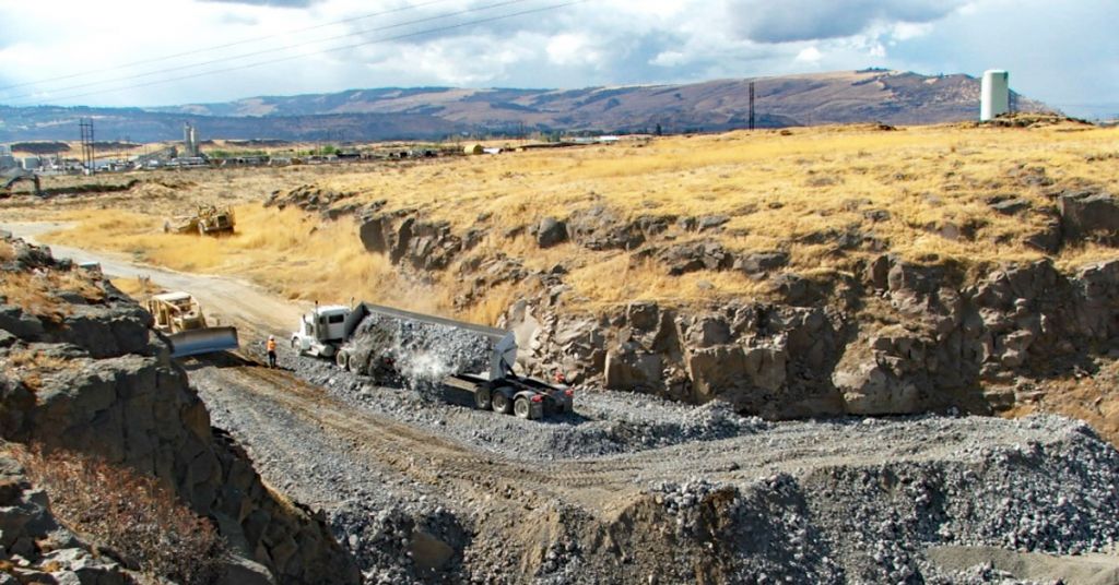
Buried legacy: From 2007-2010, the Wash. Dept. of Ecology and U.S. EPA removed over 135,000 tons of waste from the RAMCO aluminum site. The Port of Klickitat filled the excavation site. The site was removed from the Hazardous Sites List in 2016. Photo by Wash. Dept. of Ecology

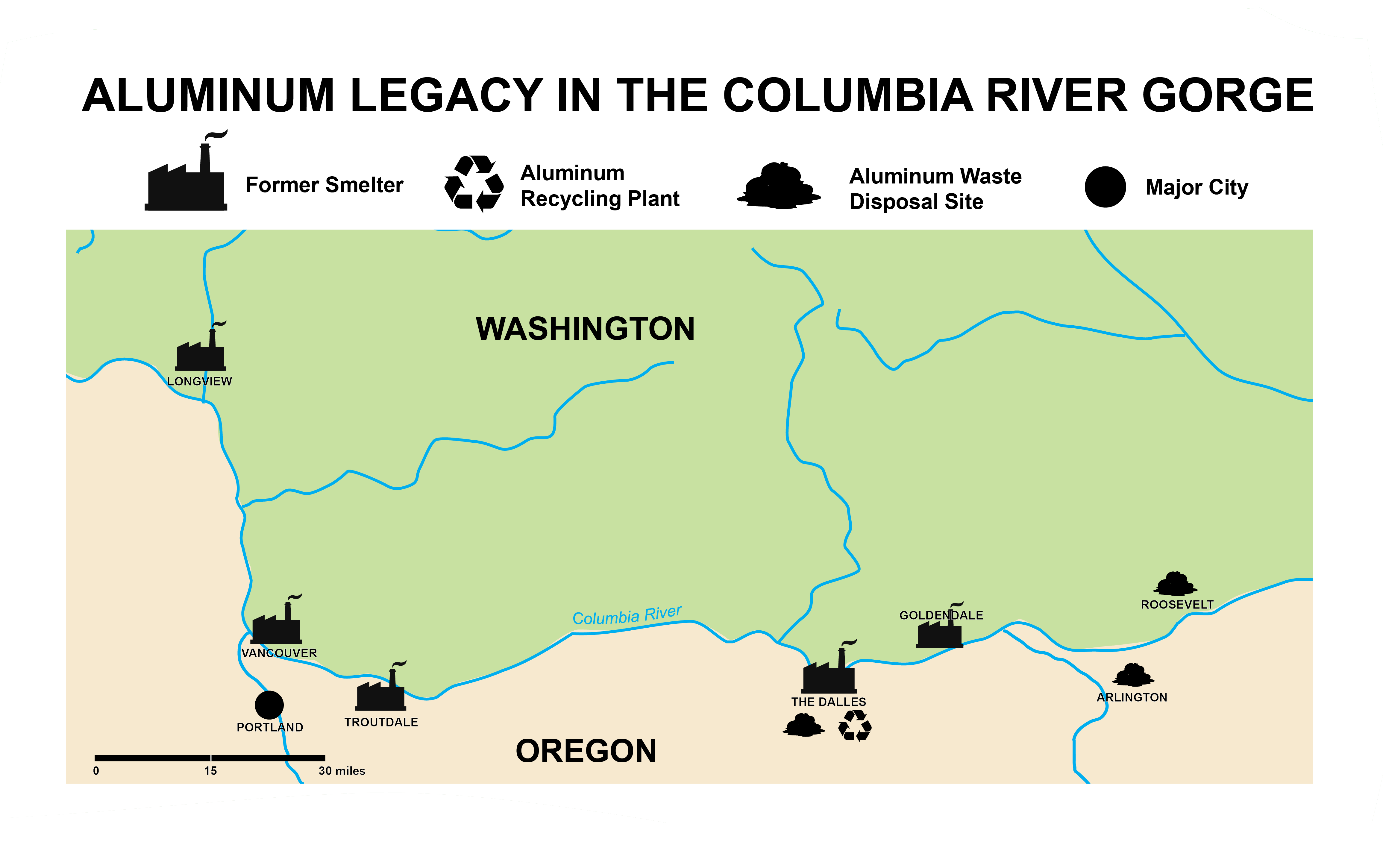
By Valerie Brown. June 10, 2021. In the Columbia River Gorge thousands of tons of aluminum waste is stored in municipal solid waste landfills not intended for this purpose. The waste comes from numerous, long-closed smelters on both sides of the river that were once mainstays of the region’s economy.

But the waste isn’t simply a static relic of a bygone time. Even when stored underground, aluminum waste poses public risks, principally from unwanted chemical reactions, fires and explosions. In the Columbia River Gorge, these may increase when the aluminum recycling industry returns to full post-pandemic activity.

4-PART SERIES: Aluminum in the Columbia Gorge

The story of how the waste got to the landfills dates to the late 1970s.

Records regarding the remediation of the Recycled Aluminum Metals Company (RAMCO) site at Dallesport, Washington, provide a detailed account of a significant portion of smelter waste’s ultimate fate in the region. Its history can be tracked through the published chronology of decisions made by the Port of Klickitat Commission from 1979 through 2006.

In preparing this report the author examined dozens of documents from the Environmental Protection Agency, Washington Department of Ecology, Oregon Department of Environmental Quality, Port of Klickitat and other sources. Records regarding remediation of the Recycled Aluminum Metals Company (RAMCO) site at Dallesport, Washington, provide a detailed account of a significant portion of smelter waste’s ultimate fate in the region. This history is traced through the Port of Klickitat Commission’s chronology of decisions 1979-2006. No government agency or private business responded to requests from Columbia Insight for interviews or comment for this report.
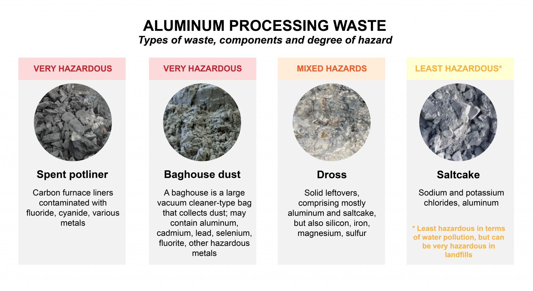
RAMCO waste

In 1979, RAMCO (originally named R.A. Barnes Company) leased space at the Dallesport Industrial Park, which is owned by the Port of Klickitat. The company extracted residual aluminum from wastes produced by smelters in Goldendale, Washington, and The Dalles, Oregon.

RAMCO skirted environmental responsibility from its inception. For example, in a 1979 modification of its original contract with the Port, RAMCO proposed building an addition to its plant “dedicated to inside storage of byproduct ‘to eliminate the need for a waste discharge permit,’” according to a chronology of the Port’s decisions. (The Port’s documents universally refer to the waste left after RAMCO’s reprocessing as a “byproduct.”)

Site of the former Reynolds/Alcoa Superfund site in Troutdale, OR

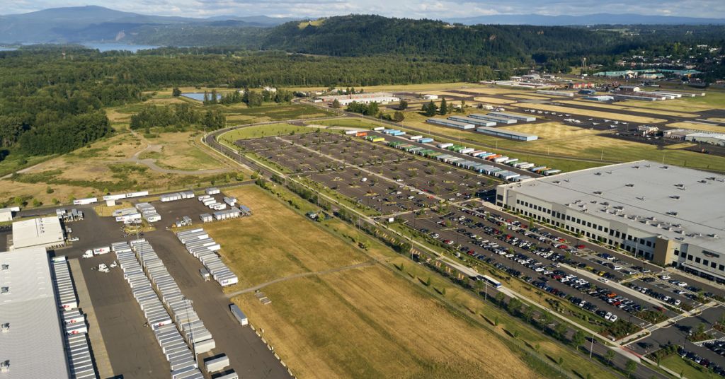
Developing story: About 75 miles west of Dallesport and the RAMCO site, the former Reynolds/Alcoa factory and later Superfund site in Troutdale, Oregon, has been transformed into an industrial jobs center and natural wetland area. The site is now occupied by a FedEx Ground distribution hub (left), Amazon Distribution Center (right) and Troutdale Airport (top right). Photo by NASHCO

It wasn’t long, however, before RAMCO turned a shallow depression on Port property into an unlined landfill. This ad hoc landfill was located a few hundred feet west of Spearfish and Joe’s Lakes, traditional fishing sites used by Indigenous communities for millennia.

According to Port records, both the Port and RAMCO relied on a 1981 opinion issued by the Southwest Washington Health District that “the material from the Barnes Plant [RAMCO] is non-hazardous and land-fillable.” This was a curious justification for the waste disposal given that Health Districts are not the appropriate governing regulatory agency—landfills are regulated by the state and the EPA.

MORE: Dumps, dross and dust: Tracking aluminum waste in the Gorge

In addition, according to a 2006 Washington Department of Ecology cleanup report, an early engineering study concluded that the basalt layer underlying RAMCO’s landfill was solid and would not allow the waste to reach groundwater. Ecology also noted the waste had passed an acute fish toxicity test early on.

It reviewed other tests suggesting the waste was not reactive—that is, it was unlikely to produce chemical processes that could cause trouble. This despite the fact that aluminum is well known to be extremely reactive with numerous other elements.

Turbulent partnership

The Port had initially been attracted by RAMCO’s promise of 40 jobs and the possibility of “a worth in excess of a million dollars.” But its chronology shows RAMCO had management and financial difficulties almost immediately.

By 1982, RAMCO was withholding its rent to the Port in a conflict over an electrical fire. The next year it sued the Port over an insurance dispute. A year later it demanded a new waste disposal site at the Port.

In 1989, RAMCO started sending waste to the Wasco County Landfill (WCL) in The Dalles, but in May 1990 it complained to the Port that the WCL’s fee of $20,000 a month was “making their business operation financially unsound.”

Wasco County Landfill photo by Jurgen Hess

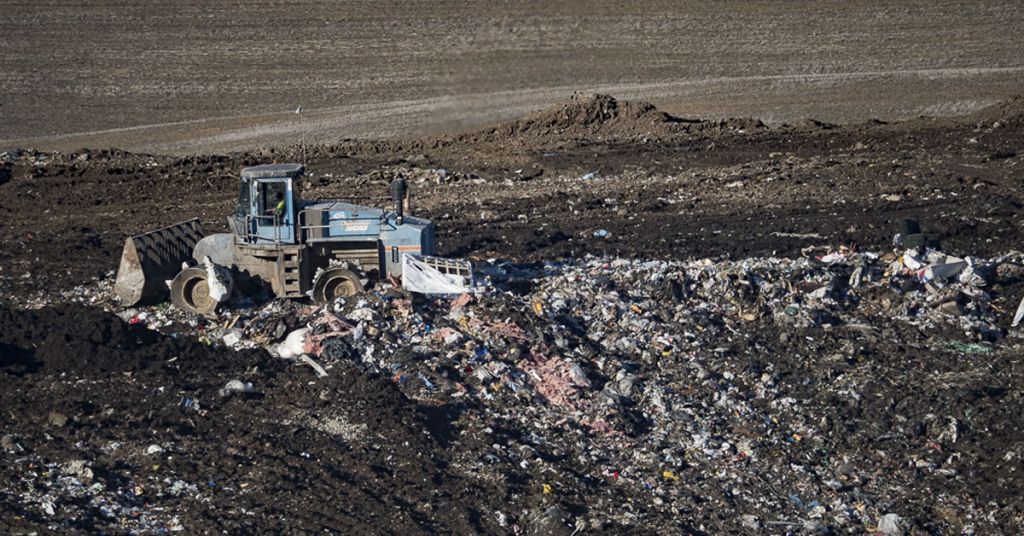
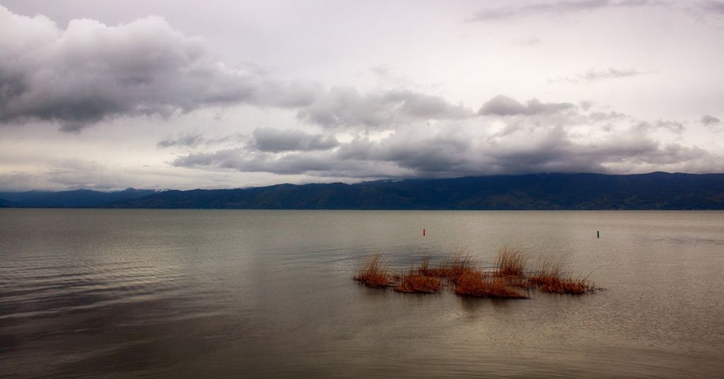
Out of the way: With Mt. Adams visible in the distance, the Wasco County Landfill near The Dalles, Oregon, stores aluminum waste. Photo by Jurgen Hess

The Port responded by instructing its engineer to find a place on Port property for the waste. This spot turned out to be next to the RAMCO building, where a pile of waste soon developed.

The pile drew Ecology’s attention. The Port defended RAMCO when Ecology alleged the company was dumping waste without a permit. By 1991, RAMCO wanted Ecology to remove the classification of its waste as “dangerous.”

This did not happen immediately.

According to a 2011 EPA cleanup contractor’s report, in 1993 RAMCO had tested salt cake, which comprised the majority of its waste, and found it met the state’s definition of “dangerous,” as the salt cake was an aquatic toxin. This finding conflicted with the prior fish toxicity test as well as the Southwest Washington Health District opinion from 1981. The finding came after an unknown amount of waste had been sent to the WCL between 1989 and 1991.

Waste removal

Ecology initially considered the waste problematic, but later changed its position. After RAMCO went out of business in 1994, Ecology agreed to allow transport of the open waste pile next to RAMCO’s building either to the Roosevelt Regional Landfill upriver in Washington or the Columbia Ridge Landfill near Arlington, Oregon.

Approval depended on the waste being crushed and dried, which Ecology decided would reduce its potential for problems in a landfill; Ecology would then remove the state’s “dangerous” classification.

By 1995, about 21,433 tons of the waste had been sent to Roosevelt. Ecology judged that Roosevelt’s “gas and leachate collection systems and liner could adequately deal with disposal of the open stockpile of salt cake from RAMCO.” (Columbia Insight’s investigation found no record showing the Wasco County Landfill could handle such waste prior to its 1989-91 acceptance of RAMCO waste, or during Ecology’s mitigation efforts in the mid-1990s.)

Although Ecology had removed the waste pile next to RAMCO’s building, little had been done about the waste in RAMCO’s unlined Dallesport landfill. In 2005, Ecology reevaluated it, drilling boreholes and testing wells. These efforts produced reports of a “strong odor of ammonia” and high temperature groundwater—indicating chemical reactions occurring below the surface.

Other tests showed that nitrates and salts exceeded water quality standards in groundwater at the site, and that cyanide, chromium and other substances exceeded the EPA’s maximum contaminant level and could leach from the soil.

[perfectpullquote align=”full” bordertop=”false” cite=”” link=”” color=”” class=”” size=””]For most of the public, aluminum waste is now “out of sight, out of mind.”[/perfectpullquote]

Ecology assigned the RAMCO site a hazard ranking of two on a scale of five, with one being the most hazardous. The agency began a cleanup in 2007 and approved sending most of the waste—principally salt cake—to the Wasco County Landfill.

By 2009, it had supervised removal of about two-thirds of the RAMCO waste. But funds from RAMCO and Ecology were inadequate to complete the task.

The EPA then took over. It designated the problem as urgent and completed remediation in 2010. The EPA sent a $2.1 million bill to the Port of Klickitat. Litigation ensued. In a 2015 consent decree, the Port agreed to pay the EPA $2 million.

Risk of fires, explosions

Concerns about waste vary depending on whether it’s in situ and un-remediated or removed and sequestered from the general environment. Regulations regarding disposal of aluminum waste are confusing.

The U.S. government and Oregon DEQ use the term “hazardous,” while Washington uses “dangerous.”

The EPA’s criteria for determining hazard in landfills are ignitability, corrosivity, reactivity and toxicity.

The agency has never ruled that aluminum waste is hazardous, despite the metal’s propensity to react and ignite in some circumstances. Thus it’s not actually illegal to dispose of aluminum processing waste in a municipal solid waste landfill, even though the EPA has expressed mounting concern about the practice.

The main environmental concern regarding the waste while it was at the Port was risk to surface water, groundwater and soil from cyanide, chromium, nitrates and salts. But landfills present more complex hazards. Managers are required to monitor not only landfill leachate—fluids that trickle through the waste and collect at the bottom above the liner—but also the numerous gases that are generated as the waste decomposes both with the help of microorganisms and through abiotic processes.

In addition, aluminum waste may undergo unanticipated chemical reactions with the myriad kinds of trash it encounters in municipal solid waste facilities. The DEQ required the WCL to store aluminum waste separately from general waste and keep it away from the leachate.

When the EPA took over the remediation project it decided, with Ecology’s agreement, to separate the remaining waste into gradations of hazard and dispose of each category differently.

Wasco County landfill, Oregon, by Jurgen Hess

Going underground: The Wasco County Landfill is located approximately six miles south of Interstate 84 using exit 87. Photo by Jurgen Hess

To make the salt cake and dross less problematic, the EPA approved a plan to break the waste up into smallish chunks, spread it out and let it “aerate” for a period of time before it went to the WCL. This would reduce—but not entirely eliminate—the risk of water-aluminum reactions, generation of ammonia and other gases, and therefore the risk of fire and explosion.

Salt cake is the least hazardous of aluminum waste types. But it can contain plenty of aluminum. Ecology found RAMCO’s salt cake contained about 28% aluminum.

MORE: Pollution from aluminum still an issue in The Dalles

Aluminum can “self-heat” and explode in contact with water. Landfills are usually hotter than the surrounding landscape because decomposition produces heat. A warm environment can trigger further chemical reactions involving aluminum. These may produce acetylene, ammonia, hydrogen and methane. Thus aluminum may cause fires in landfills that can’t be extinguished with water.

About 19,000 tons of salt cake and possibly other material labeled “non-hazardous dross material” went to the WCL under EPA supervision. An additional 24 tons was sent to an aluminum recycler for further recovery of the metal. About 16 tons of very hazardous waste went to Chemical Waste Management of the Northwest near Arlington, the only hazardous waste landfill in Oregon.

Legal but problematic

The total amount of aluminum waste remaining in landfills and on closed smelter sites in the Columbia River Basin is unknown. Available documents don’t address the amount, composition and disposition of the tons of waste sent to the WCL by RAMCO from 1989 to 1991. According to Ecology, by the time remediation actions were complete, about 135,000 tons of material had been removed.

As far as Columbia Insight’s investigation can determine, approximately 49,000 tons of that waste is in the WCL.

In 2009, the WCL also accepted about 5,300 tons of waste from the Goldendale smelter as it was being demolished.

A family walks on a path next to the Sandy River in Troutdale, OR that connects to the 40-Mile Loop Trail that is part of the Troutdale Reynolds Industrial Park.

New memories: On the 700-acre former Reynolds Metal Superfund site, the 40-Mile Loop Trail at the Troutdale Reynolds Industrial Park is part of a Port of Portland reclamation effort. Photo by NASHCO

Although it’s not illegal to dispose of aluminum waste in municipal solid waste landfills, the Oregon DEQ requires a special permit to do so. But the WCL did not have that permit when it accepted both aluminum waste and an unrelated toxic, flammable industrial waste in the 2000s. The WCL experienced two fires in 2006.

Ignitability is one of the waste characteristics landfills are required to manage carefully under the federal Resource Recovery and Conservation Act. Municipal solid waste landfill fires in the United States are relatively common, averaging 839 annually, and secondary aluminum processing waste is increasingly considered “a potential source of landfill fire” by experts.

The EPA estimates that nationally nearly 3 million tons of aluminum waste was landfilled in 2018. Given the rapid growth of aluminum use, much more waste is likely to be produced in the future as more aluminum is recycled. It has to go somewhere. MSW landfills are probably not the right place.

MORE: Aluminum’s legacy continues to hang over the Gorge

Public documents regarding the two fires in 2006 at the WCL present radically different explanations of the blazes.

WCL told the DEQ in a September 6, 2006, report that the first fire, on August 22, was caused by a “hot load”—that is, it was already burning when it arrived at the landfill—and was extinguished with water. This explanation was repeated in a March 7, 2007, fire risk assessment conducted on behalf of Waste Connections, the parent company of the WCL.

As for the second fire, the WCL told DEQ it occurred in the early hours of September 4 and was extinguished with water by 2 a.m.

A DEQ inspector visited the WCL the day after the second fire and accepted management’s explanation of the cause.

Aluminum scrap at Hyrdo Extrusion facility in The Dalles, Oregon by Jurgen Hess

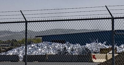
Remnant: Aluminum scrap at the present-day Hyrdo Extrusion facility in The Dalles awaits recycling. Photo by Jurgen Hess

However, the fire consultant’s report six months later said the fire took all day to control and was extinguished with soil rather than water. The consultant had talked to landfill workers, who believed the fire occurred because water had contacted a material the landfill was illegally receiving—anhydrous magnesium chloride.

The consultant concluded that a “combination of events resulted in a ‘Perfect Storm’ scenario that ultimately resulted in fires.” The fires’ connection with anhydrous magnesium chloride did not become known to the DEQ or the public until significantly later.

Between 2000 and 2008, the Wasco County Landfill took in 7,900 tons of anhydrous magnesium chloride waste from production of titanium and zirconium at Oregon Metallurgical in Albany and TDY Industries in Millersburg. Magnesium chloride, like aluminum, is likely to explode when it encounters water. The WCL was one of four Oregon landfills that took in a total of 160 million tons of anhydrous magnesium chloride from the Willamette Valley companies.

In 2014, the EPA fined the Willamette Valley companies a total of $825,000 for illegal dumping of the material. The WCL pleaded ignorance and was not cited.

Waste Connections Vice President John Rodgers told Columbia Gorge News the magnesium material was not “deemed or designated by any agency as hazardous” and the landfill stopped accepting it as soon as it learned otherwise.

The WCL hasn’t responded to Columbia Insight’s queries for information and comment.

A kayaker near the mouth of the Sandy River, to the right is the Sandy River Delta. June 7, 2021

Unseen history: The Sandy River Delta is a popular recreation area. In the 1950s and ’60s, area farmers filed several lawsuits against Reynolds Metals saying they were poisoned by toxins spewed out by the company’s aluminum operations in Troutdale. Photo by NASHCO

The period when WCL accepted anhydrous magnesium chloride overlapped with about a year of its acceptance of aluminum waste. Despite the fact that the DEQ is the controlling agency for Oregon landfills, the EPA, the Washington Department of Ecology and various contractors worked out procedures with WCL to transfer RAMCO waste—nobody informed the DEQ of the transfer. In fact, the agency didn’t know about either the RAMCO waste or the anhydrous magnesium chloride waste until 2009.

When the DEQ did learn of the illegal disposal, the agency asked WCL to provide “a copy of the Department-approved special waste management plan for accepting and disposing of hazardous substance contaminated waste” from RAMCO. It discovered there wasn’t one.

The agency expressed concerns about “self-heating and ammonia-generating properties” of the RAMCO waste if it contacted water. It also observed the overlap in time with the landfill’s acceptance of anhydrous magnesium chloride. The landfill’s role in the latter violation wasn’t resolved until 2014.

Lingering issues

The legacy of aluminum processing in the mid-Columbia River Basin extends far beyond the factories themselves. It will last lifetimes.

It took almost 30 years to clean up the waste from two smelters and a reprocessing plant, during which time communications and actions by a private landfill company and state and federal regulatory agencies were less than straightforward.

For most of the public, aluminum waste is now “out of sight, out of mind.” But it still poses hazards ranging from groundwater contamination to fires and explosions.

Problems at municipal solid waste landfills may re-emerge unless the EPA resolves its policy contradictions to require disposal in different facilities. So far the waste products of the long-gone aluminum industry in the Columbia River Gorge haven’t produced widespread environmental or health disasters, but it’s clear from the historical record that this state of affairs is as much due to luck as it is to wise decision-making and safe disposal practices.

READ THE FULL 4-PART SERIES: Aluminum in the Columbia Gorge

Infographics by Mackenzie Miller. 

SEJ logo with urlColumbia Insight‘s series focusing on the aluminum industry in the Columbia River Gorge is supported by a grant from the Society of Environmental Journalists.


By |2023-11-06T14:07:11-08:0006/10/2021|Aluminum|4 Comments

Umatilla Tribes lead the way in reacquisition of treaty lands

After deciding the U.S. government was never going to live up to its obligations, a pro-active plan to buy back its lands has brought the Umatilla Tribes national recognition

Girls in Umatilla beaded regalia of them looking west. Photo by Walters Photographers

Forward view: Traditional Umatilla lands are gradually reverting to tribal control to benefit future generations, such as these girls in beaded regalia. Photo by Walters Photographers

By Wil Phinney. May 27, 2021. Thirty-two years ago, when the Umatilla Tribes realized non-Indians owned more property on the 172,000-acre reservation than the combined total for tribal government and tribal allottees, it embarked on a 50-year plan to buy back its land.

Thanks to an aggressive Land Acquisition Program, today the Tribes own 94,590 acres. Since 1990, the Tribes have purchased 77,346 acres—43,393 acres in fee status and 33,953 acres in trust status.

“After the 1855 Treaty, the Tribe’s homeland was reduced considerably,” says Bill Tovey, director of the Confederated Tribes’ Department of Economic and Community Development. “The Tribe figured the federal government would not live up to or solve the problems they created, so we developed our plan to buy back our homeland.”

About 24,000 acres of the 70,000 the Tribes have purchased are within the Tribes’ ceded territory but lie outside the reservation. That includes Rainwater, an 11,000-acre wildlife reserve near Dayton, Washington. It’s filled with mountain timber and is home to big game like deer and elk.

Umatilla lands map

TRADITIONAL USE BY THE CAYUSE, UMATILLA, WALLA WALLA TRIBES

The Wanaket Wildlife Area preserve, about 2,700 acres some 60 miles north of the reservation near the Columbia River, is open for waterfowl hunting. The Wanaket property also includes 190 acres near the Port of Umatilla zoned for industrial use.

Another seven off-reservation parcels range in size from 45 acres to 666 acres. On-reservation, the 5,000-acre Wheelhouse property purchased last year, which the Tribes hope will become a popular area for hunting and gathering, includes steep, rocky ravines with some livestock grazing at the south end of the reservation.

The Tribes have also purchased several parcels on all four corners of Exit 216 on Interstate 84 for economic development. 

MORE: Under pressure: The Oregon community desperate for water

“We figured out that if we wanted sovereignty, we have to have ownership,” says Tovey. “We had some regulatory authority, but better than regulatory is ownership.”

It’s a great story, but it’s one that started long before the 2020s or even before 1989 when the Tribes’ Land Acquisition Program started.

Creating the ‘checkerboard’

In 1855, the Umatilla, Cayuse, and Walla Walla Indians—the Confederated Tribes of the Umatilla Indian Reservation (CTUIR)—ceded some 6.4-million acres to the United States government with the promise of a 520,000-acre homeland in eastern Oregon.

Umatilla Tribes photo

Ground gamer: Bill Tovey, director of the Confederated Tribes’ Department of Economic and Community Development. Photo by Umatilla Tribes

A subsequent government survey reduced the reservation by almost half to 265,000 acres.

The Slater Act of 1885, specific to Oregon, and the General Allotment Act of 1887, reduced the reservation again to 172,000 acres.

In addition to making the reservation smaller, these two acts also led to the land, which had previously been used communally, being split up into individual allotments.

The U.S. government gave CTUIR males 160 acres, women 80 acres and children 40 acres. The rest was considered “excess” and sold to the white immigrants coming west, creating a checkerboard of Indian and non-Indian ownership across the reservation.

MORE: Opinion: Why the Gorge pumped-hydro project is opposed by the Yakama Nation

Indian-owned land has been divided into two types: fee and trust.

Tribal trust lands are held in trust by the United States government for the use of a tribe. The United States holds the legal title, and the tribe holds the beneficial interest. This is the largest category of Indian land. Tribal trust land is held communally by the tribe and is managed by the tribal government.

Fee land is reservation land no longer in trust or subject to restriction. Sometimes a tribe, or individual tribal members, has land in fee. The term refers to the “fee patent” document issued to the individual Indian landowner.

The allotment system further diminished the amount of Indian-owned land when allottees sold their parcels, which were often too small to earn a living from and too large to maintain.

[perfectpullquote align=”full” bordertop=”false” cite=”” link=”” color=”” class=”” size=””]“I’d put them in the top five tribes in the country for regaining lands.” — Cris Stainbrook, Indian Land Tenure Foundation[/perfectpullquote]

In 1920, Poker Jim, a headman for the Walla Walla Tribe, in a statement published in the East Oregonian newspaper, explained why the Walla Wallas were sending a delegate—his son—to Washington, D.C., to speak with Cato Sells, the commissioner of Indian Affairs from 1913-1921, about the allotment deal.

“We do not want these allotments and do not want patents [government grant] here,” proclaimed Poker Jim. “The game and fish is pretty nearly all gone from this country now and if you let the Indians get patents and sell off their lands pretty soon there will be no more home for the Indians here.”

Poker Jim’s statement appealed to Sells to help educate young men who, as soon as they got their allotment, would “sell their land and then they do not have any land and do not have any money because the money is soon spent and drawn, and the Indians are left without any home or any land to live on. Pretty soon, if you let them go on this way, the old Indians will be dead, and the young Indians will be beggars, because they will waste their land and money if they get patents.”

Despite Poker Jim’s request, non-Indians were allowed to purchase lands across the reservation.

Umatilla innovation

A strategy meeting in 1989 included representatives from the CTUIR, the Bureau of Indian Affairs and land experts like Cris Stainbrook, who is now president of the Indian Land Tenure Foundation headquartered in St. Paul, Minnesota.

Dave Tovey (Bill Tovey’s brother), a CTUIR planner at the time, wrote a 50-year plan that envisioned the Tribes directly owning or managing 40% of the reservation land by the year 2040. That’s a little over 100,000 acres of the land within the original 265,000-acre treaty boundaries—about six times more acreage than the CTUIR owned in 1990.

Girls in Umatilla beaded regalia facing north looking at the foothills of the Blue Mountains and ridges above the Walawála Valley (Buckaroo Creek) on Umatilla Reservation.

More out there: Blue Mountains above the Walawála Valley (Buckaroo Creek) on the Umatilla Reservation. Photo by Walters Photographers

Stainbrook was working at the time with First Nations Development Institute, a nonprofit organization that assists Native American communities in economic development, when he met with CTUIR leaders. He’s watched the Tribes grow over the last three decades.

“I was always impressed with Umatilla,” says Stainbrook. “Over the years I’ve been watching the progress. When the Tovey boys showed up things started to move.” Dave is now the director of Nixyaawii Community Financial Services; Bill is the director of the CTUIR Department of Economic and Community Development; and Al manages Wildhorse Casino.

“Over the years I’d put them in the top five tribes in the country for aggressively regaining lands as well as using the land for tribal economic development.”

Getting fair market value

In the mid-‘90s the CTUIR created its land-acquisition program. It initially purchased land using money from mitigation funding to Tribes for the loss of land, including wildlife habitat, caused by dams on the Columbia River, and the Bonneville Power Administration for salmon recovery. A percent of gaming revenues from Wildhorse Resort & Casino as well as bank financing and contract sales has also been dedicated for land purchases.

Of the Tribes’ 43,393 acres of fee property purchases, 21,688 acres were paid for with mitigation funding and 21,705 acres using Tribal money.

Blue Mountain foothills above the CTUIR's major crop, wheat.

Integrated planning: Blue Mountain foothills rise above the Confederated Tribes’ major crop: wheat. Photo by Walters Photographers

Bob Burns, an accredited rural appraiser, has been working for more than 50 years as a farm and ranch appraiser. He’s worked with the CTUIR staff in the Land Acquisition Program for several years.

“They know what they’re doing and if they don’t they ask direct questions of the right people,” says Burns.

Burns notes that the Tribes try to purchase land at fair market value but are often faced with a higher asking price.

“A lot of people take a run at them with a price that’s way too high. They think because the Tribe has a casino they can ask a premium,” Burns says. But staff in the Land Acquisition Program “talk to people one on one and it usually comes down to the price of the appraisal; the real fair market value is what the Tribes do.”

Funding the buy-back

The Land Buy-Back Program was created as a result of the settlement in Cobell v. Salazar. In the late 1990s, Elouise Cobell, a Blackfeet Indian from Montana, sued the Bureau of Indian Affairs for 100 years of inadequate accounting of compensation owed Indians for leases.

The trial lasted a dozen years and Cobell died before she could see the creation of the Land Buy-Back Program, which is funded by a settlement of $3.4 billion.

A total of $1.5 billion is being distributed to current Tribal-member landowners based on the value of the property and income that could have been produced over the last century.

I-84 cuts through Umatilla Reservation lands

Historic division: I-84 cuts through Umatilla Reservation lands. Photo by Maryellen McFadden/Creative Commons

Funded by the other $1.9 billion in the settlement, the Buy-Back Program set aside funding for tribes throughout Indian Country to reduce fractionation—that is, land that through inheritance is often owned by hundreds of Indians, many from different reservations.

The Umatilla Tribes received about $20 million in two allocations as their share of the $1.9 billion but expect to get more, according to Bill Tovey. This has helped the Tribe purchase almost 13,000 highly fractionated acres of land within the Reservation.

To address fractionation, in 2008 the Umatilla Tribes updated their inheritance code, which now requires that when a landowner dies their land can only be passed to CTUIR members. Each year the Tribes spend around $700,000 on land in program that has no CTUIR heirs. Purchasing that property is no easy task. In some cases, hundreds of owners—many from other Northwest reservations—share in small parcels.

Tovey knew of one parcel of slightly more than a third of an acre owned by more than 20 Indians. In those instances, the CTUIR has issued checks for pennies, especially if the parcel is rangeland, which is valued lower than productive farmland.

MORE: Environmental justice at Hanford: Reconnecting Indigenous people to their land

Of the 33,953 acres of Trust land purchases, the Tribe has bought 15,788 acres from willing sellers, 5,495 acres through probate and 12,670 acres with the Land Buy-Back Program.

Tovey says the CTUIR is well on its way to realizing the land acquisition vision set out by his brother in 1990.

“The CTUIR has been very aggressive with land acquisition,” Tovey says. “The staff has grown from one in 1990 to 10 people who work on acquisitions, probates, fee to trust, land management and data collection. Gaming revenues and mitigation funds have helped push the ball further with the Land Buy-Back Program giving the Tribe big bursts of funding to secure lands.”

Wil Phinney recently retired after 24 years as editor of the Confederated Umatilla Journal, the award-winning monthly newspaper on the Umatilla Indian Reservation in eastern Oregon. He lives in Pendleton, Oregon.

Pat and Ric Walters have owned and operated Walters Photographers, a portrait studio in Pendleton, Oregon, for 30 years. Pat is a member of the Confederated Tribes of the Umatilla Indian Reservation and enjoys photographing the people and land of the CTUIR. 

READ MORE INDIGENOUS ISSUES STORIES.

The Collins Foundation logo

The Collins Foundation is a supporter of Columbia Insight’s Indigenous Issues series.

By |2023-05-02T15:04:04-07:0005/27/2021|Indigenous Issues|4 Comments

Toxic cyanobacteria choke water systems around California’s Clear Lake

INN Tapped Out logo reversed

This story is part of Tapped Out, a series of stories about power, justice and water in the West. You can access the entire series at the Institute for Nonprofit News.

Toxic blooms are a public health risk and increase water treatment costs

California’s Clear Lake in a better time. Photo Brett Walton/Circle of Blue

By Brett Walton, Circle of Blue, May 7, 2021. On a good day, usually in late winter and early spring, the magnificent waters of Clear Lake seem to live up to their name. Under the shadow of the volcano Mount Konocti, the oldest lake in North America and second largest in California sparkles in an array of blues while fishing boats ply the shallow nearshore, their anglers hoping to hook a trophy bass.

From his office two miles inland, Frank Costner knows that the lake’s waters also shelter a treacherous occupant—potentially toxic blooms of cyanobacteria. As general manager of Konocti County Water District, Costner is responsible for supplying drinking water from Clear Lake to 4,500 people who live in this region a two-hour drive north of San Francisco.

Costner has worked at the district for 32 years and he knows when lake conditions deteriorate. Mats of cyanobacteria ring Clear Lake during warm months, covering its crystal waters along the shoreline with paint-like swirls of green and white.

When the wind comes from the west, foul odors waft toward his office.

“Kind of like dog poop,” Costner told Circle of Blue. “It’s pretty rough.” He searched for the right adjectives. “Poopy? I don’t know. Not like feces, per se—like human feces—but definitely like a dog poop smell. Decaying matter? It does smell bad.”

Not only an aesthetic affront, the harmful algal blooms are a threat to public health, recreation, and the local economy. For the 18 public water systems that draw from the lake the noxious blooms are something else: an operating hazard that is complicating their treatment processes and increasing the cost of providing clean water in one of the state’s poorest counties. For more than three decades, Costner has had a front-row seat.

“I’ve just seen the continual decrease in water quality, getting worse and worse as the years go by,” Costner said, reflecting on his career. “Water treatment is becoming harder and harder.”

Seeking better water

The degradation of Clear Lake and the steps Costner and other water managers are taking to deal with it, are a distillation of the turmoil that algae and cyanobacteria are taking across the United States and around the world. Climate change and nutrients flowing from the land are the primary ingredients of a toxic soup that is endangering lakes and rivers, and challenging public health and economies from California to China, from South Africa to France.

Because of the harmful algal blooms “water treatment is becoming harder and harder,” says Frank Costner, general manager of Konocti County Water District, which supplies drinking water to about 4,500 people. Photo Brett Walton/Circle of Blue

Reducing the threat, as Costner has learned, is expensive. State and federal water quality regulators, prodded by deteriorating conditions at Clear Lake and in other areas, are taking notice.

It all starts with cyanobacteria, sometimes called blue-green algae, ancient single-celled organisms that thrive in warm, nutrient-rich waters. Sometimes they produce toxins. For swimmers, the toxins can cause skin rashes and allergic reactions. Depending on which of the dozens of cyanobacteria species is present, consuming the toxins can lead to intestinal infections, liver damage, or nervous system impairments. Dogs have died from drinking toxin-laced water.

Front of mind for drinking water providers and regulators are recent contamination events that shook U.S. cities from coast to coast. Cyanotoxins from a harmful algal bloom in Lake Erie infiltrated Toledo’s drinking water system in 2014, leading city officials to warn more than 400,000 people not to use their tap water for days.

In 2018, residents of Salem, Oregon, found themselves in the same scenario when cyanobacteria proliferated in Detroit Reservoir and wound up in the city’s distribution system.

The conditions prevalent in Lake Erie’s western basin are also present in shallow Clear Lake, where lakebed sediments are fortified with centuries of accumulated phosphorus. A host of other sources around the lake—septic tanks, stormwater drainage, farm runoff, land erosion—add more phosphorus as well as nitrogen to the mix.

Though acute cases of cyanotoxin poisoning in humans are rare, the last thing Costner wants is a crisis similar to Toledo or Salem to unfold for his customers. Fortunately his protections against such an event will soon be strengthened.

His district broke ground in March on a near-total system overhaul, a $10 million renovation funded in full by a state grant because the district is classified as a severely disadvantaged community.

The project is expansive. A new water intake will extend 1,500 feet into the lake, nearly four times longer than the current pipe, in hopes of accessing water farther away from the blooms that cluster along the shore. The longer intake will ease the strain on the district’s pumps when the lake is low.

Because electric utilities in fire-prone California are now preemptively shutting off power on dry, windy days to reduce the odds that their transmission lines spark a wildfire, the district will be getting a backup generator, too. A power shutoff in Lake County in 2019 lasted four days, and Costner was able to run his aging generators only 14 hours a day before they needed a break.

Also in the grant package: a new pump house, a raw water line to the treatment plant, a charcoal and sand filter that doubles the filter capacity, a clear well where treated water is stored, and an upgraded computer control system.

The entire project is a response to the severe drought year of 2014, when lake levels plunged and the cyanobacteria grew from a nuisance to a threat, a situation that is poised to reemerge in the months ahead. California just experienced its third driest winter on record.

Clear Lake is near the lows from 2014. So Costner is bracing for another grueling warm season.

“It’s going to be a really, really bad summer,” Costner said. “Let’s just hope it doesn’t get as hot as it’s been.”

Costner said that in March. As the calendar turns to May, and with Gov. Gavin Newsom having declared drought emergencies in the counties to the south and west of Lake County, a bad algae year on Clear Lake seems all the more likely.

California’s Clear Lake is located northeast of San Francisco. 

Systems under strain

The central geographic feature of Lake County, Clear Lake is the drinking water source for two-thirds of its 65,000 residents. Like Costner’s district, these are mainly small systems that serve a few thousand people.

The lake itself is a marvel, formed more than 2 million years ago at the intersection of three geologic fault lines. Indigenous groups have lived along its fertile shores for some 12,000 years.

It’s also a degraded environment, not only from the harmful algal blooms and loss of 85 percent of its wetlands but also from a history of mercury mining that began just after the Civil War and lasted until 1957.

Clear Lake’s irregular shoreline is dimpled with bays and inlets. Add in shifting wind patterns due to the bulk of Mount Konocti and three distinct sub-basins, and you get a lake whose water and nutrient movements are highly variable, says Alexander Forrest of the University of California, Davis.

Forrest is part of a state-funded research project that is mapping the lake’s water and nutrient flows in order to forecast blooms and, possibly, design interventions to prevent them.

Signs warning of the dangers of cyanotoxins are posted at public parks around Clear Lake. Photo Brett Walton/Circle of Blue

The unusual hydrology has a direct effect on the cyanobacteria blooms. They tend to concentrate in the lake’s smaller eastern sub-basins, the Oaks Arm and Lower Arm, which appear from above like the pincers of a crab claw. Because of the clustering, not all water systems around Clear Lake have had the same experience with algae.

Buckingham Park Water District is on a peninsula that juts into the middle of the lake. Ahimsah Wonderwheel, the general manager, told Circle of Blue that the district’s location has protected it from being overwhelmed by blooms.

The district has been voluntarily testing its water for cyanotoxins for three years, but it has not needed to install any new treatment equipment, even though there are no California or federal drinking water standards for cyanotoxins that would require him to do so.

Still, the toxins aren’t the only headache for drinking water operators. The blooms themselves—their soupy biomass—are enough to cause problems.

Scott Harter is the special districts administrator for Lake County, which manages two small treatment facilities that draw from the lake. Harter said that the blooms tax the water treatment system, increasing operating and electrical costs because filters have to be flushed more frequently.

Costner also has seen his operating costs rise. The algae build up in his treatment works, producing more sludge that the district has to discard. Each truck load he sends to the recycling center costs him $250.

Then there are the increased costs of chemicals and labor, plus more frequent filter changes. Carbon filters that used to last five to seven years are now being replaced in half that time. Though Costner could not give an exact figure, the costs add up.

“Whether or not cyanobacteria are producing toxins, just the presence of cyanobacteria themselves can cause all of these issues in treatment processes,” explained Stefan Cajina of the state Division of Drinking Water. “It is a tremendous challenge for these systems. They do have to deal with it out of their own budgets and operations staff. I can tell you that many of these systems have been under a lot of strain to deal with this in the summer and fall months.”

Cyanobacteria blooms on Clear Lake in June 2020 resembled whorls of green and white paint. Photo courtesy of Micah Swann

The harmful algal blooms in Clear Lake have caught the attention of Cajina and other state regulators. Starting this summer, the State Water Resources Control Board is requiring the 18 drinking water providers around the lake to test their treated and untreated water for microcystins, which is one of the cyanotoxin groups. It is the first time the Water Board has issued such an order anywhere in the state.

“We’re doing it in Clear Lake because the magnitude of the problem is so apparent there and well documented,” Cajina told Circle of Blue. “It’s one of the few water bodies in the state where we can say with some certainty that just about every year in the summer and fall months we’re going to see significant levels of microcystins.”

In 2018, the Division of Drinking Water found that all public water systems around Clear Lake had treatment systems that were effective barriers against cyanotoxins, but Cajina said the new order will provide more data than that one-time snapshot.

State officials are not the only ones concerned. The U.S. Environmental Protection Agency published health advisories in 2015 for two cyanotoxins: cylindrospermopsin and microcystins.

Health advisories are unenforceable guidelines that function as a warning signal to water utilities. Below the exposure level, which is measured in days, years, or a lifetime, no health damage is expected to occur. Utilities are not punished if they exceed the advisory as they would be for formal regulations.

To inform potential regulatory standards that utilities would be required to achieve, the EPA ordered more than 3,400 drinking water providers nationwide to look for the toxins.

From 2018 to 2020, these utilities tested their treated water for nine cyanotoxins as well as for total microcystins. Only seven systems reported microcystins levels above the health advisory.

Clear Lake sparkles on a sunny morning in March 2021, showing no evidence of the harmful algal blooms that tend to appear later in the summer. Photo Brett Walton/Circle of Blue

Though few systems had toxins survive the treatment process, the threat still lurks in rivers and lakes. Nutrient levels in waters and soils are already high, and warming temperatures are an added boost to cyanobacteria, says Hans Paerl of the UNC Chapel Hill Institute of Marine Sciences.

“They like global warming,” Paerl, one of the country’s foremost cyanobacteria researchers, told Circle of Blue. “They do better when it’s warmer because their optimal growth temperatures are relatively high. Everything you can think of that we’re currently discussing about climate change pretty much benefits them.”

Costner has witnessed these changes, too. His backyard weather station recorded between 6 and 7 inches of rain last year. Usually the area gets more than 25 inches. Clear Lake is nearly as low today as it was in 2014, when the full force of drought fell upon the state.

Though he is apprehensive about the coming summer, Costner is hopeful that the system renovation, when it is completed in 2023, will provide the district and his customers with better water — his family included.

“I live in my district, I drink my water,” he said. “My grandchildren and my children drink the water. I want to have safe water. I want my community to have safe water.”

Brett Walton writes about agriculture, energy, infrastructure and the politics and economics of water in the United States. He also writes the Federal Water Tap, Circle of Blue’s weekly digest of U.S. government water news. He is the winner of two Society of Environmental Journalists reporting awards.

Tapped Out logo


This piece is part of a collaboration that includes the Institute for Nonprofit News, California Health Report, Center for Collaborative Investigative Journalism, Circle of Blue, Columbia Insight, Ensia, High Country News, New Mexico In Depth and SJV Water. It was made possible by a grant from The Water Desk, with support from Ensia and INN’s Amplify News Project.

By |2021-05-18T08:46:03-07:0005/07/2021|Uncategorized|0 Comments

California tribes call out degradation of Clear Lake

INN Tapped Out logo reversed


This story is part of Tapped Out, a series of stories about power, justice and water in the West. You can access the entire series at the Institute for Nonprofit News.

A monitoring program tracks toxic cyanobacteria and influences change

Clear Lake, California

Formed some 2 million years ago at the intersection of three geologic faults, Clear Lake is a natural marvel, considered the oldest lake in North America. It’s also the site of severe blooms of toxic cyanobacteria from June through November that obscure the water and are a risk to health and safety. Photo Brett Walton/Circle of Blue

By Brett Walton, Circle of Blue, May 7, 2021. Seven years ago, after the fish died, Sarah Ryan decided she couldn’t wait any longer for help.

California at the time was in the depths of its worst drought in the last millennium and its ecosystems were gasping. For Ryan, the fish kill in Clear Lake, the state’s second largest and the centerpiece of Lake County, was the last straw.

Ryan is the environmental director for Big Valley Rancheria, a territory of the Big Valley Band of Pomo Indians that sits on the ancient lake’s western shore. She and others raised alarms for several years about increasingly dire blooms of toxic cyanobacteria. But Lake County officials and state agencies were not gathering the data on toxin levels that Ryan thought was necessary to adequately communicate the health risks to tribe members or to anyone else using Clear Lake to swim, fish, drink — or walk their dog.

A year earlier a dog had died after drinking lake water. Fishing tournaments were cancelled due to the noxious scum, and the lake was starting to smell rotten in the warm months. It was time to act, she thought.

Along with Karola Kennedy, then the environmental director at Elem Indian Colony, another area tribe, Ryan developed a plan. In the summer of 2014 Ryan and Kennedy laid out a map on a table — “our war room,” as Ryan described it — and chose several shoreline sites to collect water samples. They sent the samples to the lab and waited.

The first results came back in early September, well after midnight on a Friday. Ryan was still awake. She looked at the readout on her screen. A sample taken about 100 feet from a drinking water intake showed more than 17,000 micrograms per liter of microcystins, a liver toxin produced by the microcystis species of cyanobacteria. The U.S. Environmental Protection Agency health guideline for microcystins in waters where people swim and boat is 8 micrograms per liter. California suggests posting warnings at beaches when levels reach 0.8 micrograms per liter.

“Oh my gosh,” Ryan recalled thinking. “We have a problem here.”

A lake out of balance

The sample results, and the work Ryan and Kennedy have done to promote and explain the implications for public health and the recreational economy, prompted local and state responses that distinguish Clear Lake as a test bed for understanding and solving a worsening global water pollution challenge.

Neither California nor the federal government regulate cyanotoxins in drinking water.

Clear Lake, California

In summer and fall, mats of toxic cyanobacteria can clog the perimeter of Clear Lake. In this photo from June 2020, a bloom forms in Soda Bay, on the lake’s southern shore. Photo courtesy of Micah Swann

Two-thirds of Lake County’s 65,000 residents are served by utilities that use Clear Lake as a water source. What government officials want is more data. Starting this summer, the State Water Resources Control Board ordered the 18 public water systems that draw from Clear Lake to test their treated and untreated water every two weeks for microcystins. In addition, the Water Board asked the state Office of Environmental Health Hazard Assessment in February to evaluate scientific information on four cyanotoxins and recommend whether the state should establish notification levels, which are health-based thresholds that require utilities to tell customers when the toxins are present.

Sometimes called blue-green algae and a constituent of harmful algal blooms, cyanobacteria are single-celled organisms that turn sunlight into energy. Alive on the planet for more than 2 billion years, they were the first species to produce oxygen as a by-product of respiration. You and I can be thankful for that. But because they’ve endured the eons — outlasting ice ages as well as hothouse conditions — they are adaptable survivors.

“In a way, their playbook is very deep,” Hans Paerl, a professor at the UNC Chapel Hill Institute of Marine Sciences and one of the country’s foremost researchers of cyanobacteria, told Circle of Blue. “Evolution has served them for a long period of time.”

Today, however, a deep playbook is less and less necessary. Humans are making it easier on cyanobacteria. The organisms live everywhere, but they prefer warm, stagnant waters that are saturated with nutrients. As they see it, a planet blanketed by heat-trapping greenhouse gases, loaded with nitrogen and phosphorus, and saturated with slack water and rivers impeded by dams is a cozy and welcoming home.

“Almost every modification we’ve gone through — in terms of creating more nutrients or altering the flow of water in natural systems — seems to benefit their ability to form blooms and proliferate in those blooms,” Paerl explained. The blooms, in other words, are living in a boom time.

Clear Lake, about 100 miles north of San Francisco, is relatively shallow, warm and, by its nature, biologically productive. That’s why it’s known as one of the best bass fishing spots in the country. It’s also considered the oldest lake in North America, which means that algae have probably been present for some portion of its 2 million years. Indigenous groups have lived along the lake’s clean waters and fertile shores for some 12,000 years.

But over the last century and a half, Clear Lake’s ecological balance has come undone. White settlers planted orchards, dug mercury mines, and built homes and towns. In the process an estimated 85 percent of the lake’s nutrient-absorbing wetlands were destroyed.

Ron Montez

An elder of the Big Valley Band of Pomo Indians, Ron Montez, Sr. has spent a lifetime around Clear Lake. The lake is central to the tribe’s culture, he says. Members collect tule reeds around its shores for making baskets and canoes and immerse themselves in the water before dances and ceremonies. Photo Brett Walton/Circle of Blue

Unimpeded flows of nitrogen and phosphorus tipped Clear Lake into hyperproductivity, or eutrophication. Algae and cyanobacteria blooms worsened in the 1970s, started improving through the 1990s, and now are as extensive as any in generations. While the middle of the lake can be scum-free, the blooms paint the nearshore waters in the summer and fall in whorls of green and white. They emit terrible odors, described by various locals as like kimchi, dog poop, baby’s diaper, sewage, and “not as pungent as skunk, but on its way there.”

Ron Montez Sr., an elder of the Big Valley Band of Pomo Indians, has witnessed those changes. He grew up around the lake, but his family had no running water. Instead they used buckets to gather from the lake what they needed at home. If algae were present, they would filter the water by pouring it through a cloth. To bathe, he would jump in the lake. Sometimes he would hold bread in his hands until the fish nibbled.

Montez, who is 71, told Circle of Blue that the lake is central to his cultural identity and for his community’s livelihood. It’s where they collect tule reeds for weaving baskets and making boats, where they caught catfish, hitch, and perch for sustenance and income, where they splished and splashed. The lake is also where tribe members congregate for ceremonies, like the annual Big Head dances held in the spring.

“Before any dance we have to enter into the water, have our heads under the water,” Montez explained. The tribe members dance also for healing if someone is sick. “It’s cleansing before that time [of the dance], which is sacred.”

Montez continued. “The water is very important,” he said. “It’s tied to us spiritually, physically. That has all been reduced because of the algae and other contaminants out there.”

Recognition and response

Sarah Ryan is not indigenous, but she has worked for Big Valley’s environmental department since 2001, becoming director in 2006. She notes that tribal governments in California, especially those along the Klamath River, have taken the lead on responding to toxic cyanobacteria.

Sarah Ryan

Environmental director for the Big Valley Band of Pomo Indians since 2006, Sarah Ryan has been instrumental in bringing attention to the harmful algal blooms and toxic cyanobacteria that blanket the shores of Clear Lake in warm months. Photo Brett Walton/Circle of Blue

Ryan said the initial goal of the cyanobacteria monitoring program was to protect the health of Montez and other Big Valley Band members as they took part in the traditional cultural practices. The program costs Big Valley about $70,000 a year to operate for staff time, sample analysis, and equipment, Ryan estimates. Two or three Big Valley EPA staff members collaborate on the field work, sample collection, data entry, and public outreach. The funds come from state and federal grants, and they’re needed. Clear Lake has 100 miles of shoreline.

Monitoring sites were selected because of their importance to the tribes. Sampling more than 20 sites every two weeks in the summer and monthly in the winter is not a simple task. Ryan expects to be particularly active this year. The lake is at its lowest level since 2014, and the state is coming off its third-driest winter on record. In these conditions, blooms are likely to be very bad, she said.

Around Clear Lake the influence of the monitoring program keeps growing. The data informs warning signs that the county posts at parks and boat launches. Ryan tallies the results on the Big Valley website, too. There have been follow-on studies of toxins in fish tissue and in private drinking water intakes. Public drinking water providers check the data for toxin levels around their intakes.

The monitoring program aligns with Ryan’s world view. Her father worked for the U.S. Environmental Protection Agency and she got her bachelor’s degree in government from the College of William and Mary. Science on one hand and policy on the other. Her mission is to ensure that the two stay connected.

“Government should be translating science into actionable items,” she said. “Otherwise, what are you doing?”

Hazardous conditions

Though poisonings from drinking water are rare, simply being at the lakeshore when blooms are present is a risk. Touching certain cyanotoxins can cause rashes and allergic reactions. That’s why the U.S. Environmental Protection Agency published its guidelines for recreational water. It’s also why the tribes wanted more information about what their members might be exposed to during their ceremonies.

Health hazards do not end with skin contact. In a peer-reviewed study published in April, researchers found that a harmful algal bloom on Nantucket Island, Massachusetts, was releasing anatoxin-a, a neurotoxin, into the air. The researchers speculate that sharp winds sent the toxin airborne, but it is unclear what effect inhaled toxins might have on human health.

The risk of aerosolized toxins is high enough that the Centers for Disease Control and Prevention will begin a study this year to assess airborne exposure in Florida residents who live or work on Lake Okeechobee, St. Lucie River, Caloosahatchee River, and Cape Coral canals — all places with a recent history of severe blooms. Results are expected in 2023.

Micah Swann

Micah Swann, a third-year Ph.D. student at the University of California, Davis, helps monitor water quality in Clear Lake. Photo Brett Walton/Circle of Blue

Though most attention is directed at phosphorus, Paerl says that nitrogen should not be neglected, either. Nitrogen is more manageable, Paerl told Circle of Blue. It can be cut more easily by restricting polluted runoff from streets, farm fields, septic systems, and wastewater treatment plants, while also minimizing erosion. Paerl has studied harmful algal blooms in large lakes worldwide, from Lake Erie to Lake Taihu, in China.

“That’s one thing we are prescribing for many of the large lakes that Clear Lake fits into: not only to reduce phosphorus inputs because it takes so long for the system to clear itself of phosphorus,” Paerl said. “But also deal with nitrogen.”

There is an official process in this country for these nutrient diets. It’s called a total maximum daily load, or TMDL. Written into the federal Clean Water Act, TMDLs are a regulatory tool for reducing pollution in a waterbody. Some TMDLs apply to stream segments of fewer than a dozen miles; others, like the one for the Chesapeake Bay, encompass entire watersheds.

Clear Lake has a nutrient TMDL that was put in place in 2007, but for phosphorus only. It identifies forest roads, country and federal lands, and irrigated agriculture as primary sources of sediment erosion.

Nearly a decade ago, Ryan warned state officials that the TMDL was not effective.

“It is obvious that the measures being taken by the communities in the Clear Lake Basin are not reducing nuisance algal blooms,” Ryan wrote to the State Water Resources Control Board on August 20, 2012.

Karola Kennedy, her partner in developing the cyanobacteria program, also notified the Water Board of concerns about the TMDL. She said that projects to control erosion were not being monitored to assess whether they lived up to their promises. Kennedy did not want the state to extend compliance dates for reducing nutrient flows, which it is still considering.

“The Elem Indian Colony Tribal community does not want to wait another generation for compliance on the nutrient TMDL,” Kennedy wrote on October 3, 2017. “Water quality issues have exponentially worsened in the past decade. We are fearful of what is to come if the responsible parties are given a pass for another generation.”

Kennedy, now the water resources manager for Robinson Rancheria, another Clear Lake tribe, told Circle of Blue that the lack of monitoring for erosion control is still a problem today. “It’s hard to say if those best management practices are truly that. If you don’t monitor them, you can’t manage it.”

The Central Valley Regional Water Quality Control Board is the state agency that oversees the TMDL. Adam Laputz, the board’s assistant executive officer, told Circle of Blue that the board is reviewing the TMDL to see if it should be extended or revised. Laputz said that any revisions would take into account new research in the last 15 years on the causes of harmful algal blooms and could include nitrogen limits or changes to the amount of phosphorus allowed into the lake. But given all the factors that feed the blooms — nutrients, water temperature, wind and water currents — determining whether the TMDL has been effective “is a very difficult question to answer,” Laputz said.

One major project that aims to prevent more nutrient-laden sediments from flowing into the lake and to reverse the loss of wetlands is the restoration of a marsh ecosystem downstream of Middle Creek and Scotts Creek. Located at the northern end of the lake, the site contributes about 70 percent of the sediment and phosphorus that flow into the lake. By one estimate, restoring 1,400 acres of marsh where there are now fields and levees could increase the lake’s wetland coverage by 70 percent and reduce phosphorus inputs for the lake’s upper basin by 28 percent. Those reductions are only on paper right now. The county is still acquiring land for the project and has not started construction.

The Middle Creek restoration is an important step, but larger schemes could be on the horizon. In 2017, an act of the Legislature established a 15-member Blue Ribbon Committee to discuss the restoration of Clear Lake. The act also funded an in-depth research program that is being led by the University of California, Davis. The goal of the program is to observe how water and nutrients move throughout the watershed.

The California Natural Resources Agency said it is working on a grant that will extend funding for the program, which needs more data before it can fine-tune a working model of the watershed and lake dynamics. According to Geoff Schladow, the research program’s principal investigator, the model will provide glimpses of the future.

Once the model is running, researchers can tweak variables like nutrient inputs, wind speed, and air temperature to test their effect on the blooms, which tend to concentrate in two of the lake’s sub-basins, the Oaks Arm and Lower Arm. That way, local agencies could issue cyanobacteria forecasts, directing swimmers and boaters away from hazardous areas and warning tourists coming up from San Francisco for the weekend about which beaches to avoid. The tribes, though, cannot simply change the location of their ceremonies.

One theory is that blooms proliferate in the Oaks and Lower arms because the lake is deeper there and phosphorus in the lakebed sediment becomes unbound when oxygen is depleted. This “internal loading,” a legacy of centuries of erosion, is actually the largest source of phosphorus available to fuel cyanobacteria growth in the lake.

Schladow said a potential remedy is to inject oxygen in these areas when levels reach critical thresholds. But researchers won’t know whether that’s the case until their model is complete and they can run tests. The results matter not just for scientific discovery but also for fiscal responsibility.

“The truth of the matter is lake remediation costs a lot of money and you can’t afford to get it wrong,” Schladow told Circle of Blue.

R/V Ted Frantz

Researchers from the University of California, Davis, are studying Clear Lake to understand how nutrients and water circulate within the lake system. From research vessel the R/V Ted Frantz, the scientists regularly take water quality samples at seven sites. Photo Brett Walton/Circle of Blue

Angela De Palma-Dow, the invasive species coordinator for the Lake County Water Resources Department, reiterated that point. Lake County is one of the poorest in California, and there is not a lot of spare cash to throw at false solutions.

“It’s hard for us to put money into a project and have it have a negligible impact on water quality,” De Palma-Dow told Circle of Blue. She hopes the UC Davis study will provide recommendations that are “targeted and relevant.”

Researchers who study Clear Lake are full of praise for the program that Ryan and Kennedy started. It’s hard to imagine so much legislative and scientific attention directed at the lake if not for the work of the tribal governments.

“The fact they’ve been collecting data has raised the awareness in the whole community,” Schladow said. “We would be a long way further back if it wasn’t for those efforts.”

Local officials acknowledge that the tribes are providing a public service that they are not able to fulfill.

“Frankly, there’s no way our county would be able to do that work and we rely heavily on them and what they do,” De Palma-Dow said. “They’re great partners.”

Ryan said that it took many years of cajoling before those partnerships took root and bore fruit. She’ll keep pushing colleagues in county and state agencies, because after all, science without government action to back it up is just not enough.

Brett Walton writes about agriculture, energy, infrastructure and the politics and economics of water in the United States. He also writes the Federal Water Tap, Circle of Blue’s weekly digest of U.S. government water news. He is the winner of two Society of Environmental Journalists reporting awards.

INN Tapped Out logo reversed

This piece is part of a collaboration that includes the Institute for Nonprofit News, California Health Report, Center for Collaborative Investigative Journalism, Circle of Blue, Columbia Insight, Ensia, High Country News, New Mexico In Depth and SJV Water. It was made possible by a grant from The Water Desk, with support from Ensia and INN’s Amplify News Project.

By |2025-05-08T12:16:59-07:0005/07/2021|Uncategorized|4 Comments

Opinion: Storage is a critical piece of our clean energy future

The Gorge pumped-hydro project will bring jobs and help grid managers increase energy storage capacity

Goldendale pumped storage project rendering downhill

Powerful perspective: This to-scale rendering of the proposed Goldendale Energy Storage Project shows existing wind turbines, high-voltage transmission lines, John Day Dam and former Golden Northwest Aluminum smelter. Image courtesy of Rye Development

By Les Perkins. April 29, 2021. This winter’s weather-related blackouts in Texas, last summer’s rolling blackouts in California, the threat of emergency power shutoffs during our wildfire season—these are all reminders of how fragile our power grids can be. Our national electric grid—which is a huge network of power plants, transmission lines and distribution centers—is undergoing vast changes due to the need to update aging infrastructure and meet a growing demand for emissions-free electricity.

As the Pacific Northwest region’s utilities add more renewable energy to the electric grid, they face a big challenge: how to store excess solar and wind energy so we can use it when we need it most?

Energy storage has rapidly emerged as an essential component to a low-carbon energy future.

Many utilities are looking at both customer and utility-scale battery installations to help them balance supply and demand. Yet there is another reliable, mature technology that can help grid managers increase storage capacity while at the same time generating clean power. Known as pumped storage hydro, it’s the oldest and largest form of energy storage and is widely recognized as the cheapest way to store energy with a very long lifespan and little loss of efficiency over time.

One site in Klickitat County—home to a former aluminum smelter—has long been considered ideal for pumped storage hydro because of its geology, geography, proximity to renewable energy developments and proximity to existing high-voltage power lines.

The proposed Goldendale Energy Storage Project would generate as much as 1,200 megawatts of clean electricity on demand while also storing the region’s abundant wind and solar electricity.

Proposed pumped-hydro project near Goldendale, Washington, project location. Image from Washington Department of Ecology

How it works: Transferring water between upper and lower reservoirs generates power. The project would need 360 acre-feet of water each year to replenish water lost through evaporation. Image from Washington Department of Ecology

The Goldendale Project is a “closed-loop” pumped-storage hydro facility with an upper and lower reservoir where water is recirculated between the two reservoirs. During times of peak sun and/or high winds the plant uses surplus energy to pump water from the lower reservoir to the upper reservoir. Then, during peak demand hours, the water is returned by gravity to the lower reservoir passing through turbine generators that generate electricity.

This proven storage technology could be the future of meeting peak electricity demands. Currently, peak loads are typically served by gas-powered generation.

In addition to the environmental benefits, there are huge economic benefits. The over $2 billion project is expected to create more than 3,000 family wage jobs during its four-year construction period, and another 50 to 70 permanent operational jobs.

Over the last 15 years, the Gorge has become a hub for utility-scale renewable energy projects, which have created well-paying family-wage jobs, generated millions in annual tax revenue for counties, and inspired a nationally recognized renewable energy technology program at Columbia Gorge Community College.

The Goldendale Energy Storage Project is important for the Gorge economy and the Northwest power grid but is also pivotal in our quest for a low-carbon energy future. As utilities and their customers consider how to meet future power needs, it’s critical that they consider reliable, proven technology like the Goldendale Storage Project.

The views expressed in this article belong solely to its author and do not reflect the opinions of anyone else associated with Columbia Insight.

Les Perkins is the general manager of Farmers Irrigation District, a Hood River County Commissioner, the board chair of the Community Renewable Energy Association and a member of the Hood River Energy Council. The opinions expressed in this article are those of the author and do not necessarily reflect the organizations he represents.

The Music of Bees: Lessons from a Columbia Basin beekeeper

A new novel from Eileen Garvin examines the plight of honeybees and their keepers in the Columbia River Gorge

By Lori Russell. April 29, 2021. On her way to pick up 10,000 honeybees on a spring evening in 2016, Eileen Garvin spotted a young man in a wheelchair rolling toward her at dusk. The Hood River writer and backyard beekeeper pulled to the side of the road and wrote down the opening sentence of what would become her first novel: “Jacob Stevenson had the tallest mohawk in the history of Hood River Valley High School.”

The Music of Bees, published this week by Dutton, is the story of three strangers brought together by chance and bound by the practice of beekeeping.

Recently widowed, Alice is a part-time beekeeper in Hood River, Oregon, who finds little fulfillment in her job at the local county planning office. After experiencing a panic attack one evening driving home with a load of bees, she meets 18-year-old Jake whose hopes of leaving rural Oregon—and his feuding parents—dissolved after a freak accident left him facing his future from a wheelchair. Impressed by the teen’s interest in beekeeping, Alice gives him a job and a place to stay on her farm.

MORE: The Basin’s 7 best B Corps

As the work of caring for the hives increases, Alice hires Harry, a shy 24-year-old who has drifted into town without plan or purpose.

Important engagement: Honeybee on native sunflower. Photo by Jurgen Hess

The trio develops an unlikely friendship and the honeybees thrive in their care. Until one day they don’t. Alice discovers a new pesticide introduced in the county is threatening the local honeybee population. As she, Jake and Harry work to save the bees and their environment, they uncover corruption that threatens their cause.

“Each of the characters have experience of grief and discontent in their lives,” Garvin says. “Each one is uniquely equipped to find their way to a better place.”

As she did in her acclaimed 2010 memoir, How to Be a Sister: A Love Story with a Twist of Autism, Garvin captures the nuance of moments that lead to change—a brief exchange with a coworker, the shared cooking of a meal, the cleaning and repairing of a bee frame.

Each chapter begins with a quote from L.L. Langstroth, the father of American beekeeping, adding insight into both humans and insects. 

Gorge-centric story

Although the plot and characters in The Music of Bees are fictional, readers familiar with the Columbia Gorge will recognize the names of landmarks, roads and even a local brewery.

“As a travel writer for so many years, it’s part of my habit to be very specific about the names of things,” Garvin says. “It’s very clearly Hood River, so I wanted to make it as accurate as possible.”

MORE: How to forage and create a wild salad

The novel grew out of Garvin’s own experience as a backyard beekeeper and with grief. In the spring of 2014, she was home caring for her ailing canine companion of 16 years and decided it might be good to have something else to tend to when her dog was gone. She built her own frames, planted bee-friendly flowers and welcomed a hive of bees to her yard.

Relationship expert: Garvin has written about how sisters, friends and, now, bees interact with each other and their environments. Courtesy of Dutton

“I think it’s not uncommon for people to turn to practical labor when grieving,” she says. “We work with our hands when we don’t know what to do with our hearts. Beekeeping is nothing if not task-oriented.”

As a bee hobbyist, Garvin has experienced numerous setbacks, including the premature death of the queen in her first hive.

There’s been learning, too. Her interest in the winged creatures led her to help map native bumblebees for the Pacific Northwest Bumble Bee Atlas and write about it.

Last year, she enrolled as an apprentice in the Oregon Master Beekeeper Program through Oregon State University, taking classes and working one-on-one with a mentor. 

From hobby to book

Honeybees make up less than one percent of the 20,000 known species of bees. Famed best for their production of honey, they’re essential pollinators for the sweet cherries, pears and apples grown in the Pacific Northwest.  

“Honeybees are a really easy way for anyone to get an in as to why the environment and conservation are important,” Garvin says. “They can be understood by someone who is living in an apartment in Brooklyn, people with children, anyone who likes honey, anyone who goes to the park.”

“Garvin encourages individuals to help local bee populations by planting bee-friendly flowers—she uses salvia, lavender and blanket flower—and avoiding using pesticides containing neonicotinoids (the evildoers in the novel).”

She and her husband planted a variety of native flowers that bloom throughout the season in their own yard.

In an effort to create a pesticide-free, weed-free lawn, the couple agreed on what they call “the dandelion compromise.” Because the native flowers are a huge pollen source and one of the first to bloom in spring, Garvin lets them remain while her bees are building their brood, then removes them by hand after they flower.

“It works for us,” she says. “We’re not spraying poison and I’m not leaving them to go to seed and create more.” 

The Music of Bees officially launches April 27.

“I had no idea that my little eight-frame hive would lead me to so many things: writing this book, connecting with other beekeepers, joining the apprentice program and writing about bees,” she says. “The bees continue to inspire me to keep trying new things and follow my interests, no matter how new and unfamiliar the territory.”

Lori Russell lives in The Dalles, Oregon.

By |2023-04-03T13:05:19-07:0004/27/2021|Books, Natural Resources|1 Comment

© Copyright 2013-2025 Columbia Insight. All Rights Reserved.

As a 501(c)3 nonprofit organization, all donations to Columbia Insight are tax deductible to the full extent of the law. Our nonprofit federal tax-exempt number is 82-4504894.