Stay Updated Subscribe today for the latest research + reporting about environmental news. Subscribe Now

Stay Updated Subscribe today for the latest research + reporting about environmental news.

Subscribe Now

Dac Collins

Dac Collins

Dac Collins

About Dac Collins

This author has not yet filled in any details.
So far Dac Collins has created 71 blog entries.

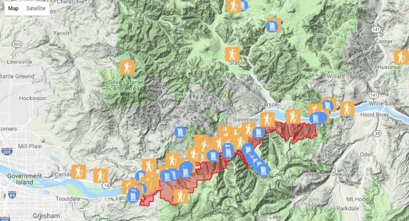
Interactive map shows trail closures in the Gorge

Check out Friends of the Columbia Gorge’s updated Find a Hike page, which features an interactive map of trails in the Columbia River Gorge National Scenic Area. The map has been updated to show the Eagle Creek burn area and it takes trail closures into account, making it an excellent resource for anyone planning their next hike in the Gorge. 


Underwood Uncovered: White Salmon River restoration project underway

By Dac Collins. March 8, 2018. The White Salmon River is choking, its mouth clogged with sand. But a restoration project currently underway at the Underwood In-Lieu Site aims to remove some of that blockage. Spearheaded by the Yakama Nation Fisheries Program, the project will focus on improving fish habitat and re-establishing fishing access at the silt-laden river mouth.

Taken on Feb. 9, this aerial photo shows the scope of the restoration project currently underway at the mouth of the White Salmon River. Photo courtesy of Yakama Nation Fisheries Program.

“We have sort of a unique opportunity here on this bar,” says Bill Sharp, project manager and fisheries research scientist for the Yakama Nation. Sharp explains that the breaching of Condit dam in 2011 released huge amounts of sediment into the river. Tons upon tons of sandy silt and gravel, which had been building up at the bottom of Northwestern Lake for nearly a century, made its way downstream and eventually settled along the mouth of the White Salmon, effectively smothering the stream bed and forming a large sandbar that rendered the Underwood In-Lieu fishing site unusable.

In-lieu fishing sites, Sharp admits, have been a contentious topic ever since their inception during the construction of Bonneville Dam. Given to the Yakama, Umatilla, Warm Springs and Nez Perce tribes, whose historic villages and fishing grounds were inundated by the Bonneville, Dalles and John Day dams, these sites were the Army Corps of Engineers’ way of mitigating the damage done to the river tribes.

Underwood was one of the five original in-lieu sites set aside by Congress in 1945. Another 26 ‘treaty fishing access sites’ have been established along the Columbia in the years since, but a loaded question remains: Are these sites adequate?

While the answer to that question is still being hashed out on the federal level today, everyone involved with the restoration project at Underwood agrees that uncovering the in-lieu site is a step in the right direction.

Michael Broncheau manages the operation and maintenance of each of the 31 tribal fishing sites along the Columbia. As a member of the Columbia River Inter-Tribal Fish Commission, he is glad to see this sort of work being done at the mouth of the White Salmon. “This site has been out of service for way too long,” he says, adding that “it’s always a positive when we can get tribal fishers back on site.” Broncheau hopes that the restored Underwood site can serve as an example for future projects on other Columbia River tributaries that have been similarly affected by sedimentation.

Sharp explains that before Condit dam was breached in 2011, “there was 30 feet of deep water with cobble bottom just off the [Underwood] boat ramp. Now that’s filled with silt, mostly sand.” That sedimentation, he says, has proven detrimental to the anadromous fish that pass through this now broad and shallow river delta. Sharp cites multiple observations of juvenile salmon being stranded at the head of this newly created bar when Bonneville Pool rises and drops during the summer months.    

The creation of this shallow, sandy delta was not an unforeseen consequence. When the dam-breaching project was proposed in the late 90’s, engineers and fisheries researchers anticipated that the river mouth would be inundated with sediment and that the Underwood In-Lieu Site would be impacted severely. This realization led to the Condit Hydroelectric Project Settlement Agreement with PacifiCorp Energy in 1999, which set aside funds for mitigation projects. 19 years later, after significant planning and forethought, those funds are now being put to use. (Additional funding for the project is being provided by the Bureau of Indian Affairs.) 

“We wanted to wait a few years to watch that bar settle,” Sharp explains. “We looked at how it reacts to flow events and pool elevations, and we feel like it’s in a stable enough condition to do this work.”

Another bird’s eye view, also taken Feb. 9, gives a better idea of how the sandbar will be dredged and reshaped. Photo courtesy of Yakama Nation Fisheries Program.

The work Sharp refers to is a collaborative process. Designed by InterFluve, Inc. of Hood River, OR and implemented by construction contractor Tapani, Inc. of Battle Ground, WA, the first phase of the restoration project is to excavate a boat basin to a depth of around seven feet. The second phase is to use that excavated material, approximately 15,000 cubic yards of it by Sharp’s estimation to build three small islands at the top of the existing sandbar. These riparian islands will then be revegetated with native grasses, sedges and trees sometime this spring.

While it’s impossible to fully restore the mouth of the White Salmon to pre-Condit conditions, the installation of these islands will at least push the river in the right direction, forcing its flow into a series of deeper side channels. This deeper, cooler water will provide critical refuge for out-migrating juveniles, as well as for the adult salmon and steelhead headed up the free-flowing river to spawn. And in terms of how the project might affect the river tribes, the bottom line is: what’s good for the fish is inherently good for the fishermen.    

Dispatch From the Trail: Atop Beacon Rock

On top. Photo: Emily DeCarlo

By Dac Collins. Feb. 15, 2018. “My advice for all of you is to get involved. Not just in your ranger district, but in your communities, wherever you are.” Jurgen Hess shouted into a stiff west wind facing a group of 15 veterans. These men and women were participating in Mt. Adams Institute?s VetsWork: Environment program: transitioning from the military to a career in natural resource management, public lands and environmental sectors, and considering where they were standing—atop Beacon Rock on the Washington side of the Columbia River—Jurgen could not have given a more fitting piece of advice.

That is because the basalt monolith on which they stood (first nicknamed Beaten Rock during the Lewis and Clark Expedition) would not be here today if not for two individuals who got involved in protecting it.

Around the turn of the 20th century, the United States Army Corps of Engineers looked at Beacon Rock and saw its potential as a pile of rubble. They needed riprap to build jetties at the mouth of the Columbia, and although the 848-foot volcanic plug was first scaled in 1901, the Corps of Engineers prioritized establishing a shipping route on the river over rock climbing on its banks.

Go figure.

Beacon Rock. Photo: Jurgen Hess

Lost on the Corps of Engineers was the fact that this hunk of basalt is a geologic wonder—the core of a volcano that was whittled away to its current shape by the Missoula Floods when they scoured the region around 12,000 to 15,000 years ago. The facts that mattered were: 1) they needed to obtain a large amount of this conveniently placed rock in order to build jetties near Astoria; and 2) TNT detonated monoliths just as effectively as it did the other mountains and rock formations that stood in their way in the past.

So by 1914, the Corps had already begun digging tunnels in and around Beacon Rock in order to figure out the best way to blow it up.

Unfortunately for the engineers, who were eager to exert their awesome power over yet another worthy adversary, two people stood between them and the rock: Charles Ladd and Henry Biddle.

Records show that a pioneer by the name of Phillip Ritz first owned the land encompassing Beacon Rock. Ritz sold the land in 1870 to banker Jay Cook, who subsequently sold it to Charles Ladd in 1904—around the same time the monolith was first eyed possessively by the Corps of Engineers.

Ladd recognized its cultural, geological and recreational importance, especially by 1914 when a group of 47 climbers (the largest group yet) scrambled to the top. So the very next year, unable to keep the Army Corps of Engineers at bay on his own, he sold the land to Henry Biddle on the condition that Biddle would work toward preserving it.

Biddle saw the opportunity to preserve Beacon Rock as a challenge, and with the help of Charles Johnson, who previously worked as a construction foreman on the Columbia River Highway, he spent the next three years building a trail to its summit. Approximately 4,500 feet long and four feet wide, the trail featured 22 wooden bridges and more than 50 switchbacks.

On the winding trail. Photo: Emily DeCarlo

Although Biddle, in 1924, wrote that “my purpose in acquiring the property was simply and wholly that I might build a trail to its summit,” he also recognized the cultural value of Beacon Rock. Considered a sacred site by Native Americans in the region, they called it ‘Che-che-op-tin’ and placed spiritual totems around its base. The rock also served as an important landmark, marking the final rapids in a series of tumultuous waterfalls and turbulent whitewater chutes that defined the Columbia River Gorge before it was dammed.

Biddle remained devoted to the monolith’s protection until he died roughly ten years later.  And in 1935, in accordance with his wishes, his children gifted the property to the State of Washington so that it could remain accessible to the public for generations to come.

Today, Beacon Rock State Park preserves the legacy of Charles Ladd and Henry Biddle. Biddle’s original trail, although improved upon and maintained by the State, still brings visitors to the top, where they are rewarded with sweeping views of the Gorge. The trail also serves as an inspiration, begging everyone who reaches its terminus to follow Jurgen’s advice and Biddle’s example. Get involved.        

   _____________________________________________________________________________________________________

One way you can  GET INVOLVED with protecting our Columbia Gorge environment is by supporting our work at EnviroGorge.  

(Click on the orange “Support” button on the upper right corner of the page.)

“The greatest threat to our planet is believing someone else will save it.” – R. Swan

______________________________________________________________________________________________________


Dispatch from the trail: After the fire

USFS releases initial assessment of 22 miles of Gorge-area trails within Eagle Creek Burned Area

By Dac Collins. Feb. 1, 2018. Nearly two months after the Eagle Creek Fire was declared contained, we are just now beginning to comprehend the damage that was done to our beloved Gorge. A report released by the Columbia River Gorge National Scenic Area on January 18 focuses on assessing the damage done to the roughly 122 miles of trails that lie within the Eagle Creek Burned Area.

Forest service staff assess Eagle Creek Trail conditions

The current conditions of these trails are varied, with some described as ‘fair’ and others ‘poor’, and others still waiting to be seen. The bottom line is that all National Forest trails located within the burned portion of the Scenic Area—South of I-84, West of Starvation Creek, and East of Alex Barr Road and Thompson Mill Road—will remain closed to the public until further notice. (Click here to see a map of the closed area.)

Mt. Hood National Forest District Ranger Janeen Tervo reported that the areas around Wahtum Lake and Rainy Lake are now open to the public.

These closures are necessary to protect hikers from falling trees, smoldering stumps and other post-fire hazards, but they also serve to protect the native flora and fauna from the damaging effects of hikers.

By merely walking on the scarred terrain, human visitors can damage fragile root systems and nesting sites. They can also exacerbate the processes of erosion and contribute to the spread of invasive species. A number of invasive plant species, including false brome and garlic mustard, have adapted to colonizing in recently burned forests and are of particular concern to botanists in the region.

According to the CRGNSA report, the U.S. Forest Service and its partners have so far been able to assess approximately 22 miles of trail within the burned area. The remaining hundred miles will not be assessed until sometime in late spring of this year. 

This initial trail assessment examines sections of the Pacific Crest National Scenic Trail, as well as parts of Oneonta, Horsetail Falls, Wahlclella, Wahkeena, Gorge, Herman Creek, Larch Mountain, Gorton Creek, Ridge Cutoff, Return and Nick Eaton Trails.

“One of the key things about this [assessment] is that it’s not normal for us to do this type of work this time of year,” says CRGNSA spokeswoman Rachel Pawlitz. “Fortunately, both the weather and our resources have aligned so that we’ve been able to really get a jump on this because we know it really matters.”

Pawlitz tells EnviroGorge that repair work has already begun on some trails on the eastern end of the burned area, and that the trails around Multnomah Falls “are also very high priorities for us because they’re very popular.”

“However,” Pawlitz continues, “there will be considerable work needed there, so we’re not really speculating on timelines for that.”

Although it does not give a timeline for the reopening of any trails within the burned area, the initial assessment does show that some trails fared better than others. The Gorge Trail (# 400), for example, is described as a ‘walkable trail’ with light burning in the area, very little tree mortality and minimal debris along the path. The Nick Eaton Trail (# 447), however, is described as ‘nearly indistinguishable’. Trail crews found down trees blocking the path and noted unstable footing caused by loose rocks and soil sloughing on steeper sections. Likewise, the Horsetail-Oneonta Loop is, according to the initial assessment, ‘in treacherous shape’, with washouts, burnt signs and unstable snags posing significant risks to hikers.

The indefinite closure of these trails is disheartening, and Pawlitz acknowledges the fact that the Eagle Creek Fire affected people on an emotional level, but we must remind ourselves that these forests are well-adapted to wildfires. In fact, they depend on them in order to regenerate naturally.  

“I don’t want to skip too quickly to the positives, because I know there are a lot of people still grieving,” she said, “but this reminds us that fire is a natural phenomenon and this is a wilderness area. And fire has restorative effects on the landscape. There are some plants and tree species that regenerate after fires. There will be more open space and a lot of species, particularly birds, will actually see an increase in the short-term. And in the long-term, some of the larger mammals will begin returning.”

Until then, there is plenty of work to be done, and Pawlitz recommends that those looking to volunteer directly with the trail restoration efforts

[/media-credit] This trail can be reached by driving east from Hood River on Old Dalles Road, where a number of county-owned public access gates permit hiking. Photo: Emily DeCarlo.

reach out to the Gorge Trails Recovery Team, a collaborative effort between the Trailkeepers of Oregon, Pacific Crest Trail Association, Friends of the Columbia Gorge and Washington Trails Association. These partnering agencies are working with the Forest Service to identify projects and organize volunteers into work parties as the projects move forward.

Crowdfunding campaigns create yet another avenue for those wanting to help. The National Forest Foundation?s Eagle Creek Fire Restoration Fund is currently accepting online donations, and there are other campaigns with roots closer to home.

‘Be There For the Gorge’ is one example. The fundraiser, organized by Oregon’s Kitchen Table in Portland, will run until March 15. The goal is to raise enough money to repair three trails in the iconic Multnomah Falls area: the Multnomah Falls Trail to upper Benson Bridge, the Wahkeena Falls Loop and Angels’ Rest Trail. Check out their website to get involved. 

In the meantime, don’t let the amount of closed trails in the Gorge keep you trapped indoors. There are plenty of beautiful places nearby that offer great hiking this time of year, especially if you venture east of Hood River. A number of low-elevation trails leading to wide-open vistas can be found in the foothills around Mosier, and they are just begging to be explored.  

Platt River Journal

Essay by Dac Collins. Jan. 24, 2018.  From where the trail dead-ends, the Platt is hidden from view. There are just too many plants conspiring to keep it that way. Bearded old-growth firs, who prefer to keep their distance from the busyness of the river, collaborate with the alders and ferns nearer the waterline to weave a dense, green veil.

[/media-credit] The Platt hidden from view

Heavy with ripe fruit this time of year, the salmonberry vines are in cahoots with the trees. Together they form a seemingly impenetrable thicket, a barrier of briars and intertwined branches that you have to want to pass through. Or else turn around and go back the way you came.

I hop off the trail instead, for even though I can’t see the creek, the laughing sound of running water is unmistakable. I bushwhack toward it, bullying my way through the underbrush and flailing at the sticky vines as they rip at the pack on my back.

I make a racket. I hum. I sing. I beat on tree trunks with the stick I’m using to clear a path through the thorns. I do this because, believe it or not, an hour’s drive east of one of the most crowded cities on the West Coast, where the mega-rich live in mansions on islands and play keep away from the damp, hungry masses huddled underneath the bridges, there are black bears in the hills. I know. I saw one on my way in here. 

Eventually I break through the forest and step into the creek bed. Free of the canopy overhead, my view opens up in every direction. Facing the headwaters to the southeast, my eyes follow the contours of the land, taking in everything but nothing in particular. I close them and try to use my imagination, try to picture the glacier that carved out this river valley as it shrank into the high country and melted away, leaving behind a chain of alpine lakes. Opening them again, my eyes climb the ridge lines cloaked in evergreen and scale the granite peaks presiding from above.

Back to my immediate surroundings, ankle-deep in the Platt, I study the shallow pool upstream. Typical for an untamed, freestone creek in midsummer, it is bony, even bone-dry in places. But the cold, clear channel of water coursing through the sun-bleached rocks still holds trout. And I harass plenty of the tiny natives, pulling them out from their underwater hiding places and into the bright world above, then removing the hook and slipping them back headfirst into the gentle current.

I spend the afternoon repeating the process, fish after fish—all of them golden, wild and gorgeous, none of them bigger than my middle finger. Eventually the shadows grow longer, the creek gets skinnier and skinnier, and I quit fishing altogether. But the next bend looks too inviting and I have nowhere to be. So I keep going, rock-hopping my way up the creek bed as the feeling settles in: the feeling that in this secluded spot, where jagged peaks compete with towering trees to blot out the late afternoon sun, where black bears gorge on salmonberries and wild trout swim in crystalline pools of melted snow, I am but a curious child.—- Journal Entry 7-9-17

[media-credit name=”Jurgen Hess” align=”aligncenter” width=”800″][/media-credit]

By |2020-09-30T19:54:10-07:0001/24/2018|Essays, Features, More, Old Articles|0 Comments

© Copyright 2013-2025 Columbia Insight. All Rights Reserved.

As a 501(c)3 nonprofit organization, all donations to Columbia Insight are tax deductible to the full extent of the law. Our nonprofit federal tax-exempt number is 82-4504894.