Stay Updated Subscribe today for the latest research + reporting about environmental news. Subscribe Now

Stay Updated Subscribe today for the latest research + reporting about environmental news.

Subscribe Now

Dac Collins

Dac Collins

Dac Collins

About Dac Collins

This author has not yet filled in any details.
So far Dac Collins has created 71 blog entries.

New pressures threaten White Salmon River corridor

Timber, glamping and a rare mushroom may be on a collision course in one of the Columbia River Basin’s Wild and Scenic Rivers


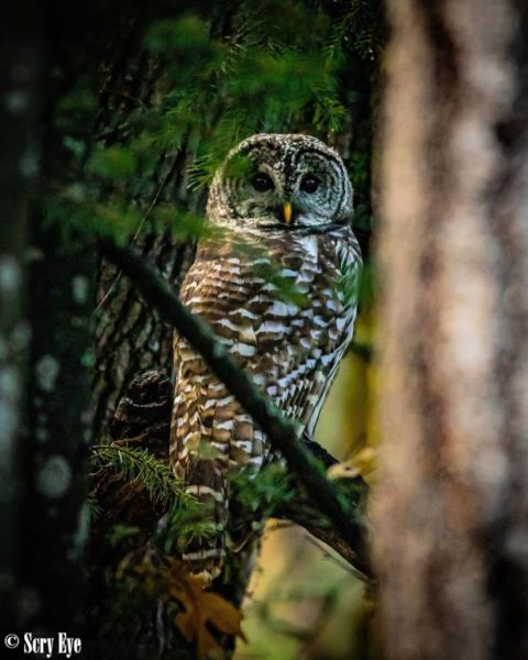
Turbulence ahead: Many forces are at play along the White Salmon River. Photo by Jane Chorazy, USFWS

By Dac Collins. May 28, 2020. When it comes to discussing their picking spots, most mushroom hunters share a trait with the fruiting fungal bodies they pursue. They’re a secretive breed.

So it came as no surprise last fall when Dr. Michael Beug, one of the Pacific Northwest’s leading mycologists and a professor emeritus at the Evergreen State College, said he was unable to describe exactly where he discovered a new species of mushroom. Only that he’d found it while walking in the woods on the east bank of lower Spring Creek—an area that falls within the National Wild and Scenic Corridor of the Lower White Salmon River and is privately owned by the SDS Lumber Company.

To appreciate the significance of Beug’s discovery—a magical-trumpet-looking species that, in his estimation, could be a relative of the black chanterelle—it’s important to recognize that the combination of aforementioned factors (a Wild and Scenic Corridor on private land) puts the patch of forest where he made it in a unique and troubled position.

Privately owned public treasure

Congress created the National Wild and Scenic Rivers System in 1968 “to preserve certain rivers with outstanding natural, cultural and recreational values in a free-flowing condition for the enjoyment of present and future generations.”

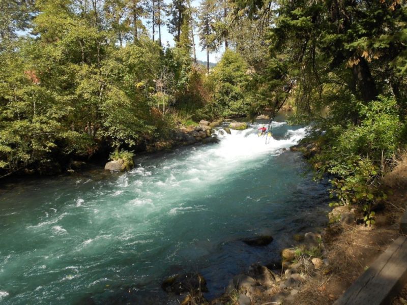
When the White Salmon River was brought into the National Wild and Scenic Rivers System in 1986, it was recognized for possessing five “outstandingly remarkable values” (ORVs): whitewater boating, geology, hydrology, cultural resources and, perhaps most importantly, the river’s namesake: fish.

The designation gave the waterway federal protection under the Wild and Scenic Rivers Act. First and foremost, the Act prohibits the construction of dams and “other in-stream activities that would harm the river’s free-flowing condition, water quality or outstanding resource values.” 

Mushroom man: Dr. Michael Beug on the hunt in “a particularly beautiful piece of woods.” Photo by Jurgen Hess

It also gave the river an administrator—a managing agency—responsible for protecting and enhancing its exceptional assets. Because of the White Salmon’s proximity to the Columbia River Gorge National Scenic Area, Congress chose the United States Forest Service (USFS) as the lead agency to implement the Lower White Salmon National Wild and Scenic River Management Plan of 1991.

A major part of that Management Plan was setting boundaries for the area to be managed.

With input from Klickitat and Skamania counties, Washington State, the Yakama Nation, local residents and private landowners, the USFS adopted boundaries for the Wild and Scenic Corridor of the Lower White Salmon. That corridor, which totals 1,874 acres, stretches 7.7 miles south from Gilmer Creek to Buck Creek.

But there are a handful of other tributaries that feed this stretch of river. One of these, Spring Creek, was recognized then—as it is now—for both its resident fish populations and its potential as a vital habitat for the spawning and rearing of anadromous fish.

Although Condit Dam was still blocking the passage of salmon and steelhead back in 1991, adult salmon have been observed in lower Spring Creek since the dam’s removal in 2011. In the 2018 Klickitat County Lead Entity Salmon Recovery Strategy, Spring Creek is listed as a priority watershed that provides spawning and rearing habitat.

Precisely because of its value to native fish populations, the boundaries of the Wild and Scenic River Corridor were amended to include the lower reaches of Spring Creek.

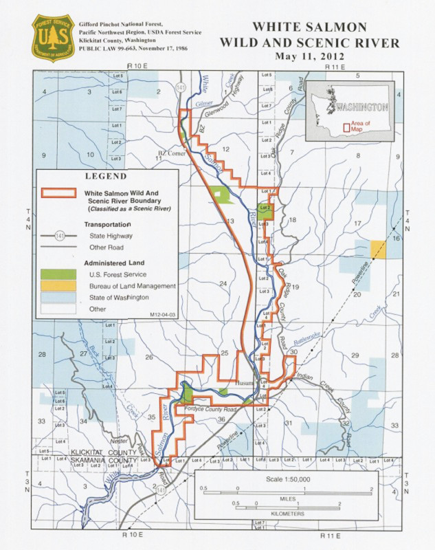
White Salmon Wild and Scenic River Plan shows the protected corridor (in red) along river. Courtesy of U.S. Forest Service

As its name implies, the spring-fed creek flows year-round, adding cold, clean water to the glacially charged flow of the White Salmon. Because it has shallow riffles and broad gravel beds, as well as coarse woody debris and a healthy, second-growth forest shading it, the creek is now frequented by spawning salmon during fall months … the same time of year when most wild species of mushroom fruit.

In fact, it was November when Beug discovered what he believes is a new species of mushroom near the east bank of lower Spring Creek.

Beug has been involved with the research, identification and discovery of new species of fungi for most of his career.

A former president of the Pacific Northwest Key Council, he’s written a number of magazine articles about fungi and is the co-author of Ascomycete Fungi of North America. In the last 12 years alone, he’s identified 50 new species of fungi in the Columbia River Gorge.

Rare mushroom find

Beug lives off Spring Creek Road on a piece of property he’s owned since 1979. He moved there full-time after retiring from Evergreen State College in 2001. Since then, he’s become intimately familiar with the neighboring forest that surrounds the lower reaches of Spring Creek.

“It is a particularly beautiful piece of woods,” he says. “Just a very, very peaceful place to walk. I’ve been picking chanterelles there for a good 20 years now.”

Beug has been able to pursue his passion because for the past two decades (perhaps longer) SDS Lumber Company, headquartered in Bingen, Washington, has allowed the public to freely access the privately owned forest on foot.

“It was just before Thanksgiving,” Beug says. “I went in to pick a few chanterelles for dinner, and to see what else was up … and here was this beautiful little surprise.”

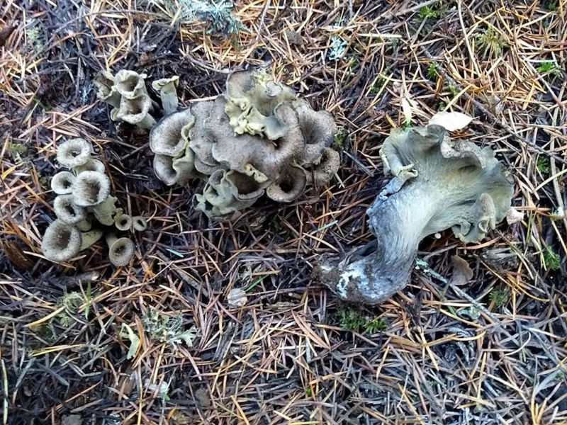
Fungal find: Michael Beug has identified some 50 new fungi species in the Gorge. But this one was new to him. Photo by Michael Beug

Beug says he immediately recognized the mushroom’s similarities with the prized black chanterelle, also known as Craterellus calicornucopioides. Sought after by chefs and foodies around the world, black chanterelles have earned a reputation, as well as a few nicknames, including “Horn of Plenty” and “poor man’s truffle.”  

“They literally look like a clump of miniature trumpets stuck in the ground,” he explains, referring to the Craterellus genus. “But this one was sort of a greenish-yellow color, not a black one.”

He harvested a sample and shared photos of the mushroom with colleagues around the country. They hadn’t seen anything like it before.

Beug is still awaiting genetic testing results, which will be the definitive answer as to whether the mushroom is indeed a unique species or simply a “color morph” of Craterellus calicornucopioidies. Either way, he says, the discovery is “something that anyone who knows anything at all about mushrooms would be very excited about.”

“Even if it is calicornucopioidies, it’s an incredibly rare mushroom in this area that’s incredibly delicious and very valuable,” he says.

Ominous signs

It wasn’t until April of this year that Beug made another important discovery in the forest around lower Spring Creek. He noticed SDS had taken down its original private property signs—which permitted public foot traffic but prohibited motor vehicles—and replaced them with signs that simply read: NO TRESPASSING.

A number of other local residents also noticed the change in signage, as well as flagging on some of the trees. Word spread through the small community and assumptions quickly formed: SDS was preparing to log the forest.

SDS has not responded to multiple requests for comment from Columbia Insight, however, and the company’s plans for the Spring Creek forest remain unclear.

“We have not seen an official application from SDS yet,” says Whitney Butler, a forester with the Washington Department of Natural Resources, adding that he’s aware of local speculation about possible logging. “Until we see an official application through the Department of Natural Resources, it’s all speculation at this point.”

[perfectpullquote align=”full” bordertop=”false” cite=”” link=”” color=”” class=”” size=””]A contentious history with SDS helps explain the local community’s cause for concern.[/perfectpullquote]

But Beug and others who are concerned for the health of the forest believe they have every right to speculate. SDS is a timber company, after all, and timber companies are in the business of cutting down trees. Just as mycorrhizal mushrooms—a class of fungi that includes Craterellus—are in the business of sustaining them.  

“There’s the litter decomposers, the wood decomposers, and there’s the mycorrhizal fungi,” Beug says, referring to the different types of mushrooms found in Northwest forests. “And all of those are critical parts of the forest ecosystem as we see it.

“Mycorrhizal fungi are important to the tree in terms of supplying minerals and water. And the trees are important to the fungi in terms of supplying the carbohydrates that the fungi need to grow and thrive.

“If you take, for example, a Douglas fir tree, and you try to grow it in healthy soil that has its full range of bacteria but no fungi, the tree will barely grow. So these mycorrhizal fungi are critical for the health of our forests and the vigor of our trees.”

Those trees, of course, fulfill essential services for the streams themselves. They contribute nutrients, woody debris and shade, and they reduce erosion while filtering out sediment and pollutants from stormwater runoff. All of this ultimately benefits the aquatic species that live in the creek, especially the salmon that spawn and die there, providing nutrient-rich salmon carcasses to fertilize the trees that will shade the creek for the next generation of fish.

Take out the trees and it all breaks down.

History of White Salmon River protest

The local community understood as much back in 1988.

In that year a group led by the Friends of the White Salmon organized to stop SDS from logging in the Spring Creek area. They protested on-site, and they picketed the Columbia River Gorge National Scenic Area office in nearby Hood River, imploring the Forest Service to intervene.

Eventually the USFS did step in, sending a cease and desist letter to SDS.

Initially, SDS complied with the letter. But years later, when the dust-up between local residents and the lumber company had settled, they logged the forest anyway, harvesting every conifer that stood between Spring Creek Road and the earthen dam that sits upstream of the road.

Among its more vocal members is Dennis White—one of the original instigators of the 1988 Spring Creek Standoff—who says he fears “SDS is back at Spring Creek to perform their final solution.”

The Columbia Gorge Audubon Society’s Washington conservation chair, White has fought for the protection of the White Salmon River for over 30 years. Along with his wife, Bonnie, and other residents of the Trout Lake Valley, he co-founded Friends of the White Salmon River in 1976 when the river was being threatened by hydropower development. He was directly involved with efforts to add the White Salmon River—and also the nearby Klickitat River—to the National Wild and Scenic River System.

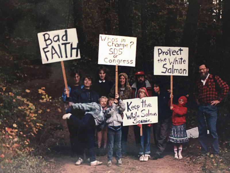
Long haul: Friends of the White Salmon River have been active since 1976. This group gathered to oppose logging in 1988. Photo courtesy of Dennis White

Representing the Columbia Gorge Audubon Society, White joined with WildEarth Guardians and Advocates for the West, a public interest law firm, in sending an April 22 letter to Columbia River Gorge National Scenic Area manager Lynn Burditt.

“The Forest Service is falling short of its duties to protect and enhance the ORV’s of the [Wild and Scenic] White Salmon,” the letter reads.

It explicitly calls out the USFS for failing to implement and revise the original 1991 Management Plan. It says the Service’s plan faced a major hurdle from the start because all of the land within the Wild and Scenic Corridor was privately owned at the time the corridor was designated. And 40 percent of it was owned by a single entity: the locally owned SDS Lumber Company. 

In fact, the USFS came up with a way to bring some of this private land into public ownership: a three-way land exchange between the USFS, the Washington Department of Natural Resources and SDS.

“It is important to remember that the (public) acquisition of SDS Lumber Company lands through exchange is one of the key features in making this a workable plan,” reads the 1991 Management Plan.

But the land exchange never happened. SDS still owns approximately 40 percent of all lands within the Wild and Scenic Corridor.

In the time since the land exchange fell through, the Forest Service has acquired a total of 144 out of a potential 770 acres. (Because the Wild and Scenic Rivers Act recognizes that “in most cases, not all land within boundaries is, or will be, publicly owned,” it encourages the lead agency to acquire land within the corridor by working with private sellers on a willing basis. However, the Act limits the federal government to acquiring no more than 100 acres per river mile.)

The 1991 Management Plan also stipulates the USFS will revise its plan every 10 to 15 years. But as the letter to Burditt points out that hasn’t happened either.

“The River Plan provided that it ‘will ordinarily be revised on a 10-year cycle, or at least every 15 years.’ The River Plan also anticipated a revision if anadromous fish were reintroduced above the Condit Dam site or if the Upper White Salmon River was designated under the Act—events that occurred years ago,” reads the local coalition’s April 22 letter. “The agency’s failure to update the plan nearly thirty years later and after these major events is an egregious delay. By failing to fully implement and timely revise its River Plan, the Forest Service is falling short of its obligations under the Act.” 

Neither Burditt nor the Columbia River Gorge National Scenic Area Office has yet responded to multiple requests for comment from Columbia Insight for this story. [A representative of the Columbia River Gorge National Scenic Area Office has since contacted CI. —Ed.]

Enter glampers

Meanwhile, roughly five miles upriver from the confluence of Spring Creek and the White Salmon River, a controversial land sale by another private timber company is moving forward.

In the time since Columbia Insight reported on this story in November 2019, Under Canvas, which calls itself “the nation’s premier glamping and luxury camping experience provider,” has been in talks with the Weyerhaeuser timberland company to purchase approximately 120 acres off of Oak Ridge Road—30 of which fall within the Wild and Scenic Corridor.

READ more on CI: United by a river, divided over management

Under Canvas chief development officer Dan McBrearty confirms the property is currently under contract.

“With this proposed project Under Canvas would provide a seasonally operated, upscale overnight campground with individual canvas tents for sleeping quarters,” McBrearty says.

McBrearty says camping would be available from April through October, and that “because of our commitment to a minimal footprint, the majority of the site would be retained as open space/natural land.”

“No access to the White Salmon River is proposed as part of the project, and the camp will be sited to ensure no ecological or aesthetic impact to the river and its buffer,” McBrearty says.

But White, who has been trying to convince the Forest Service to acquire the Weyerhaeuser tract—or at least the 30-acre portion that straddles the Wild and Scenic Corridor—sees a purchase by Under Canvas as a step in the wrong direction, since it would preempt any option of public acquisition by the Forest Service.

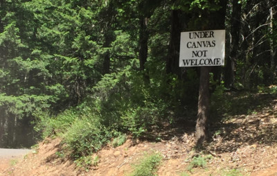
All over Under: Ad hoc signage has appeared near the White Salmon River. Photo courtesy of Dennis White

White calls Under Canvas “a motel complex masquerading as camping,” and its potential development “just another example of the U.S. Forest Service letting private interests set the management agenda.”     

“This is not just an impact on the physical environment and the Wild and Scenic River Corridor,” White says. “It’s an impact on people’s lives. All that infrastructure … water, sewage, utilities, parking lots. This commercialization is going to change the entire complexion of the river valley.”

White says a group of neighboring landowners and local residents is organizing to oppose the purchase by Under Canvas.

Columbia Insight has received a number of emails from members of this community. (Columbia Insight has vetted these comments and agreed to their authors’ request to remain anonymous.) The emails express concern about increased traffic on the rural road, as well as “the possibility of wildfire caused by campfires at the glampground.”

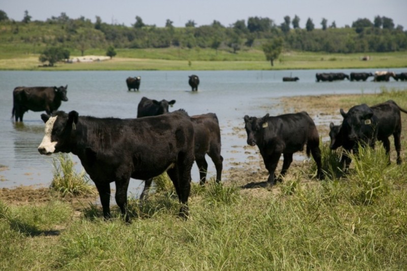
Locals also say the Under Canvas project would be incompatible with the customary agricultural uses along Oak Ridge Road. There are a number of orchards located off the road and the area is still open rangeland.

Because of this incompatibility, Under Canvas is unable to move forward without securing a Conditional Use Permit from Klickitat County. Opponents of the project worry approval of the permit will “set a precedent for unrestricted commercial development along the eastern bank of the White Salmon River.” 

“The water needed for a resort of this scale will severely exacerbate the lack of water resources for our farms, orchards and ranches,” writes one resident, referring to the 90-100 sites currently proposed by Under Canvas.

“The traffic and the negative environmental impact are not worth what this company wants to do,” writes another. “They say they’re cognizant of neighbors’ needs and desire to maintain peace, but to think that an enterprise like this has anything but dollar signs in their sights is foolhardy.”

By |2020-07-09T10:12:10-07:0005/28/2020|Conservation, Forestry, Public Lands|2 Comments

Caring for Wildlife at the Rowena Wildlife Clinic

April 9, 2020. In the third audio edition of Columbia Insight, we take a deeper look at wildlife in the Columbia River Gorge. We talk with Dr. Jean Cypher and Calley Lovett, wildlife rehabbers from the Rowena Wildlife Clinic, and discuss some of the issues affecting wildlife in the region… 

Photo credit: Calley Lovett, Scry Eye Photography

By |2020-04-09T11:41:28-07:0004/09/2020|Natural Resources, Podcasts, Wildlife|1 Comment

Volunteers Help Monitor Water Quality in the Columbia

Lorri Epstein (bottom left) and volunteers collect water samples at a popular recreation beach on the Columbia River. Photo courtesy of Columbia Riverkeeper

By Dac Collins. March 26, 2020. Earlier this month, Columbia Riverkeeper submitted new water quality data to the Oregon Department of Environmental Quality (DEQ). The watchdog group does this every year as part of the DEQ’s Volunteer Water Quality Monitoring Program, and the data comes from 18 sites along the Columbia River — a number of which are popular recreation beaches and public parks.

Lorri Epstein runs Riverkeeper’s monitoring program, which relies on volunteers to go out and collect samples on a regular basis. She says the program is currently focused on testing for e. coli in these locations.

While there are a number of other pollutants affecting the Columbia — including DDT, arsenic, flame retardants and PCBs — Epstein says that e. coli is important because of its immediate human health effects.

“E. coli is also an indicator bacteria,” she says, “so if you’re finding e. coli in the water, that indicates that there are also very likely a whole host of other pathogens in that water.”

And as Epstein explains, these volunteer-driven programs fill an important gap in the state’s regulatory process.

“Our lab equipment is on loan from DEQ, and they support us with supplies, which is amazing. And they have recognized that volunteer monitoring programs, like ours, collect a lot more data and get a lot more information than they would be able to on their own,” Epstein says.

“It’s interesting because a lot of people look at a place like Waterfront Park in Hood River, where there’s an obvious swimming beach that’s been roped off, and they assume that someone — the city, the county, the port, whoever — must be monitoring this to make sure it’s safe for kids to swim. But that’s not actually happening,” she continues.

“That’s where Riverkeeper comes in to do monitoring and fill in that gap.”

According to DEQ spokesperson Laura Gleim, the data that was submitted by Riverkeeper earlier this month is now available through a publicly accessible database known as the Ambient Water Quality Monitoring System (AWQMS).

“AWQMS contains all of the water quality data from DEQ and our partner organizations, including the U.S. EPA and volunteer monitoring organizations,” Gleim says.

“DEQ runs a quality control check on the data from volunteer monitoring organizations before uploading it into the database…and the data in this database goes back decades.”

She also says that in recent years, “over 70 different organizations have submitted data to the DEQ for Oregon’s water quality assessment.”

This data is critical in gaining a better understanding of the various pollutants affecting Oregon’s waterways, and it helps the DEQ determine which water bodies (or sections of river) fail to meet the state’s water quality standards for aquatic life, recreation, drinking, agriculture, industry and other uses. Waterways that exceed those standards are added to the state’s 303(d) list.

(Click here for an interactive map that shows these listed waterways and provides additional information about the various pollutants affecting them.)

Epstein adds that while the data collected by volunteers* at places like Waterfront Park is submitted regularly to the DEQ, it can also be used to inform the public directly through the Swim Guide app. This data is uploaded to the app in real-time, she says, so that users can determine which beaches are safe for swimming.

“That way, we’re getting this information into the hands of the public and the people who are actually recreating.”


*Riverkeeper is currently looking for volunteers to help with its water quality monitoring program. Click here to learn more about volunteer opportunities.

By |2020-03-26T11:46:01-07:0003/26/2020|Natural Resources, News, Water|0 Comments

Cows and Compromises in the Owyhee Canyonlands

Photo courtesy of BLM, Wikimedia Commons

Proposed legislation seeks a compromise between conservationists and the local ranching community in Malheur County.

By Dac Collins. March 12, 2020. Senators Ron Wyden and Jeff Merkley are co-sponsoring legislation that will create approximately 1.1 million acres of wilderness in the Owyhee Canyonlands, and will add a 14.7 mile stretch of the Owyhee River to the National Wild & Scenic Rivers system. Known as the Malheur Community Empowerment for the Owyhee Act (or the Malheur CEO Bill), the purpose of the legislation is to “promote the long-term ecological health of the federal land to support communities and natural resources.”

In its current form, the Bill represents the culmination of months of closed-door negotiations between two groups in eastern Oregon that are fundamentally, historically and diametrically opposed to one another: the environmental, recreation and conservation faction, which has long championed wilderness protections for the public lands within the Owhyee Canyonlands, and the local ranching community, which has fought against those protections at every turn in order to preserve a livelihood that is wholly dependent on grazing livestock on those lands.

Decades in the making

“What’s interesting about this process is that the effort to protect this place has been decades in the making,” says Corie Harlan with the Oregon Natural Desert Association (ONDA).

As one of ONDA’s campaign managers, Harlan has advocated for the protection of this landscape for the last 8 years. And she explains that ONDA was a key player in the 2015 formation of the Owyhee Coalition — a group of recreation- and conservation-minded advocates that sought to protect millions of acres in the Canyonlands via Wilderness, Wild & Scenic River and National Conservation Area designations.

“As that group came together,” Harlan says, “it also became clear in late 2015 that there was possibly an opportunity for a national monument designation by the Obama administration. Given how long this effort has been going on, and how deserving this place is of protection, it made sense to have all the possible tools on the table to make that happen.”

Photo courtesy of Greg Burke, ONDA

Then came the armed occupation of the nearby Malheur Wildlife Refuge in 2016, which brought national attention to the area and showed the intense, sometimes violent, friction that exists between many Westerners (particularly Western ranchers) and the federal government. Ultimately, the Obama administration didn’t include the Owyhee when it moved forward with designating other deserving places, like Cascade Siskiyou and Bears Ear, as national monuments.

Harlan says the state-wide push for monument status also resulted in the formation of the Owyhee Basin Stewardship Coalition (OBSC). Made up primarily of local ranchers and residents of Malheur County, the OBSC became the organized opposition group to any kind of protective designation in the county.

So after succeeding in fighting off the monument designation in 2016 (Malheur County residents voted overwhelmingly against the monument proposal), the OBSC continued with its “Our Land, Our Voice” campaign, while ONDA continued to seek out pathways to wilderness protections. But at some point, Harlan says, “this tipping point had been crossed.”

“For the first time,” she explains, “you had leaders in Malheur County realizing that the effort to protect this place isn’t going away, and that we needed to sit down together and figure out what this might look like.”

And in late 2018, the OBSC approached Sen. Wyden about facilitating a discussion between the opposing coalitions. Wyden agreed, announcing in April of last year that he would lead a collaborative process to seek some sort of middle ground in the Owyhee Canyonlands.

The Malheur CEO Bill that was rolled out in November is the result of this months-long collaborative process that brought together sportsmen, ranchers, conservation groups, state universities, county leaders and tribal representatives, along with state and federal agency representatives.

ONDA played a crucial role in these discussions, which revolved, in part, around an issue that has been the subject of intense debate for generations: grazing in wilderness areas.

The first draft of the 1964 Wilderness Act explicitly forbade grazing in wilderness, but language permitting grazing was included in the final draft of the Bill. Ever since then, it has been viewed by some as an exception to the general premise of “wilderness”, which was defined by Howard Zahniser of the Wilderness Society when he helped write the Act in ‘64:

[perfectpullquote align=”full” bordertop=”false” cite=”” link=”” color=”” class=”” size=””]“A wilderness, in contrast with those areas where man and his own works dominate the landscape, is hereby recognized as an area where the earth and its community of life are untrammeled by man, where man himself is a visitor who does not remain.”[/perfectpullquote]

“For ONDA,” Harlan says, “we showed up and our goal was to really make sure that the irreplaceable values of this place — the wildlife, the waters and the land — were understood and represented. For other people sitting at the table, they wanted more responsive management decisions or more stability for their livelihood. Everyone came with their own set of priorities.

“So what you have here is compromise legislation. Senator Wyden pulled all these disparate voices together and crafted a proposal seeking middle ground.”

The proposed legislation would designate 1,133,481 acres of the existing 4.5 million acres of federal (BLM) land in Malheur County as wilderness. It would also bring 14.7 miles of the Owyhee River into the National Wild and Scenic Rivers system, and it would provide economic development opportunities for the county, including the establishment of loop roads and improvements to State Parks and other tourist related amenities on Owyhee Reservoir.

Graphic by Alan Kenaga, Capital Press

And while an objective of the Bill is to “promote and foster cooperation, communication, and understanding, and reduce conflict among all users of the federal land,” the language in the Bill includes a handful of other objectives that seem to prioritize one particular user above the others.

The first three objectives, as they are laid out in the Bill, are to:

  • support and grow local communities and economies
  • protect the cultural resources and western traditions for which the federal land is known
  • maintain grazing on the federal land

So while the legislation aims to establish wilderness in order “to promote the long-term ecological health of the federal land”, its plainly stated primary objectives are to ensure that the tradition of grazing cattle on that land is supported, protected and maintained.

But what if the tradition of grazing cattle on federal land is detrimental to the long-term ecological health of the land?

This is the very question that some opponents to the Malheur CEO Bill have been asking. And it gets right at the controversy lying at the heart of this Bill.

The cattle controversy

Katie Fite is the public lands director for Wildlands Defense, a wildlife and wilderness advocacy group based in Boise, Idaho. She has a background in biology, and has lived and worked in the Sagebrush Sea for most of her career.

“I’m very familiar with this country in eastern Oregon that the Malheur Bill would cover. And I’ve spent a tremendous amount of time looking at sagebrush habitats, and what happens to those habitats as a result of livestock grazing,” Fite says.

She points to a number of studies showing the detrimental impacts that cattle grazing has on native species and federal lands — particularly those in desert areas that receive less than 12 inches of rain a year.

“Damage is gonna happen,” Fite says. “Especially in these arid landscapes where water is so precious and so limited, and so readily damaged by cows. You couple that with the damage to sagebrush habitat from cattle grazing and trampling, and the fact that cows cause cheatgrass and weeds to proliferate…there’s just no freeboard.”

Opponents of the Bill point to cattle grazing as one of the leading causes of water pollution in desert landscapes. Photo courtesy of WildLands Defense

“So here we have sage grouse, pygmy rabbits and other unique species in serious, serious trouble. And to propose this huge grab-bag of a bill that, in many different ways, would elevate livestock grazing in this very landscape that’s falling apart because of the effects of grazing in the first place. It’s madness.”

Stoking Fite’s concerns is the fact that the Bill would establish a 13-person advisory board that would help determine how the BLM manages the land. Of those 13 seats, the Bill dictates that six seats would be given to ranchers, and another two would be given to local business interests — with the remaining five given to conservation and/or recreation groups and one representative from the Burns Paiute Tribe. From Fite’s perspective, this looks an awful lot like a stacked deck.

But the ranchers who live and work in Malheur County say this configuration makes perfect sense. They strongly believe that because of their proximity to — and dependence on — the land, they have a better understanding of how to manage and care for it. And from their perspective, grazing cattle is an essential part of that.

Elias Eiguren lives in Arock, Oregon, where he runs a cattle operation that’s been in his family for nearly a hundred years. He is also the Treasurer of the OBSC, and has been involved with the “Our Lands, Our Voice” campaign since its inception during the Obama years.

“I think our proximity to this land gives us a different perspective on how it ought to be managed,” Eiguren explains. “As opposed to folks who are further removed and think that if we just designate it and call it wilderness, man will step away from the landscape and it will return to health…and all the past sins that man has imposed upon the landscape will just disappear.”

For Eiguren, this doesn’t seem very realistic, and he contends that cattlemen are actually the best stewards for the landscape because their fate (and that of future generations) is directly tied to it.

Photo courtesy of BLM

“Cattle grazing done wrong can certainly cause long-term damage to the land. I’ll agree with that. But cattle grazing done right can have some excellent benefits to the land,” he adds.

He says those benefits include lowering the risk of large wildfires and combating the spread of invasive cheatgrass. And he points to his own private property as an example:

“If you were to come to our private property, which is about a tenth of the acreage — or less — of what we graze on public ground, I think that you could look at our land and say that, for the most part, it’s in pretty darn good shape. You don’t have the weeds, and you don’t have the monocultures, and you don’t have a lot of the issues you see out on public lands.”

Eiguren does admit that there are “certain places that probably shouldn’t be grazed in the way that they are now.” But he still sees cattle grazing as a tool that can be used to improve the health of the land, and he says that by promoting grazing as an adaptive management strategy, the Bill will prove beneficial to the long-term ecological health of the Owyhee Canyonlands.

“Ultimately, I think it strikes a balance in the end,” he says.

The Malheur CEO Bill still faces a few hurdles before it can pass, however, and a key next step may be an upcoming hearing in the Senate Energy and Natural Resources Committee. The language and intent of the Bill could also change as it moves forward.

Photo courtesy of Jim Davis, ONDA

Harlan says that ONDA is “aware of some of the concerns within the conservation community about this Bill.”

“We’re listening closely to those concerns and taking them seriously. And we’re really encouraging those folks and organizations to reach out directly to Senators Wyden and Merkley to help make the Bill the best it can be and do right by this landscape.”

Navigating a Changing Climate: The power of public transit

Photo by Jurgen Hess

By Dac Collins. Feb. 20, 2020. Search Google images for “climate change” and you will see burning forests, melting glaciers and a hurricane pinwheeling off the coast of Florida. Keep scrolling and you’ll find photoshopped images of the Earth catching fire, along with despondent polar bears adrift on icebergs. Scroll a little further and you’ll see the Statue of Liberty standing neck-deep in New York Harbor.

These are all creative depictions of the effects of climate change. Are some of them over-dramatized? Surely. Straight out of Hollywood? You bet. But to quote one of today’s most unquotable philosophers: “Our art is a reflection of our reality.”

Now scan through these images once more and you’ll notice another recurring theme: pictures of power plants and industrial smokestacks spewing clouds of pollution into the air.

These pictures have become so synonymous with the notion of human-caused climate change that they have become its go-to symbols — its scapegoats, if you will. And for good reason.

But no matter how far you scroll through this seemingly bottomless well of images, you will not find a single picture of an automobile, a diesel truck or a crowded highway.

Which seems strange, if not wrong…seeing as transportation is now the biggest source of carbon emissions in the United States.

According to the Environmental Protection Agency, the transportation sector made up 29% of the country’s greenhouse gas emissions in 2017. And of that percentage, a majority of those emissions were released by what the EPA calls “light-duty” vehicles — our rides, pickups, wheels, jalopies, coupes, clunkers, whips and minivans. Our daily drivers.

Graph courtesy of the EPA

So why the disconnect?

Is it because we would rather view climate change as a byproduct of some force that is beyond our control? Because we’re so used to blaming energy companies, greedy corporations and incompetent presidents pushing corrupt policies? Or is it simply that Americans — the free-spirited inventors of the Mustang and the monster truck — love our cars far too much to blame them for the mess we’ve found ourselves in?

Perhaps it’s a mixture of all three. But any country whose citizens spend their weekends drinking light beer and losing their hearing while stock cars race around in a circle 200 times should probably take some time for self-reflection.

A culture steeped in Cadillacs

Now that we’re looking in the rearview, we can see that for the last century or more, we’ve built our transportation systems around a pillar of American culture: the private car.

It’s hard to determine exactly when America fell in love with the automobile, but it probably happened sometime between the invention of the Model-T in 1908 and the first recording of “Not Fade Away” in 1958. (At one point in the song, Buddy Holly sings that his “love’s bigger than a Cadillac”…but he never got to see the 2020 Escalade ESV.) A number of artists would follow suit, writing hits about the quintessential Caddie during the latter half of the 20th century — from Johnny Cash and Bruce Springsteen to The Clash and Outkast.

By 1980, roughly 87 percent of American households owned one or more vehicles. And in September of 1997, The New York Times ran this headline: “Number of Cars is Growing Faster Than Human Population”.

This advertisement for a Cadillac Sedan deVille ran in a 1959 issue of Life Magazine. Photo by Brian 

Fast forward to today, and we’re still singing about Cadillacs.

So it’s only natural that when we start having real discussions about how to tackle climate change — and how each and every one of us can decrease our own carbon emissions — the private car takes center stage. A nation of innovators, we point to electric vehicles and hydrogen fuel cells as the best possible solutions. And they are certainly part of the solution.

But electric vehicles and alternative fuels have their own challenges and limitations (more on that in an upcoming story*). And while changing our cars will be a priority in the years to come, we also have to consider another, more comprehensive approach: changing our culture and embracing public transit.

To put it simply, buses and trains can move more people with fewer vehicles. And fewer vehicles translates to less carbon emissions. According to the Federal Transit Administration: “Public transportation produces significantly lower greenhouse gas emissions per passenger mile than private vehicles…with light rail systems [producing] 62% less and bus transit [producing] 33% less.”

Efficient public transit systems are also extremely effective at easing congestion on city streets and highways, thereby decreasing the amount of vehicles idling in traffic. The Winnipeg-based Climate Change Connection explains it this way:

“During rush hour in Winnipeg, there is an average of 1.2 persons per car. At that rate, 100 cars and 550 meters of traffic lane are required to accommodate 120 people. Only 2 buses and 25 meters of traffic lane can do the same job, reducing congestion, noise and greenhouse gas emissions by over 90%.”

And from a rider’s perspective, taking the bus or train cuts down on the cost of fuel and vehicle maintenance, making it a viable way to save money. It also makes for a more enjoyable trip across town. Ask anyone who’s rolled past bumper-to-bumper traffic in the bus lane while reading a book or taking a nap.

Just another day on 1st Avenue in downtown Seattle. Photo by Oran Viriyinci

These benefits are already catching on in some of our nation’s more congested cities, and Seattle is a prime example. After pouring billions of dollars into expanding its light rail and bus systems, the city has seen a steady increase in ridership over the last ten years. It’s been called “America’s Bus-Lovingest Town”, and according to the Seattle Business Magazine, nearly twice as many people are now taking public transit to work than are driving alone.

But we don’t all live in cities, and as the American Public Transportation Association points out: roughly 45 percent of Americans have no access to public transportation.

So a key challenge for smaller towns and rural communities today is not just building and implementing public transit systems. It’s getting people to recognize, appreciate and use a system that they’ve never had before — one that is directly at odds with our Cadillac culture.

Incentivizing public transit in the Columbia River Gorge and beyond

Columbia Area Transit (CAT) is one of the many local transportation districts in the region that is meeting this challenge head-on. Formally known as the Hood River County Transportation District, CAT has has been providing public transit services in the county since 1993. In recent years, however, those services have expanded in a big way.

Up until 2017, the local bus functioned as a Dial-a-Ride system, and people wanting to ride the bus had to call and make reservations ahead of time. 

Today, CAT has three fixed routes serving different parts of the Gorge. There is the Hood River City route, which stops at 13 different places in Hood River and runs on weekdays until 8pm. There’s the Upper Valley and Gorge-to-Mountain routes connecting Hood River to the upper valley and Mt. Hood Meadows. And there’s the Columbia Gorge Express route, which connects the Dalles to Portland with stops in Hood River, Cascade Locks, Multnomah Falls and Troutdale. (The Columbia Gorge Express was traditionally run by ODOT, but CAT took over the route in November of last year.)

Hood River resident Dillon Simmons uses the Columbia Gorge Express on a daily basis, taking the morning bus to get to work in Troutdale and returning home by bus in the evening. Photo by Jurgen Hess

Leanne Hogie serves as the Board Chair of CAT, and she explains that a number of factors have spurred the district’s recent growth spurt. One is the growing population of the Gorge, and the consequent increase in private cars and parking issues. She also points to the steady growth in tourist traffic, and notes that one of the best features of the Columbia Gorge Express is that it connects with some of the more popular trailheads and recreational communities in the Gorge.

“We thought there were a lot of different things coming together that might make this the time for public transit to really take off,” Hogie says.

Another factor that helped the CAT bus “take off” in recent years, she says, was the Oregon legislature’s creation of the State Transportation Improvement Fund in 2017, which provides an entirely new source of funding for transportation districts in the state.

“That [fund] is making a huge difference for us,” Hogie explains. “It’s adding about half a million dollars annually to our transportation budget.”

That money allowed CAT to buy the buses and hire the drivers that are key to its new fixed route systems. But it didn’t actually get people to ride those buses, and Hogie says that’s been the district’s biggest hurdle over the past couple of years.

“It’s a cultural shift,” she says. “We’re in a place where many people grew up and they never used public transit.”

So in an effort to incentivize public transit, the transportation district made a big announcement earlier this month and rolled out the annual GOrge pass. For the introductory prices of $30 (for adults) and $15 (for children 17 and under), pass-holders get unlimited rides on CAT’s fixed routes through the end of 2020.

(These prices are available until May 18. Click here to learn more about the GOrge pass or to buy a pass online.)

When you consider that it costs a little over $5 (taking into account the cost of fuel alone) to drive from Hood River to Portland in a 2020 Subaru Outback, $30 for unlimited round-trips starts to look pretty appealing. Which is exactly the point, Hogie says.

[perfectpullquote align=”full” bordertop=”false” cite=”” link=”” color=”” class=”” size=””]“We want to remove the financial impediment as much as possible because we really want to get riders on this bus. The more people we get on this bus, the better it is for us, and the better it is for the environment.”[/perfectpullquote]

And looking beyond the Columbia River Gorge, it seems that a growing number of Northwest cities and towns are having success increasing bus ridership using similar incentives.

Olympia’s Intercity Transit took it one step further and got rid of fares entirely at the beginning of 2020. Now, instead of paying $1.25 for local routes and $3 for a ride to Lakewood or Tacoma, anyone can ride the bus for free. (Well, sort of. Funding for the bus system actually comes from an increase in the local sales tax that Thurston County voters approved in 2018. Which means that passengers are essentially paying for their bus fares when shopping.)

The buses on Camano and Whidbey Islands are also fareless, as is the City of Missoula’s Mountain Line — it’s been that way since 2015. But it was another college town that really paved the way, proving that the right incentives can go a long way in getting more people to take the bus instead of driving their own cars.

The Corvallis Transit System (CTS) went fareless on Feb. 1, 2011, and the effects were almost immediate: ridership increased by nearly 38% over the next 12 months.

As Corvallis’ Transit Coordinator Tim Bates explains: “The impetus for this was the Corvallis Sustainability Coalition, which was looking for ways to reduce our carbon footprint and operate more sustainably.”

“One of the suggestions was to get more people on the bus, which led to this idea that the biggest incentive for doing that would be to eliminate fares,” Bates continues.

Corvallis was able to achieve this by enacting a Transportation Operating Fee, which raises the the monthly charge for the City’s utility customers and serves as the funding mechanism that allows for fareless transportation.

Strolling past a bus stop in downtown Portland. Photo by Ian Sane

In the years since, CTS has also used money from the State Transportation Improvement Fund to expand its service area. Bates says this “windfall of money” has allowed them to grow their system by roughly 30% over the last two years, which means the buses can now start earlier and run later.

But looking back on when the City of Corvallis implemented the Transportation Operating Fee in 2011, he recalls that the most common complaint they received was from people who didn’t want to pay a monthly fee for a transit service they never planned to use.

“So, our response was — and would still be now— that even if you don’t use it, it means less cars on the road and less fighting for parking spaces downtown. It’s also reducing our carbon footprint and helping the climate,” Bates says.

“And now, if you fast forward nine years…it’s just wildly popular. We’ve heard from social services people who could not do without it, and the same from lower income people. Even people who have sold their car and are going completely car free, they can do that with a fare-free system.”

Of course, going car-free might not be an option for many of us at this point. But having access to a dependable and affordable public transit system at least gives us the freedom to choose. And isn’t that what America’s all about?

Well, that and…Cadillacs.


*This is the first in a series of stories about the role of transportation in combatting climate change.

By |2020-03-26T11:49:04-07:0002/20/2020|Climate Change, Features|2 Comments

Farmers Respond to Trump’s Navigable Waters Protection Rule

Photo by K-State Research and Extension Center

By Dac Collins. Feb. 6, 2020. The Trump Administration has removed federal protections for millions of miles of the nation’s streams, wetlands and smaller water bodies. Trump’s Navigable Waters Protection rule, which was signed into law on Jan. 23, scales back which waterways qualify for federal protection against pollution and development. It undercuts and replaces the Waters Of The United States (WOTUS) rule that was implemented during the Obama Administration, and it represents the most significant rollback of the Clean Water Act since it was implemented in 1972.

Also known as the Clean Water Rule, WOTUS broadened the definition of federally protected waterways to include not only larger water bodies such as lakes and rivers, but also ephemeral streams, wetlands and groundwater sources. Trump’s newly revised rule, by contrast, narrows that definition to exclude ephemeral streams — those that flow for only part of the year and are dependent on rainfall and/or snowmelt. It also excludes waste treatment systems, certain wetlands, groundwater and farm watering ponds.

The Administrator of the Environmental Protection Agency supports the narrower definition imposed by the new rule, even though some of the EPA’s outside scientific advisers recommended against it. Those advisers wrote Administrator Wheeler in October of 2019, saying that “aspects of the proposed rule are in conflict with established science…and the objectives of the Clean Water Act.”

The Navigable Waters Protection rule does not go into effect until 60 days after it was signed, and a coalition of 14 states has already moved to sue the administration. But this hasn’t kept Trump from crowing about the new rule, which he is touting as a big win for America’s farmers.

And a number of Republican lawmakers representing rural districts have applauded the move. That includes U.S. Rep. Greg Walden, who said the new rule is proof that Trump is “listening to the concerns of America’s farmers and ranchers.”

So how do farmers and ranchers in the Columbia River Basin really feel about Trump’s Navigable Waters Protection rule?

It depends on who you ask.

Ken Polehn runs Polehn Farms, a third-generation family farm located just outside of The Dalles, Oregon. They grow a variety of cherries, pears and table grapes using water diverted from the Columbia River. And although the Trump Administration’s revised rule does not affect the Columbia’s status as a federally protected waterway, Polehn believes the narrower definitions imposed by the rule will benefit farmers throughout the Basin.

“I do believe it will be a benefit to agriculture in our region, and to farmers in particular,” says Polehn, who also serves as President of the Wasco County Farm Bureau. As an example, he points to some of his neighbors who raise cattle and have traditionally utilized ponds that catch runoff to water their stock. Because these fall under the category of “farm watering ponds”, they are no longer subject to federal oversight under the revised rule. Polehn says this is a good thing, since many in the local agricultural community have long complained about what they see as over-regulation by the federal government.

“I think it’s a good thing we backed off a little bit on the regulations, so we can have a system that we can all live with,” he says.

Travel roughly 20 miles west of Polehn Farms and you’ll find another farmer who diverts water from the Columbia to grow crops. He also has an entirely different perspective on the Navigable Waters Protection rule.

“I guess I’m a little offended by the rollback,” says Brian McCormick of Idiot’s Grace Farm, an organic farm and vineyard in Mosier that specializes in wine grapes and grows a variety of other vegetables in their small-scale market garden.

McCormick talks about his responsibility to “farm appropriately”. And in the dry foothills of Mosier, which receive approximately 21 inches of rain a year (or 17 inches less than the national average), this responsibility translates to using water sparingly and taking every precaution to keep water sources clean.

“I don’t see policy makers as the enemy, and so I think good policy and good regulation is useful,” he says.

“There are certainly bad policies,” McCormick continues, “and I could just as soon be on the other side and be angry that I’m not allowed to use water from my own pond for irrigation, for example. But I don’t think farmers should get to do their thing no matter what.”

“I mean, farmers have a lot of uncertainty in their lives. But that doesn’t mean we have to roll back water protections.”

Meanwhile, there are farmers like Paulette Lefever Holbrook, who operates a dry-land farm near Goldendale, Washington. She raises lambs and hogs, along with wild plums and other garden produce, and while she disagrees with the Trump Administration’s recent move to roll back federal water protections, she also feels that federal regulators can be overzealous and overly restrictive at times.

Referring to the new rule that was signed into law on Jan. 23, she says, “I’m really nervous, because water quality is so important to me. My nervousness is that when we are taking away protections and relaxing the rules for what we can put in our streams…I think we’ve got a problem.”

Holbrook says she is primarily concerned about the health of groundwater sources and local aquifers, which she relies on to water her livestock and gardens. But speaking to her own experience dealing with federal regulators, she says, “I’ve seen good regulators and I’ve seen bad regulators.”

“Personally, when it comes to government regulations, I think it is hard to expect everybody to have the moral compass to do the right thing. But when it comes to government oversight, I have seen too many government people that are too zealous, and that might not have the balance and the understanding of what the farmer is going through.”

In this sense, Holbrook is like a lot of the other farmers and ranchers in the Columbia River Basin. She is wary of government regulations that make an already difficult way of life even harder…but she acknowledges the critical importance of clean water, and believes that someone (or some entity) has to ensure that we are doing everything in our power to protect our most important resource.

Like Polehn says: “Agriculture believes in clean water. We need it to produce healthy crops. I mean, we’re probably the best conservationists out there because it’s our livelihood.”

By |2020-02-06T07:58:58-08:0002/06/2020|Agriculture, News|0 Comments

© Copyright 2013-2025 Columbia Insight. All Rights Reserved.

As a 501(c)3 nonprofit organization, all donations to Columbia Insight are tax deductible to the full extent of the law. Our nonprofit federal tax-exempt number is 82-4504894.