The state has struck a deal with a German company for a satellite-based monitoring system already in use in Canada and Europe
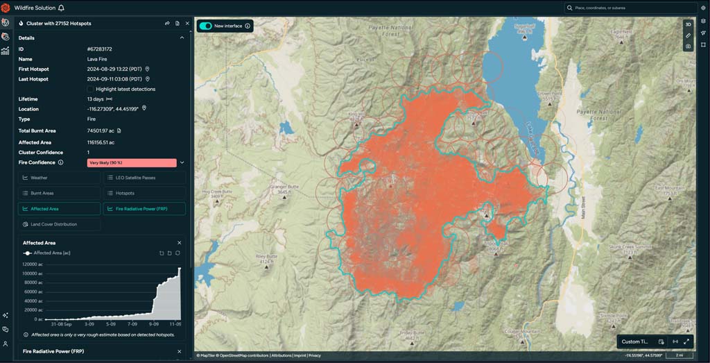
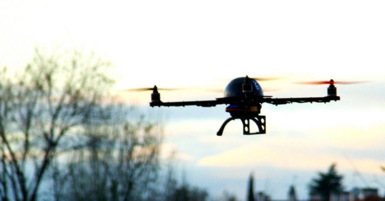
Where the blazes? Satellite views of wildfires, like imagery of Idaho’s 2024 Lava Fire, could help firefighters detect new fires in rapid time. Photo credit: OroraTech
By Kendra Chamberlain. October 22, 2025. The state of Idaho has inked a $150,000 deal with Germany-based OroraTech to use satellites to monitor state-managed forested land for wildfires. The state has set a staggering fire suppression goal of keeping 95% of wildfires at 10 acres or smaller.
The Idaho Department of Lands is using OroraTech’s wildfire monitoring program for a one-year demo, according to the Idaho Statesman.
The satellite system will be used alongside Idaho’s existing mountaintop camera detection system. The department will compare the two systems and other wildfire detection technologies then determine which best suits the state’s needs.
Many states have installed camera networks across mountainous and forested areas to help spot wildfires as they appear. But OroraTech believes satellite systems offer advantages over terrestrial systems in detecting wildfires, according to company spokesperson Zachary Ricklefs.
Wildfire cameras are amazing pieces of equipment, said Ricklefs, but deploying them in the field is tricky. The expensive rigs require running power cables up mountains, for example, and the field of view of each camera is limited, meaning multiple cameras are required to cover a large area.
“If you have a small area that you can cover with one camera, two cameras, five cameras, that’s great,” Ricklefs told Columbia Insight. “If you’re covering the state of Idaho, it’s a little different.”
Satellites, on the other hand, can —and currently do—survey huge swaths of land relatively easily.
“And that’s where we come in,” said Ricklefs.
The company has launched 10 of its own CubeSats into low Earth orbit, and taps into government agency satellites from around the world in low Earth and geostationary orbit to piece together its global thermal imaging platform.
“Basically, we integrate as much thermal data as we possibly can, and by doing that we can then really accurately detect and track wildfires through our platform,” said Ricklefs.
The platform works in near real time. Data around an emerging fire can be delivered to fire agencies within 10 or 15 minutes, according to Ricklefs.
“We can very quickly say, ‘Oh, we just detected a fire on our last satellite overpass, here’s the coordinates for it, here it is placed on a map, here’s how big it is, how intense it is,” said Ricklefs. “And that way, firefighters can get out there as quickly as possible.”
OroraTech also uses artificial intelligence to predict how a fire may spread through given terrain.
The fire spread modeling uses data including wind speeds, humidity, temperature and other weather conditions. It synthesizes this with data from previous fires, and local vegetation and terrain information to help the AI model predict how a fire might move over the following 24 hours.
OroraTech, which was founded in 2018, works with agencies in Europe, Canada and South America on wildfire detection. The company is only now entering the market in the United States.
Idaho is the first state to contract with OroraTech.
The company also recently signed a deal with Colorado’s Larimer County Sheriff’s Office to provide its wildfire detection system to fire-prone Fort Collins and the surrounding area.
“We’ve had a lot of experience detecting fires around the world, and we want to really start bringing that experience to the United States,” said Ricklefs.


